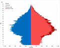
Demographics of London

Last updated

Demographics of London
London population pyramid.svg
PopulationIncrease2.svg 8,799,800 (2021)
DensityIncrease2.svg 5,854/km2 (15,160/sq mi) (2020 estimates) [1]
Growth rateIncrease2.svg 7.7% (2011 - 2021) [2]
Life expectancy
  maleDecrease2.svg 80.3 (2018-2020) [3]
  femaleSteady2.svg 84.3 (2018-2020)
Fertility rateDecrease2.svg 1.52 (2021) [4]
Infant mortality rateDecrease Neutral.svg 3.4 live deaths/1,000 live births (2018-2020) [5]
Nationality
Nationality British
Major ethnicDecrease2.svg White: 53.8% (2021)
Decrease2.svg White British: 36.8% (2021)
Minor ethnic
Increase2.svg Asian British: 20.8% (2021)
Increase2.svg Black British: 13.5% (2021)
Increase2.svg Mixed: 5.7% (2021)
Increase2.svg Other: 6.3% (2021)
Language
Spoken British English (main language: 78.4%)

The demography of London is analysed by the Office for National Statistics and data is produced for each of the Greater London wards, the City of London and the 32 London boroughs, the Inner London and Outer London statistical sub-regions, each of the Parliamentary constituencies in London, and for all of Greater London as a whole. Additionally, data is produced for the Greater London Urban Area. Statistical information is produced about the size and geographical breakdown of the population, the number of people entering and leaving country and the number of people in each demographic subgroup. The total population of London as of 2021 is 8,799,800. [6]

Contents

History

Creation of Greater London - 1965

Through the London Government Act of 1963, the Greater London region was established officially in 1965. [7]

Migration boom - 1991 to today

From 1997 onwards, London has experienced a drastic change in the composition of the city's population, which has off set the decline of the population which had been occurring [ citation needed ]. In 1991, 21.7% of the city was foreign born but by 2011 this had risen to 36.7%.

In 2011, a historic tipping point occurred with the release of the 2011 census indicating that the White British population, which had before been the majority, was now no longer a majority of the city's population, although it remained by far the largest single ethnic group. [8]

Population

Population growth percentage in London between 2011 and 2021 Population growth in London between 2011 to 2021.svg
Population growth percentage in London between 2011 and 2021
Historical population
YearPop.±% p.a.
18011,011,157    
18111,197,673+1.71%
18211,450,122+1.93%
18311,729,949+1.78%
18411,917,013+1.03%
18512,286,609+1.78%
18613,094,391+3.07%
18713,902,178+2.35%
18814,709,960+1.90%
18915,565,856+1.68%
19016,226,494+1.13%
19117,157,875+1.40%
19217,553,526+0.54%
19318,098,942+0.70%
19417,987,936−0.14%
19518,164,416+0.22%
19617,781,342−0.48%
19717,449,184−0.44%
19816,608,513−1.19%
19916,887,280+0.41%
20017,172,036+0.41%
20118,173,941+1.32%
20218,799,800+0.74%

The historical population for the current area of Greater London, divided into the statistical areas of Inner and Outer London is as follows:

London population over time [9] [10] [11]
Year Inner London Outer London Greater London
1801879,491131,6661,011,157
1811 Green Arrow Up.svg 1,040,033 Green Arrow Up.svg 157,640 Green Arrow Up.svg 1,197,673
1821 Green Arrow Up.svg 1,263,975 Green Arrow Up.svg 186,147 Green Arrow Up.svg 1,450,122
1831 Green Arrow Up.svg 1,515,557 Green Arrow Up.svg 214,392 Green Arrow Up.svg 1,729,949
1841 Green Arrow Up.svg 1,661,346 Green Arrow Up.svg 255,667 Green Arrow Up.svg 1,917,013
1851 Green Arrow Up.svg 1,995,846 Green Arrow Up.svg 290,763 Green Arrow Up.svg 2,286,609
1861 Green Arrow Up.svg 2,634,143 Green Arrow Up.svg 460,248 Green Arrow Up.svg 3,094,391
1871 Green Arrow Up.svg 3,272,441 Green Arrow Up.svg 629,737 Green Arrow Up.svg 3,902,178
1881 Green Arrow Up.svg 3,910,735 Green Arrow Up.svg 799,225 Green Arrow Up.svg 4,709,960
1891 Green Arrow Up.svg 4,422,340 Green Arrow Up.svg 1,143,516 Green Arrow Up.svg 5,565,856
1901 Green Arrow Up.svg 4,670,177 Green Arrow Up.svg 1,556,317 Green Arrow Up.svg 6,226,494
1911 Green Arrow Up.svg 4,997,741 Green Arrow Up.svg 2,160,134 Green Arrow Up.svg 7,157,875
1921 Red Arrow Down.svg 4,936,803 Green Arrow Up.svg 2,616,723 Green Arrow Up.svg 7,553,526
1931 Red Arrow Down.svg 4,887,932 Green Arrow Up.svg 3,211,010 Green Arrow Up.svg 8,098,942
1941 Red Arrow Down.svg 4,224,135 Green Arrow Up.svg 3,763,801 Red Arrow Down.svg 7,987,936
1951 Red Arrow Down.svg 3,680,821 Green Arrow Up.svg 4,483,595 Green Arrow Up.svg 8,164,416
1961 Red Arrow Down.svg 3,336,557 Red Arrow Down.svg 4,444,785 Red Arrow Down.svg 7,781,342
1971 Red Arrow Down.svg 3,030,490 Red Arrow Down.svg 4,418,694 Red Arrow Down.svg 7,449,184
1981 Red Arrow Down.svg 2,425,534 Red Arrow Down.svg 4,182,979 Red Arrow Down.svg 6,608,513
1991 Green Arrow Up.svg 2,625,245 Green Arrow Up.svg 4,262,035 Green Arrow Up.svg 6,887,280
2001 Green Arrow Up.svg 2,765,975 Green Arrow Up.svg 4,406,061 Green Arrow Up.svg 7,172,036
2011 [12] Green Arrow Up.svg 3,231,900 Green Arrow Up.svg 4,942,100 Green Arrow Up.svg 8,173,900
2021 Green Arrow Up.svg 3,404,300 Green Arrow Up.svg 5,395,500 Green Arrow Up.svg 8,799,800

Age

London population pyramid from 1991 to 2021 London population pyramid from 2001 to 2020.gif
London population pyramid from 1991 to 2021

Fertility

Fertility rate of each London borough in 2021 Fertility rate of each London borough in 2021.svg
Fertility rate of each London borough in 2021

In 2021, a total of 110,961 live births occurred within the city. [13] The fertility rate of London in 2021 was 1.52, which is below replacement. [4]

Population density

Population density in the 2011 census in Greater London. Population Density London 2011 Census.png
Population density in the 2011 census in Greater London.

The population density of London was 5,727 per km2 in 2011. [14]

Urban and metropolitan area

At the 2001 census, the population of the Greater London Urban Area was 8,278,251. [15] This area does not include some outliers within Greater London, but does extend into the adjacent South East England and East of England regions. In 2004 the London Plan of the Mayor of London defined a metropolitan region with a population of 18 million. [16] Eurostat has developed a harmonising standard for comparing metropolitan areas in the European Union and the population of the London Larger Urban Zone is 11,917,000; it occupies an area of 8,920 square kilometres (3,440 sq mi). Another definition gives the population of the metropolitan area as 13,709,000. [17]

Ethnicity

For the overwhelming majority of London's history, the population of the city was ethnically homogenous with the population being of White British ethnic origin, [18] with small clusters of minority groups such as Jewish people, most notably in areas of the East End. From 1948 onwards and especially since the 1990s, the population has diversified in international terms at an increased rate. [18] In 2011, it was reported for the first time that White British people had become a minority within the city, establishing it was a majority-minority city within the country. [8] In 2005, a survey of London's ethnic and religious diversity claimed that there were more than 300 languages spoken and 50 non-indigenous communities with a population of more than 10,000 in London. [19]

Ethnicity overall

London ethnic demographics over time London ethnic demographics from 1961 to 2021.gif
London ethnic demographics over time
Ethnic makeup of London in single year age groups in 2021 Ethnic makeup of London in single year age groups.svg
Ethnic makeup of London in single year age groups in 2021
Ethnic makeup of London over time in age groups Ethnic makeup of London over time in age groups.gif
Ethnic makeup of London over time in age groups

The following table shows the ethnic group of respondents from estimates in 1971 and in the 1991 – 2021 censuses in Greater London.

Ethnic make-up of Greater London
Ethnic GroupYear
1961 estimations [20] [21] 1971 estimations [18] [22] 1981 estimations [23] 1991 [24] 2001 [25] 2011 [26] 2021 [27]
Number%Number%Number%Number%Number%Number%Number%
White: Total7,602,23397.7%6,901,59692.6%5,893,97386.6%5,333,58079.80%5,103,20371.15%4,887,43559.79%4,731,17253.8%
White: British [Note 1] 6,500,00087%4,287,86159.79%3,669,28444.89%3,239,28136.8%
White: Irish 401,5965.4%256,4703.83%220,4883.07%175,9742.15%156,3331.8%
White: Gypsy or Irish Traveller [Note 2] 8,1960.10%7,0310.1%
White: Roma37,6890.4%
White: Other [Note 1] 594,8548.29%1,033,98112.65%1,290,83814.7%
Asian or Asian British: Total425,4266.3%690,03110.33%946,89413.20%1,511,54618.49%1,817,64020.8%
Asian or Asian British: Indian 232,881347,0915.19%436,9936.09%542,8576.64%656,2727.5%
Asian or Asian British: Pakistani 59,44087,8161.31%142,7491.99%223,7972.74%290,5493.3%
Asian or Asian British: Bangladeshi 41,79285,7381.28%153,8932.15%222,1272.72%322,0543.7%
Asian or Asian British: Chinese [Note 3] 35,93856,5790.84%80,2011.12%124,2501.52%147,5201.7%
Asian or Asian British: Other Asian55,375112,8071.68%133,0581.86%398,5154.88%401,2454.6%
Black or Black British: Total405,3946%535,2168.01%782,84910.92%1,088,64013.32%1,188,37013.5%
Black or Black British: African 102,230163,6352.44%378,9335.28%573,9317.02%697,0547.9%
Black or Black British: Caribbean 239,956290,9684.35%343,5674.79%344,5974.22%345,4053.9%
Black or Black British: Other Black 63,20880,6131.20%60,3490.84%170,1122.08%145,9111.7%
Mixed or British Mixed: Total [Note 1] 226,1113.15%405,2794.96%505,7755.7%
Mixed: White and Black Caribbean70,9280.99%119,4251.46%132,5551.5%
Mixed: White and Black African34,1820.48%65,4790.80%77,3410.9%
Mixed: White and Asian59,9440.84%101,5001.24%125,1881.4%
Mixed: Other Mixed61,0570.85%118,8751.45%170,6911.9%
Other: Total80,7931.2%120,8721.81%113,0341.58%281,0413.44%556,7686.3%
Other: Arab [Note 2] 106,0201.30%139,7911.6%
Other: Any other ethnic group113,0341.58%175,0212.14%416,9774.7%
Non-White: Total179,1092.3%547,5887.4%911,62613.5%1,346,11920.2%2,068,88828.85%3,286,50640.2%4,068,55346.2%
Total7,781,342100%7,449,184100%6,805,599100%6,679,699100.00%7,172,091100.00%8,173,941100.00%8,799,725100%
  1. 1 2 3 New category created for the 2001 census
  2. 1 2 New category created for the 2011 census
  3. In 2001, listed under the 'Other ethnic group' heading.
Population pyramid of London by ethnicity in 2021 Population pyramid of London by ethnicity in 2021.svg
Population pyramid of London by ethnicity in 2021

Ethnicity of school pupils

Ethnicity of school pupils within London
Ethnic groupSchool year [28] [29]
2004200820122015/162017/182019/202021/2022
Number%Number%Number%Number%Number%Number%Number%
White: Total467,23051.4%431,04046.7%416,49042.8%443,62141.1%522,18740.4%520,76739.8%506,27138.7%
White: British 389,35042.9%339,61036.8%305,80531.4%295,57227.4%333,49725.8%324,35824.8%312,52223.9%
White: Irish 10,6101.2%8,6100.9%7,6100.8%6,9390.6%7,3220.6%6,7590.5%6,2680.5%
White: Traveller of Irish heritage1,0900.1%9200.1!1,0000.1%1,0310.1%1,1830.1%1,2050.1%1,1820.1%
White: Gypsy/Roma7800.09%%9500.1%1,5050.2%1,6430.2%2,0740.2%2,3590.2%2,3580.2%
White: Other 65,4107.2%80,9508.8%100,57010.3%138,43612.8%178,11113.8%186,08614.2%183,94114.0%
Asian / Asian British: Total159,37017.5%174,38018.9%198,28020.4%228,76721.2%283,44322%296,32422.6%305,06923.2%
Asian / Asian British: Indian 57,9906.4%54,5705.9%54,4905.6%62,0655.7%78,7006.1%85,5216.5%89,6396.8%
Asian / Asian British: Pakistani 31,2203.4%34,6803.8%41,2354.2%47,9314.4%59,0474.6%60,4154.6%60,7074.6%
Asian / Asian British: Bangladeshi 38,8804.2%44,1004.8%51,3005.3%59,6915.5%73,9945.7%77,4085.9%79,9546.1%
Asian / Asian British: Chinese 7,2200.8%6,9700.8%6,9200.7%7,8830.7%10,1160.8%10,4750.8%12,2670.9%
Asian / Asian British: Other Asians24,0602.6%34,0603.7%44,3354.6%51,1974.7%61,5864.8%62,5054.8%62,5024.8%
Black / Black British: Total170,78018.8%188,75020.5%208,37521.4%226,21520.9%254,08119.7%244,98818.7%234,82217.9%
Black: Caribbean 63,0206.9%59,7506.5%57,9805.9%55,4145.1%57,8624.5%53,7334.1%50,1783.8%
Black: African 91,02010%110,09011.92%128,29513.1%145,44713.5%167,05812.9%162,68012.4%156,88312.0%
Black: Other Blacks 16,7401.8%18,9302.1%22,1002.3%25,3542.3%29,1612.3%28,5752.2%27,7612.1%
Mixed / British Mixed 57,7206.4%70,3307.6%84,6158.7%104,4709.7%134,22610.4%142,13510.8%150,28511.3%
Other: Total34,7503.8%44,2904.8%52,6405.4%60,8655.6%74,5895.7%77,4135.9%82,5166.3%
Unclassified18,7602.1%6,7500.7%13,4701.4%16,1941.5%22,2321.7%27,9352.1%30,3592.3%
Total:908,600100%922,890100%973,875100%1,080,132100%1,290,758100%1,309,562100%1,309,322100%

Ethnicity of births

Ethnic GroupYear [30]
1981 estimates [31] 20072010201520192021 [32]
Number%Number%Number%Number%Number%Number%
White: Total80%58,02446.4%65,11749.5%61,71647.8%57,40548.7%53,14148%
White: British 25,82723.3%
White: Other 27,31424.7%
Asian / Asian British: Total21,70117.3%24,44518.5%26,95720.9%24,61620.9%24,42622.1%
Asian / Asian British: Indian 8,2597.5%
Asian / Asian British: Pakistani 4,3413.9%
Asian / Asian British: Bangladeshi 5,4584.9%
Asian / Asian British: Other Asians6,3685.8%
Black / Black British: Total22,03617.6%22,29316.9%18,52614.3%15,31913%13,47612.2%
Black: Caribbean 2,8932.6%
Black: African 8,6977.9%
Black: Other Blacks 1,8861.7%
Mixed / British Mixed 7,9676.3%9,4247.1%11,9799.3%12,04110.2%12,50211.3%
Other: Total6,3375%5,8314.4%6,7705.2%6,4945.5%5,3674.8%
Not Stated9,0557.2%4,3913.3%3,1702.4%1,8801.5%1,7871.6%
Non-White: Total (not including Not stated)20%58,04146.2%61,99346.9%64,23249.7%58,47049.6%55,77150.4%
Total:100%125,120100%131,501100%129,118100%117,755100%110,699100%

Ethnicity in boroughs

This table shows the proportion of different multi-ethnic groups by London borough, as found in the 2021 census.

Broad multi-ethnic group make-up of London boroughs (2021)
Local authorityWhiteMixedAsianBlackOther
Barnet57.75.419.37.99.8
Barking and Dagenham44.94.325.921.43.6
Bexley71.93.59.912.22.5
Brent34.65.132.817.510
Bromley76.55.48.37.62.3
Camden59.56.618.19.06.8
City of London69.45.516.82.75.6
Croydon48.47.617.522.63.9
Ealing43.25.230.310.810.6
Enfield52.15.911.518.312.1
Greenwich55.76.013.2214.2
Hackney53.16.710.421.18.7
Haringey5778.717.69.7
Harrow36.53.845.27.37.2
Havering75.33.710.78.22
Hammersmith and Fulham63.26.710.512.37.3
Hillingdon48.24.433.37.86.3
Hounslow44.14.736.77.27.3
Islington62.27.59.913.37.1
Kensington and Chelsea63.76.611.97.99.9
Kingston upon Thames68.35.417.82.85.7
Lambeth558.17.3245.7
Lewisham51.58.1926.84.7
Merton60.25.918.610.64.6
Newham30.84.742.217.54.9
Redbridge34.84.147.38.45.4
Richmond upon Thames80.55.58.91.93.3
Southwark51.47.29.925.16.3
Sutton68.34.817.55.93.4
Tower Hamlets39.4544.47.33.9
Waltham Forest52.86.519.9155.8
Wandsworth67.86.311.710.14.1
Westminster55.26.516.88.113.5

Country of birth

Foreign born within London over time from 1851 to 2021 Foreign born in London over time.svg
Foreign born within London over time from 1851 to 2021
Foreign born in London by age over time Foreign born in London by age over time.gif
Foreign born in London by age over time
UK born and foreign born population pyramid in London in 2021. Males and females representing the UK born population while foreign males and females representing the foreign born population. UK born and foreign born population pyramid in London in 2021.svg
UK born and foreign born population pyramid in London in 2021. Males and females representing the UK born population while foreign males and females representing the foreign born population.
Foreign born and UK born percentage of age groups in London Foreign born and UK born percentage of age groups in London.gif
Foreign born and UK born percentage of age groups in London

The 2021 census recorded that 3,575,740 people or 40.7% of London's population are foreign-born (including 27.9% born in a non-European country). [33]

Country of BirthYear
1971 [34] [35] 1981 [36] [37] 1991 [38] 2001 [39] 2011 [40] 2021 [33]
Number%Number%Number%Number%Number%Number%
Europe6,568,34890.76%5,787,62487.57%5,639,19284.4%5,741,63680%6,174,37175.5%6,346,64972.1%
Flag of the United Kingdom (3-5).svg United Kingdom6,133,10584.74%5,405,57681.79%5,228,65878.3%5,231,70172.9%5,175,67763.3%5,223,98659.3%
Flag of Ireland.svg Republic of Ireland236,3963.26%199,4603.01%214,033157,556129,807
European Community or Other Europe198,8472.74%182,5882.76%196,501352,379865,6811,122,66312.8%
Asia161,7772.23%234,5993.54%435,8196.5%634,9178.9%966,99011.8%1,146,24713%
Flag of India.svg India104,0011.43%139,1402.10%151,619262,247
Flag of Pakistan.svg Pakistan29,3950.40%35,6160.53%44,741112,457
Flag of Bangladesh.svg Bangladesh22,1020.33%56,657109,948
Other Asia28,3810.39%37,7410.57%
Old Commonwealth38,7380.53%37,0640.56%53,320
Africa74,6601.03%144,0722.18%246,025454,536621,613625,0717.1%
America/Caribbean (also classed under New Commonwealth)165,3692.28%167,3992.53%51,222249,191326,280367,6644.2%
Antarctica and Oceania (including Australasia) and Other70,63284,66164,2280.7%
British Overseas5,994
Other: Total227,8293.14%237,8403.59%1,11921,17926
Total7,236,721100.00%6,608,598100.00%6,679,699100%7,172,091100%8,173,941100%8,799,726100%
Region of birth of mother [41] 20012006201120162021
Number%Number%Number%Number%Number%
United Kingdom59,10456.7%57,37647.5%57,45043.2%53,86641.8%47,95843.2%
Foreign born45,05843.3%63,52252.5%75,38356.7%74,92358.2%62,98656.8%
EU6,9776.7%11,3099.4%18,40213.8%22,57317.5%18,36516.5%
Rest of Europe3,3803.2%4,0903.4%4,1603.1%5,3824.2%5,9335.3%
Middle East and Asia13,48913%18,20615%25,47819.2%24,23518.8%21,39419.2%
Africa13,60013.1%20,04316.6%19,86615%15,60012.1%10,7259.7%
Rest of the world7,6127.3%9,8748.2%7,4775.6%7,1335.5%6,5695.9%
Total104,162100%120,898100%132,843100%128,803100%110,961100%

Languages

Percentage of the population whose main language is English in London in 2021 English as main language in London 2021.svg
Percentage of the population whose main language is English in London in 2021

According to the 2011 Census, 6,083,420 or 77.9% of London's population aged 3 and over spoke English as a main language, with a further 1,406,912 (19.8%) speaking it as a second language or well to very well. [42] 271,693 (3.5%) could not speak English well, while 47,917 (0.6%) could not speak English at all. [42] 2,456 (<0.1%) spoke other UK minority languages, with the most common being Welsh and 2,926 (<0.1%) used British Sign Language. [43] This shows also great challenges for TfL and other government services, for example most ticket vending machines use only English, French and up to 2 other western Europe hemisphere languages, while as shown below most demand is for Indian languages, Polish, etc.

The most common main languages spoken in Greater London according to the 2011 and 2021 censuses are shown below. [44]

Main language

Languages spoken in London by usual residents aged 3+
20112021
LanguageNumberPercentageNumberPercentage
English 6,083,42077.90%6,650,97378.40%
Polish 147,8161.90%112,0681.30%
Bengali 114,2671.50%101,9751.20%
Gujarati 101,6761.30%82,6101.00%
French 84,1911.10%67,0490.80%
Urdu 78,6671.00%63,6260.80%
Portuguese 71,5250.90%94,2051.10%
Turkish 71,2420.90%69,6410.80%
Spanish 71,1920.90%117,4571.40%
Arabic 70,6020.90%72,1020.80%
Tamil 70,5650.90%70,6730.80%
Punjabi 68,5250.90%74,2050.90%
Malayalam 68,5200.90%74,2050.90%
Somali 54,8520.70%37,3460.40%
Italian 49,4840.60%81,2931.00%
Romanian 39,6530.50%159,3381.90%
Persian 39,6450.50%39,2330.50%
Lithuanian 35,3410.50%30,7680.40%
German 31,3060.40%19,0740.20%
Greek 26,9240.30%36,0150.40%
Russian 26,6030.30%31,9060.40%
Other441,9685.66%

Proficiency in English

Language proficiencyLondon (aged 3 and over)
2011 [45] 2021 [46]
Number%Number%
Main language is English6,083,42077.9%6,650,97378.4%
Main language is not English1,726,52222.1%1,831,69021.6%
Can speak English very well763,5029.8%840,4639.9%
Can speak English well643,4108.2%636,2267.5%
Cannot speak English well271,6933.5%303,2653.6%
Cannot speak English47,9170.6%51,7360.6%
Total7,809,942100%8,482,663100%

Religion

Religious makeup of London in single year age groups in 2021 Religious makeup of London in single year age groups.svg
Religious makeup of London in single year age groups in 2021

London's religious landscape over the past two decades has undergone significant change. In 2001, Christians constituted the majority at 58.23%, but by 2021, this percentage had declined to 40.66%. Meanwhile, the population identifying with no religion saw a significant increase, rising from 15.76% in 2001 to 27.05% in 2021. This shift suggests a growing trend of secularization in the city.[ citation needed ]

The Muslim population also experienced notable growth, increasing from 8.46% in 2001 to 14.99% in 2021. The number of individuals who chose not to state their religion slightly fluctuated during these years, from 8.66% in 2001 to 7.00% in 2021.

Hinduism saw steady growth, constituting 4.07% of the population in 2001 and rising to 5.15% in 2021. The Jewish community remained relatively stable but saw a slight decline from 2.09% to 1.65% over the same period. Sikhism also experienced growth, albeit modest, from 1.45% in 2001 to 1.64% in 2021. Other religions, including Buddhism, collectively accounted for small but fluctuating percentages, with Buddhism specifically ranging from 0.76% in 2001 to 0.88% in 2021.

These changes are influenced by various factors, including immigration, generational attitudes, and broader social trends.[ citation needed ]

Religious affiliation of Londoners
Religion2001 [47] 2011 [48] 2021 [49]
Number%Number%Number%
Christian4,176,17558.23%3,957,98448.42%3,577,68140.66%
No religion1,130,61615.76%1,694,37220.73%2,380,40427.05%
Muslim607,0838.46%1,012,82312.39%1,318,75414.99%
Religion not stated621,3668.66%692,7398.47%615,6627.00%
Hindu291,9774.07%411,2915.03%453,0345.15%
Jewish149,7892.09%148,6021.82%145,4661.65%
Sikh104,2301.45%126,1341.54%144,5431.64%
Other religion36,5580.51%47,9700.59%86,7590.99%
Buddhist54,2970.76%82,0261.00%77,4250.88%
Total7,172,091100.00%8,173,941100.00%8,799,728100.00%
Population pyramid of London by religion in 2021 Population pyramid of London by religion in 2021.svg
Population pyramid of London by religion in 2021

Social issues

Marriage and divorce

In 2019, a total of 29,139 marriages occurred within London. [50]

Abortion

In 2020, 27.7% of conceptions were aborted in the city. [51]

Sexual orientation and gender identity

Sexual orientationLondon (aged 16 and over)
2021 [52]
Number%
Straight or Heterosexual6,123,19586.2%
Gay or Lesbian158,7602.2%
Bisexual108,1401.5%
All other sexual orientations37,4820.5%
Not answered676,4089.5%
Total7,103,985100%
Gender identityLondon (aged 16 and over)
2021 [53]
Number%
Gender identity the same as sex registered at birth6,479,66491.2
Gender identity different from sex registered at birth but no specific identity given32,7530.5%
Trans woman11,2660.2%
Trans man11,4800.2%
All other gender identities8,8620.1%
Not answered559,9607.9%
Total7,103,985100%

Health

In 2021, the suicide rate in total was 6.6 for every 100,000 people. [54] For males this was 9.9 and for females this was 3.4. [54]

General health

General health (self-identified)2001 [55] 2011 [56] 2021 [57]
Number%Number%Number%
Very good health5,078,97870.8%4,127,78850.5%4,712,35853.6%
Good health2,725,64533.3%2,802,39531.8%
Fair health1,499,19820.9%915,03511.2%908,94110.3%
Bad health593,9158.3%305,3433.7%283,8643.2%
Very bad health100,1301.2%92,1701.0%
Total7,172,091100%8,173,941100%8,799,728100%

Disability

Disability statusLondon
1991 (long term illness) [58] 2001 (limiting long term illness) [59] 2011 [60] 2021 [61]
Number%Number%Number%Number%
Disabled (under the Equality Act)742,87010.7%1,111,28415.5%1,157,1614.1%1,164,45613.2%
Disabled under the Equality Act: Day-to-day activities limited a little605,5017.4%658,5477.5%
Disabled under the Equality Act: Day-to-day activities limited a lot551,6646.7%505,9095.7%
Not disabled (under the Equality Act)7,016,77685.8%7,635,27286.8%
Not disabled under the Equality Act: No long term physical or mental health conditions7,016,77685.8%7,175,71881.5%
Not disabled under the Equality Act: Has long term physical or mental health condition but day-to-day activities are not limited459,5545.2%
Total6,887,280100%7,172,091100%8,173,941100%8,799,728100%

Income and industry

The vast majority of people within London work in the service sector. [62]

Industry

London's industry over time London's industry over time.svg
London's industry over time
Industry sectorLondon (aged 16 and over in employment)
1961 (10% sample) [63] 1981 (10% sample) [64] 1991 (10% sample) [65] 2001 [66] 2011 [67] 2021 [68]
Number%Number%Number%Number%Number%Number%
A: Agriculture, Forestry and fishing7720.2%44561311,0330.3%2,3630.1%2,8270.1%
B: Mining and quarrying2962,9611%4,4870.1%5,6060.1%4,9570.1%
C: Manufacturing156,035 (Production)41.5%58,64919.1%29,88910.5%253,3587.6%128,9053.2%131,6743.0%
D: Electricity, gas, steam and air conditioning supply5,1811.7%3,1951.1%11,0350.3%10,3580.3%15,0400.3%
E: Water supply; Sewerage, Waste management and Remediation activities14,2070.4%12,7320.3%
F: Construction20,3476.6%18,3956.5%174,7315.3%262,3566.6%340,9927.8%
G: Wholesale and retail trade; repair of motor vehicles and motorcycles478,37414.4%522,20413.1%531,84212.2%
H: Transport and storage29,7609.7%25,0568.9%270,3588.1%200,336205,7334.7%
J: Information and communication276,3556.9%332,3947.6%
I: Accommodation and food service activities (Distribution or catering; 1981 + 1991)213,766 (Services)56.9%58,77819.2%54,12319.1%153,3574.6%251,574237,8875.5%
K: Financial and insurance activities57,67220.4%937,37728.3%306,443288,1136.6%
L: Real estate activities79,52092,4032.1%
M: Professional, scientific and technical activities434,405456,96510.5%
N: Administrative and support service activities234,191262,9526.0%
P: Education247,7677.5%384,156418,7659.6%
Q: Human health and social work activities334,78310.1%428,586563,23812.9%
O: Public administration and defence; compulsory social security4,7951.3%178,2615.4%201,545209,6074.8%
R, S, T, U: Other and not stated131,19442.6%90,74032.1%264,2138.0%255,787251,9585.8%
Total375,664100%307,857100%282,644100%3,319,134100%3,998,897100%4,360,079100%

Method of transportation to work

Method of transportationLondon (aged 16 and over in employment)
1981 (10% sample) [69] 1991 (10% sample) [70] 2001 [71] 2011 [72] 2021 [73]
Number%Number%Number%Number%Number%
Work mainly at or from home9,5933.1%12,4334.4%285,9357.5%202,6795.1%1,836,82342.1%
Underground, metro, light rail, tram39,03512.7%642,47616.9%902,26322.6%431,8429.9%
Train32,63810.6%74,26226.3%661,16617.4%532,72013.3%231,0745.3%
Bus, minibus or coach51,40916.7%32,13111.4%376,9269.9%561,60514.0%386,0688.9%
Taxi21,9620.6%20,3140.5%22,5440.5%
Motorcycle, scooter or moped6,4812.1%3,2391.1%55,7521.5%45,9761.1%30,4040.7%
Driving a car or van90,52229.4%108,54638.4%1,294,08134.0%1,120,82628.0%897,11120.6%
Passenger in a car or van22,9037.4%10,0683.6%92,8192.4%69,6591.7%63,8831.5%
Bicycle7,3082.4%5,7832.0%78,8042.1%161,7054.0%128,8333.0%
On foot40,56313.2%27,5239.7%281,3387.4%352,6128.8%279,4536.4%
Other method of travel to work (or Not stated)7,4052.4%8,6593.1%14,3960.4%28,5380.7%52,0401.2%
Total307,857100%282,644100%3,805,655100%3,998,897100%4,360,075100%

Hours worked weekly

Hours worked weeklyLondon (aged 16 and over in employment)
1991 (10% sample) [74] 2001 [75] 2011 [76] 2021 [77]
Number%Number%Number%Number%
Full-time224,49479.4%2,651,79379.9%2,973,84474.4%3,137,42472%
Full-time: 31 to 48 hours worked224,49479.4%2,063,59862.2%2,338,71658.4%2,555,49458.6%
Full-time: 49 or more hours worked588,19517.7%635,12815.9%581,93013.3%
Part-time46,31916.4%667,34120.1%1,025,05325.6%1,222,65328%
Part-time: 15 hours or less worked15,8125.6%224,3496.8%346,1068.7%464,49710.7%
Part-time: 16 to 30 hours worked30,50710.8%442,99213.3%678,94717%758,15617.3%
Not stated11,8314.1%
Total282,644100%3,319,134100%3,998,897100%4,360,077100%

Distance to travel to work

Distance to travel to work2001 [78] 2011 [79] 2021 [80]
Number%Number%Number%
Less than 2 km475,10214.3%474,58511.9%331,1917.6%
2 km to less than 5 km659,23019.9%715,93617.9%484,89411.1%
5 km to less than 10 km803,14324.2%926,64623.2%533,67112.2%
10 km to less than 20 km686,96020.7%795,83319.9%409,5309.4%
20 km to less than 30 km128,5603.9%154,5893.9%79,8971.8%
30 km to less than 40 km32,8121.0%38,3101.0%23,1450.5%
40 km to less than 60 km25,0010.8%28,2940.7%15,8080.4%
60 km and over36,2821.1%52,0831.3%29,9170.7%
Works mainly from home285,9358.6%380,6659.5%1,836,82342.1%
Works mainly at an offshore installation, in no fixed place, or outside the UK186,1095.6%615,20114.1%
Other431,95610.8%
Total3,319,134100%3,998,897100%4,360,077100%

National identity

National identity makeup of London by single year ages in 2021 National identity makeup of London by single year ages in 2021.svg
National identity makeup of London by single year ages in 2021
National identity2011 [81] 2021 [82]
Number%Number%
British only2,526,80830.9%5,011,39656.9%
English only3,035,09037.1%717,8948.2%
Welsh only31,9520.4%19,1670.2%
Scottish only53,5310.7%29,9430.3%
Northern Irish only19,9430.2%13,9170.2%
Any combination of UK only identities14,4840.2%
English and British only444,1155.4%594,1496.8%
Welsh and British only7,0810.1%10,1610.1%
Scottish and British only11,3440.1%15,6650.2%
Northern Irish and British only2,5300.0%4,5040.1%
Irish only125,7331.5%99,7801.1%
Irish and at least one UK identity7,1690.1%16,9410.2%
Other identity only1,830,91222.4%1,878,83021.4%
Other identity and at least one UK identity191,7712.3%372,8984.2%
Total8,173,941100%8,799,729100%

Note: The order of options for the census question on national identity was changed between 2011 and 2021. In 2011 "English only" was the first group listed whereas in 2021 "British only" was first instead. [83]

Housing

Tenure in London according to the 2021 census
Tenure - Owned household in London in 2021.png
Owned household: Total (46.8%)
Private rent in London in 2021.png
Privately rented (30%)
Social rent in London in 2021.png
Socially rented (23.1%)
Tenure1981 [84] 1991 [85] 2001 [86] 2011 [87] 2021 [88]
Number%Number%Number%Number%Number%
Owned1,217,5251,579,1771,704,7191,618,3151,601,042
Owned: outright491,232665,061689,898710,052
Owned: with a mortgage or loan1,087,9451,010,629886,309838,494
Shared ownership29,02942,10852,496
Privately renting415,247382,785520,907819,0851,025,533
Lives rent free42,7806,356
Social renting872,449799,167790,371785,993790,958
Total2,505,221100%2,761,129100%3,015,997100%3,266,173100%3,423,889100%

Education

Level of qualification

Level of qualificationLondon (aged 16 and over, not in education)
2001 [89] 2011 [90] 2021 [91]
Number%Number%Number%
No qualifications1,257,92923.7%1,152,51717.6%1,151,25016.2%
Level 1 and entry level qualifications689,22813.0%702,68710.7%545,2697.7%
Level 2 qualifications904,20517.1%775,92811.8%707,51810.0%
Apprenticeship107,6651.6%227,6223.2%
Level 3 qualifications518,6249.8%685,50810.5%937,87513.2%
Level 4 qualifications or above1,642,46731.0%2,470,22537.7%3,316,82946.7%
Other qualifications287,8795.4%654,64310.0%217,6223.1%
Total5,300,332100%6,549,173100%7,103,985100%

See also

Related Research Articles

<span class="mw-page-title-main">Demographics of the United Kingdom</span>

The population of the United Kingdom was estimated at almost 67.6 million people in 2022. It is the 21st most populated country in the world and has a population density of 279 people per square kilometre, with England having significantly greater density than Wales, Scotland, and Northern Ireland. Almost a third of the population lives in south east England, which is predominantly urban and suburban, with about 9 million in the capital city, London, whose population density is just over 5,200 per square kilometre.

<span class="mw-page-title-main">London Borough of Brent</span> London borough in United Kingdom

Brent is a borough in north-west London, England. It is known for landmarks such as Wembley Stadium, the Swaminarayan Temple and the Kiln Theatre. It also contains the Welsh Harp reservoir and the Park Royal commercial estate. The local authority is Brent London Borough Council.

<span class="mw-page-title-main">Demographics of England</span> Social makeups of England

The demography of England has since 1801 been measured by the decennial national census, and is marked by centuries of population growth and urbanization. Due to the lack of authoritative contemporary sources, estimates of the population of England for dates prior to the first census in 1801 vary considerably. The population of England at the 2021 census was about 56,489,800.

<span class="mw-page-title-main">City of Milton Keynes</span> Unitary authority area in England

The City of Milton Keynes is a unitary authority area with both borough and city status, in Buckinghamshire. It is the northernmost district of the South East England Region. The borough abuts Bedfordshire, Northamptonshire and the remainder of Buckinghamshire.

<span class="mw-page-title-main">Y Felinheli</span> Human settlement in Wales

Y Felinheli, formerly known in English as Port Dinorwic, is a village and community beside the Menai Strait between Bangor and Caernarfon in Gwynedd, northwest Wales.

The Leicester Urban Area or Leicester Built Up Area is an urban agglomeration defined by the Office of National Statistics (ONS), centred on the City of Leicester in the East Midlands, England. With a population of 559,017 at the time of the 2021 census, increased from 508,916 at the time of the 2011 census, the Built Up Area is the eleventh largest in England and thirteenth largest in the United Kingdom. It comprises Leicester itself and its suburbs, all of which are contiguous with or situated in close proximity to the city.

<span class="mw-page-title-main">Treuddyn</span> Village in Flintshire, Wales

Treuddyn is a village, community and electoral ward in Flintshire, Wales, located just off the A5104 road, around 4 miles south-east of Mold and 3 miles north-west of Caergwrle. The community includes the nearby village of Coed Talon, to the east, and Rhydtalog, to the south-west on the Denbighshire border.

<span class="mw-page-title-main">White British</span> Ethnic classification used in the 2011 United Kingdom Census

White British is an ethnicity classification used for the white population identifying as English, Scottish, Welsh, Cornish, Northern Irish, or British in the United Kingdom Census. In the 2011 census, the White British population was 49,997,686, 81.5% of Great Britain's total population. For the United Kingdom entirely, due to different reporting measures within Northern Ireland which includes all those who identified as British with those who identified as Irish, an amalgamated total of 52,320,080 including those who identified as White Irish in Great Britain is given making up 82.8% of the population.

<span class="mw-page-title-main">Sikhism in the United Kingdom</span> Religious community

British Sikhs number over 520,000 people and account for 0.85% of the British population as of 2021, forming the United Kingdom's fourth-largest religious group. According to the 2021 United Kingdom census, British Sikhs numbered 524,529, with 520,092 in England, 4,048 in Wales, and 389 in Northern Ireland. The largest Sikh populations in the United Kingdom are in the West Midlands and Greater London.

<span class="mw-page-title-main">Demographics of Slough</span>

This article is intended to give an overview of the demography of Slough. In 2016, Slough had a population of 149,000 people.

<span class="mw-page-title-main">Demographics of Birmingham</span>

The demography of Birmingham, England, is analysed by the Office for National Statistics and data produced for each of the wards that make up the city, and the overall city itself, which is the largest city proper in England as well as the core of the third most populous urban area, the West Midlands conurbation.

<span class="mw-page-title-main">Demographics of Greater Manchester</span>

The demography of Greater Manchester is analysed by the Office for National Statistics and data is produced for each of its ten metropolitan boroughs, each of the Greater Manchester electoral wards, the NUTS3 statistical sub-regions, each of the Parliamentary constituencies in Greater Manchester, the 15 civil parishes in Greater Manchester, and for all of Greater Manchester as a whole; the latter of which had a population of 2,682,500 at the 2011 UK census. Additionally, data is produced for the Greater Manchester Urban Area. Statistical information is produced about the size and geographical breakdown of the population, the number of people entering and leaving country and the number of people in each demographic subgroup.

The arrival of Sikhism in Wales is relatively recent. As of the 2021 United Kingdom census there were 4,048 Sikhs in the country representing 0.1% of the population.

<span class="mw-page-title-main">Demographics of Bradford</span>

Bradford, England is an ethnically and culturally diverse city. The City of Bradford metropolitan borough is the sixth most populous local authority district in the United Kingdom, and includes not only Bradford but also the towns and villages of Keighley, Shipley, Bingley, Ilkley, Haworth, Silsden, Queensbury, Thornton and Denholme.

<span class="mw-page-title-main">Demographics of Leeds</span>

Leeds, England is the third most populous city in the United Kingdom.

<span class="mw-page-title-main">Demographics of Bristol</span>

Bristol, England is the tenth most populous city in the United Kingdom.

<span class="mw-page-title-main">Demographics of Coventry</span> Demographic overview of the UK city

Coventry, England is an ethnically and culturally diverse city. It is the fifteenth most populous city in the United Kingdom.

<span class="mw-page-title-main">Wrexham Built-up area</span> Urban area of Wrexham, Wales

The Wrexham Built-up area is an area of land defined by the United Kingdom Office for National Statistics (ONS) for population monitoring purposes. It is an urban conurbation fully within Wrexham County Borough and consists of the urban area centred on the city of Wrexham. Until the 2021 census, it also included the historically industrial settlements to the west including Gwersyllt, Rhostyllen, Brymbo, Bradley and New Broughton.

<span class="mw-page-title-main">Demographics of Manchester</span> Demographic overview of the UK city

Manchester is a populous city in the North West of England. Its total population as of 2021 is 551,938.

Demography of the Tees Valley or Teesside metropolitan area of England is recorded with differing definitions. The area's fragmented data into different area definintions every other census after 1971 has meant a lack of clear lineal correlation analysis and anachronistic data.

References

  1. "Land Area and Population Density, Ward and Borough – London Datastore" . Retrieved 13 December 2022.
  2. "Population and household estimates, England and Wales - Office for National Statistics". www.ons.gov.uk. Retrieved 13 December 2022.
  3. "Life expectancy for local areas of the UK - Office for National Statistics". www.ons.gov.uk. Retrieved 13 December 2022.
  4. 1 2 "Births and Fertility Rates, Borough – London Datastore" . Retrieved 10 December 2022.
  5. "Infant mortality". Trust for London. Retrieved 13 December 2022.
  6. "Population and household estimates, England and Wales: Census 2021 - Office for National Statistics". www.ons.gov.uk. Retrieved 18 July 2022.
  7. "A Beginners Guide to UK Geography (2021) v1.0". geoportal.statistics.gov.uk. p. 12. Retrieved 15 May 2023.
  8. 1 2 "Why have the white British left London?". BBC News. 20 February 2013. Retrieved 12 December 2022.
  9. "London through time: Population Statistics: Total Population". A vision of Britain through time. Great Britain Historical GIS . Retrieved 19 November 2009.
  10. "Outer London through time: Population Statistics: Total Population". A vision of Britain through time. Great Britain Historical GIS . Retrieved 19 November 2009.
  11. "Inner London through time: Population Statistics: Total Population". A vision of Britain through time. Great Britain Historical GIS . Retrieved 19 November 2009.
  12. "Archived copy" (PDF). Archived from the original (PDF) on 21 October 2014. Retrieved 6 June 2014.{{cite web}}: CS1 maint: archived copy as title (link)
  13. "Births in England and Wales: summary tables - Office for National Statistics". www.ons.gov.uk. Retrieved 11 December 2022.
  14. "Demography, London's Population & Geography - Trust For London". Trust for London. Retrieved 10 December 2022.
  15. "KS01 Usual resident population: Census 2001, Key Statistics for urban areas". Office for National Statistics. Archived from the original on 11 March 2005.
  16. Mayor of London. "The London Plan". Greater London Authority.
  17. "British urban pattern: population data" (PDF). ESPON project 1.4.3 Study on Urban Functions. European Spatial Planning Observation Network. March 2007. p. 119. Archived from the original (pdf) on 24 September 2015. Retrieved 22 February 2010.
  18. 1 2 3 Goodhew, David; Cooper, Anthony-Paul (2018), "The Desecularisation of the City: London's Churches, 1980 to the Present", The Desecularisation of the City, pp. 3–38, doi:10.4324/9781351167765-1, ISBN   9781351167765, S2CID   240171114 , retrieved 4 December 2022
  19. Benedictus, Leo (25 January 2005). "Every race, colour, nation and religion on earth". The Guardian. Retrieved 22 August 2009.
  20. Lee, Trevor R. (30 June 2010). "Immigrants in London: Trends in distribution and concentration 1961–71". Journal of Ethnic and Migration Studies. 2 (2): 145–158. doi:10.1080/1369183x.1973.9975191. ISSN   1369-183X.
  21. Collins, Charles (1971). "Distribution of Commonwealth immigrants in Greater London". Ekistics. 32 (188): 12–21. ISSN   0013-2942. JSTOR   43617773.
  22. Jones, P. N. (1978). "The Distribution and Diffusion of the Coloured Population in England and Wales, 1961-71". Transactions of the Institute of British Geographers. 3 (4): 515–532. Bibcode:1978TrIBG...3..515J. doi:10.2307/622127. ISSN   0020-2754. JSTOR   622127. PMID   12157820.
  23. Surveys, Great Britain Office of Population Censuses and (1996). Ethnicity in the 1991 Census: Demographic characteristics of the ethnic minority populations. H.M. Stationery Office. ISBN   978-0-11-691655-6.
  24. "1991 census - local base statistics - Nomis - Official Census and Labour Market Statistics". www.nomisweb.co.uk. Retrieved 18 June 2023.
  25. "Office of National Statistics; 2001 Census Key Statistics". webarchive.nationalarchives.gov.uk. Retrieved 7 September 2021.
  26. "2011 Census: Ethnic Group, local authorities in England and Wales". webarchive.nationalarchives.gov.uk. Retrieved 15 December 2021.
  27. "Ethnic group - Office for National Statistics". www.ons.gov.uk. Retrieved 29 November 2022.
  28. "School and pupil characteristics". webarchive.nationalarchives.gov.uk. Retrieved 8 November 2022.
  29. "Schools, pupils and their characteristics, Academic Year 2021/22". explore-education-statistics.service.gov.uk. Retrieved 9 September 2022.
  30. "Births and infant mortality by ethnicity, England and Wales" . Retrieved 31 January 2022.
  31. Coleman, David (1 January 1983). "Some problems of data for the demographic study of immigration and of immigrant and minority populations in Britain". Ethnic and Racial Studies. 6 (1): 103–110. doi:10.1080/01419870.1983.9993401. ISSN   0141-9870.
  32. "Live births by ethnicity and local authority, 2020 to 2021 - Office for National Statistics". www.ons.gov.uk. Retrieved 10 May 2023.
  33. 1 2 "Demography and migration data, England and Wales - Office for National Statistics". www.ons.gov.uk. Retrieved 3 November 2022.
  34. As UK Census data past 2001 is unavailable through the ONS website, it has been recommended to use archival census collection websites to obtain data. Taken from Casweb UK Data Service from the 1971 UK wide Census. SAS08 of Country of Birth of England > Greater London.
  35. Registrar General for England and Wales; General Register Office Scotland (2002): 1971 Census aggregate data. UK Data Service. DOI: http://dx.doi.org/10.5257/census/aggregate-1971-1 This information is licensed under the terms of the Open Government Licence
  36. As UK Census data past 2001 is unavailable through the ONS website, it has been recommended to use archival census collection websites to obtain data. Taken from Casweb UK Data Service from the 1981 UK wide Census. Table 4 of Country of Birth in England > Inner and Outer London.
  37. Office of Population Censuses and Surveys; Registrar General for Scotland (2000): 1981 Census aggregate data (Edition: 2000). UK Data Service. DOI: http://dx.doi.org/10.5257/census/aggregate-1981-1 This information is licensed under the terms of the Open Government Licence
  38. Data taken from 1991 census data query on NOMIS
  39. "Table Finder - 2001 Census - Nomis - Official Census and Labour Market Statistics". www.nomisweb.co.uk. Retrieved 4 November 2022.
  40. "Table Finder - 2011 Census - Nomis - Official Census and Labour Market Statistics". www.nomisweb.co.uk. Retrieved 4 November 2022.
  41. "Parents' country of birth - Office for National Statistics". www.ons.gov.uk. Retrieved 8 May 2023.
  42. 1 2 "Proficiency in English, 2011 (QS205EW)". Office for National Statistics. Retrieved 17 April 2013.
  43. "Main Language (detailed), 2011 (QS204EW)". Office for National Statistics. Archived from the original on 4 March 2016. Retrieved 17 April 2013.
  44. "Download:local authorities: county / unitary". NOMIS. Retrieved 5 September 2014.
  45. "QS205EW (Proficiency in English) - Nomis - Official Census and Labour Market Statistics". www.nomisweb.co.uk. Retrieved 7 May 2023.
  46. "TS029 - Proficiency in English - Nomis - Official Census and Labour Market Statistics". www.nomisweb.co.uk. Retrieved 7 May 2023.
  47. "2001 census – theme tables" . Retrieved 5 September 2014.
  48. "Religion by measures". NOMIS. Retrieved 2 September 2014.
  49. "Religion". Office for National Statistics . Retrieved 30 November 2022.
  50. "Marriages in England and Wales - Office for National Statistics". www.ons.gov.uk. Retrieved 11 December 2022.
  51. "Conceptions in England and Wales - Office for National Statistics". www.ons.gov.uk. Retrieved 11 December 2022.
  52. "TS077 - Sexual orientation - Nomis - Official Census and Labour Market Statistics". www.nomisweb.co.uk. Retrieved 7 May 2023.
  53. "TS078 - Gender identity - Nomis - Official Census and Labour Market Statistics". www.nomisweb.co.uk. Retrieved 7 May 2023.
  54. 1 2 "Suicides in England and Wales - Office for National Statistics". www.ons.gov.uk. Retrieved 11 December 2022.
  55. "KS008 - Health and provision of unpaid care - Nomis - Official Census and Labour Market Statistics". www.nomisweb.co.uk. Retrieved 7 May 2023.
  56. "QS302EW (General health) - Nomis - Official Census and Labour Market Statistics". www.nomisweb.co.uk. Retrieved 7 May 2023.
  57. "TS037 - General health - Nomis - Official Census and Labour Market Statistics". www.nomisweb.co.uk. Retrieved 7 May 2023.
  58. "1991 census - local base statistics - Nomis - Official Census and Labour Market Statistics". www.nomisweb.co.uk. Retrieved 8 May 2023.
  59. "KS008 - Health and provision of unpaid care - Nomis - Official Census and Labour Market Statistics". www.nomisweb.co.uk. Retrieved 8 May 2023.
  60. "QS303EW (Long-term health problem or disability) - Nomis - Official Census and Labour Market Statistics". www.nomisweb.co.uk. Retrieved 8 May 2023.
  61. "TS038 - Disability - Nomis - Official Census and Labour Market Statistics". www.nomisweb.co.uk. Retrieved 8 May 2023.
  62. "Five facts about... The UK service sector - Office for National Statistics". www.ons.gov.uk. Retrieved 30 September 2022.
  63. "ST05 (Industry (10% Sample) [1961 census]) - Nomis - Official Census and Labour Market Statistics". www.nomisweb.co.uk. Retrieved 8 May 2023.
  64. "1981 census - small area statistics - Nomis - Official Census and Labour Market Statistics". www.nomisweb.co.uk. Retrieved 8 May 2023.
  65. "1991 census - local base statistics - Nomis - Official Census and Labour Market Statistics". www.nomisweb.co.uk. Retrieved 8 May 2023.
  66. "KS011a - Industry of employment - Nomis - Official Census and Labour Market Statistics". www.nomisweb.co.uk. Retrieved 8 May 2023.
  67. "QS605EW (Industry) - Nomis - Official Census and Labour Market Statistics". www.nomisweb.co.uk. Retrieved 8 May 2023.
  68. "TS060 - Industry - Nomis - Official Census and Labour Market Statistics". www.nomisweb.co.uk. Retrieved 8 May 2023.
  69. "1981 census - small area statistics - Nomis - Official Census and Labour Market Statistics". www.nomisweb.co.uk. Retrieved 7 May 2023.
  70. "1991 census - local base statistics - Nomis - Official Census and Labour Market Statistics". www.nomisweb.co.uk. Retrieved 7 May 2023.
  71. "UV037 - Method of travel to work - Nomis - Official Census and Labour Market Statistics". www.nomisweb.co.uk. Retrieved 7 May 2023.
  72. "QS701EW (Method of travel to work) - Nomis - Official Census and Labour Market Statistics". www.nomisweb.co.uk. Retrieved 7 May 2023.
  73. "TS061 - Method used to travel to work - Nomis - Official Census and Labour Market Statistics". www.nomisweb.co.uk. Retrieved 7 May 2023.
  74. "1991 census - local base statistics - Nomis - Official Census and Labour Market Statistics". www.nomisweb.co.uk. Retrieved 8 May 2023.
  75. "UV041 - Hours Worked - Nomis - Official Census and Labour Market Statistics". www.nomisweb.co.uk. Retrieved 8 May 2023.
  76. "QS604EW (Hours worked) - Nomis - Official Census and Labour Market Statistics". www.nomisweb.co.uk. Retrieved 8 May 2023.
  77. "TS059 - Hours worked - Nomis - Official Census and Labour Market Statistics". www.nomisweb.co.uk. Retrieved 8 May 2023.
  78. "UV035 - Distance travelled to work - Nomis - Official Census and Labour Market Statistics". www.nomisweb.co.uk. Retrieved 8 May 2023.
  79. "QS702EW (Distance travelled to work) - Nomis - Official Census and Labour Market Statistics". www.nomisweb.co.uk. Retrieved 8 May 2023.
  80. "TS058 - Distance travelled to work - Nomis - Official Census and Labour Market Statistics". www.nomisweb.co.uk. Retrieved 8 May 2023.
  81. "KS202EW (National identity) - Nomis - Official Census and Labour Market Statistics". www.nomisweb.co.uk. Retrieved 8 May 2023.
  82. "TS027 - National identity - UK - Nomis - Official Census and Labour Market Statistics". www.nomisweb.co.uk. Retrieved 8 May 2023.
  83. "Ethnic group, national identity, language, and religion quality information for Census 2021". Office for National Statistics. Retrieved 31 May 2023.
  84. "1981 census - small area statistics - Nomis - Official Census and Labour Market Statistics". www.nomisweb.co.uk. Retrieved 21 December 2023.
  85. "1991 census - local base statistics".
  86. "KS018 - Tenure - Nomis - Official Census and Labour Market Statistics". www.nomisweb.co.uk. Retrieved 21 December 2023.
  87. "KS402EW (Tenure) - Nomis - Official Census and Labour Market Statistics". www.nomisweb.co.uk. Retrieved 21 December 2023.
  88. "TS054 - Tenure - Nomis - Official Census and Labour Market Statistics". www.nomisweb.co.uk. Retrieved 21 December 2023.
  89. "KS013 - Qualifications and students - Nomis - Official Census and Labour Market Statistics". www.nomisweb.co.uk. Retrieved 7 May 2023.
  90. "KS501UK - Qualifications and students". NOMIS.
  91. "TS067 - Highest level of qualification - Nomis - Official Census and Labour Market Statistics". www.nomisweb.co.uk. Retrieved 7 May 2023.