The Ice Age Trail is a National Scenic Trail stretching 1,200 miles (1,900 km) in the state of Wisconsin in the United States. The trail is administered by the National Park Service, and is constructed and maintained by private and public agencies including the Ice Age Trail Alliance, a non-profit and member-volunteer based organization with local chapters. It became an official unit of the National Park System in 2023.

The Wisconsin Glacial Episode, also called the Wisconsin glaciation, was the most recent glacial period of the North American ice sheet complex. This advance included the Cordilleran Ice Sheet, which nucleated in the northern North American Cordillera; the Innuitian ice sheet, which extended across the Canadian Arctic Archipelago; the Greenland ice sheet; and the massive Laurentide Ice Sheet, which covered the high latitudes of central and eastern North America. This advance was synchronous with global glaciation during the last glacial period, including the North American alpine glacier advance, known as the Pinedale glaciation. The Wisconsin glaciation extended from approximately 75,000 to 11,000 years ago, between the Sangamonian Stage and the current interglacial, the Holocene. The maximum ice extent occurred approximately 25,000–21,000 years ago during the last glacial maximum, also known as the Late Wisconsin in North America.

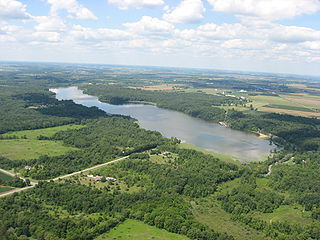
Glacial Lake Wisconsin was a prehistoric proglacial lake that existed from approximately 18,000 to 14,000 years ago, at the end of the last ice age, in the central part of present-day Wisconsin in the United States.

The Driftless Area, also known as Bluff Country and the Paleozoic Plateau, is a topographical and cultural region in the Midwestern United States that comprises southwestern Wisconsin, southeastern Minnesota, northeastern Iowa, and the extreme northwestern corner of Illinois. The Driftless Area is a USDA Level III Ecoregion: Ecoregion 52. The Driftless Area takes up a large portion of the Upper Midwest forest–savanna transition. The Blufflands refers to the eastern section of the Driftless area in Minnesota, due to the steep bluffs and cliffs around the river valleys. The western half is known as the Rochester Plateau, which is flatter than the Blufflands. The Coulee Region refers to the southwestern part of the Driftless Area in Wisconsin. It is named for its numerous ravines.

Interstate Park comprises two adjacent state parks on the Minnesota–Wisconsin border, both named Interstate State Park. They straddle the Dalles of the St. Croix River, a deep basalt gorge with glacial potholes and other rock formations. The Wisconsin park is 1,330 acres (538 ha) and the Minnesota park is 298 acres (121 ha). The towns of Taylors Falls, Minnesota and St. Croix Falls, Wisconsin are adjacent to the park. Interstate Park is within the Saint Croix National Scenic Riverway and the Ice Age National Scientific Reserve. The western terminus of the Ice Age National Scenic Trail is on the Wisconsin side. On the Minnesota side, two areas contain National Park Service rustic style buildings and structures that are listed on the National Register of Historic Places.
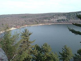
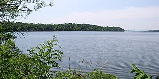
Devil's Lake is a lake in the South Range of the Baraboo Range, about two miles south of Baraboo, Wisconsin, in Sauk County, Wisconsin, United States. It has no surface outlets, so by some definitions, it is endorheic; however, it possibly drains by underground channels into the Baraboo River, which would make the lake cryptorheic. The lake is one of the primary attractions of Devil's Lake State Park. It is also a popular recreation destination for watercraft, fishing, hiking, and climbing.
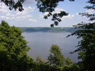
Frontenac State Park is a state park of Minnesota, United States, on the Mississippi River 10 miles (16 km) southeast of Red Wing. The park is notable both for its history and for its birdwatching opportunities. The centerpiece of the park is a 430-foot-high (130 m), 3-mile-long (4.8 km) steep limestone bluff overlooking Lake Pepin, a natural widening of the Mississippi. The bluff is variously called Garrard's Bluff or Point No-Point, the latter name coming from riverboat captains because of the optical illusion that it protruded into the Mississippi River. There is a natural limestone arch on the blufftop called In-Yan-Teopa, a Dakota name meaning "Rock With Opening". Park lands entirely surround the town of Frontenac, once a high-class resort at the end of the 19th century.
Sakatah Lake State Park is an 842-acre (341 ha) state park of Minnesota, USA, on a natural widening of the Cannon River near the town of Waterville. The Dakota native to the area called it "Sakatah" which means "singing hills". To honor this native heritage, some of the trails in the park have been given Dakota names. The Sakatah Singing Hills State Trail, which connects Faribault and Mankato, runs through this park.

The Kettle Moraine State Forest is a state forest in southeastern Wisconsin. The chief feature of the reserve is the Kettle Moraine, a highly glaciated area. The area contains very hilly terrain and glacial landforms, such as kettles, kames and eskers. The 56,000-acre (23,000 ha) forest is divided into two large and three small units, which are spread across a hundred miles.

Willow River State Park is a 2,891-acre (1,170 ha) Wisconsin state park located five miles (8 km) north of Hudson. The centerpiece of the park is Willow Falls, a powerful cascade in a 200-foot (61 m) deep gorge. Another popular feature is Little Falls Lake, a shallow reservoir on the Willow River. Because of its proximity to Minneapolis-St. Paul it is one of the most visited state parks in Wisconsin. Trilobite fossils found in the lower layers of the gorge indicate the rock is around 600 million years old.

Horicon Marsh is a marsh located in northern Dodge and southern Fond du Lac counties of Wisconsin. It is the site of both a national and a state wildlife refuge. The silted-up glacial lake is the largest freshwater cattail marsh in the United States.
Mill Bluff State Park is a state park in west-central Wisconsin, United States. It is located in eastern Monroe and western Juneau counties, near the village of Camp Douglas. A unit of the Ice Age National Scientific Reserve, the park protects several prominent sandstone bluffs 80 feet (24 m) to 200 feet (61 m) high that formed as sea stacks 12,000 years ago in Glacial Lake Wisconsin. As a result, these bluffs are steep and angular, dissimilar to the rounded terrain more typical of the eastern half of the United States. The bluffs served as landmarks to both early pioneers and travelers today on Interstate 90/94, which passes through the park.

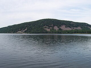
The Baraboo Range is a syncline located in Columbia and Sauk Counties, Wisconsin. It consists of highly eroded Precambrian metamorphic rock. It is about 25 miles (40 km) long and varies from 5 to 10 miles (16 km) in width. The Wisconsin River, previously traveling in a north to south direction, turns to the east just north of the range before making its turn to the west towards the Upper Mississippi River. The eastern end of the range was glaciated during the Wisconsinian glaciation, while the western half was not, and consequently, marks the eastern boundary of Wisconsin's Driftless Area.

Wisconsin, a state in the Midwestern United States, has a vast and diverse geography famous for its landforms created by glaciers during the Wisconsin glaciation 17,000 years ago. The state can be generally divided into five geographic regions—Lake Superior Lowland, Northern Highland, Central Plain, Eastern Ridges & Lowlands, and Western Upland. The southwestern part of the state, which was not covered by glaciers during the most recent ice age, is known as the Driftless Area. The Wisconsin glaciation formed the Wisconsin Dells, Devil's Lake, and the Baraboo Range. A number of areas are protected in the state, including Devil's Lake State Park, the Apostle Islands National Lakeshore, and the Chequamegon–Nicolet National Forest.
Pewit's Nest State Natural Area is a nature reserve in Wisconsin, USA, that includes a deep gorge formed during the retreat of the last glacier. Pewit's Nest is outside Baraboo in Sauk County. At one time a waterwheel and mill were located on the site and an individual lived in the solid sandstone. The name of the site was a result of early settlers calling it "Peewit's Nest" after the abode, ten feet above a deep pool of water, resembling the nest of a phoebe. The water-wheel once turned lathes for repairing or manufacturing equipment, but no evidence of it remains. Pewit's Nest is owned by the Wisconsin Department of Natural Resources and was designated a State Natural Area in 1985.

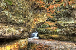
Parfrey's Glen, located within Devil's Lake State Park, is a Wisconsin Department of Natural Resources-designated State Natural Area. The glen is a deep gorge cut through the sandstone of the south flank of the Baraboo Hills. It was the first State Natural Area to be designated in Wisconsin. The valley was named for Robert Parfrey.
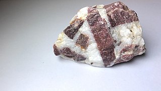
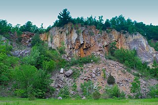
Baraboo Quartzite is a Precambrian geological formation of quartzite, found in the region of Baraboo, Wisconsin. While pure quartzite is usually white or gray, Baraboo Quartzite is typically dark purple to maroon in color, due to the presence of iron (hematite) and other impurities. Baraboo Quartzite may display strata created by progressive deposition of layers of sand in the original sandstone from which the quartzite was formed. Specimens of Baraboo quartzite may also display ripple marks that appear visually similar to the patterns one might see in the sand at a beach. Ripples indicate that the sandstone from which the quartzite was metamorphosed was originally water-laid sediment.

The Southern Unit of the Kettle Moraine State Forest includes more than 22,000 acres of land throughout southern Wisconsin and spans several state parks and natural areas. The area also features varied environments from restored prairie, forests, and lakes, along with providing a multitude of recreational opportunities such as hiking, birdwatching, fishing, camping, and hunting. The Kettle Moraine Scenic Drive also extends within this region as well as through a larger portion of the state.
Kiser Lake Wetlands State Nature Preserve, or simply Kiser Lake Wetlands, is a 51 acres (21 ha) nature reserve located in Johnson Township, Champaign County, Ohio, United States. It is located wholly within the Kiser Lake State Park, and operated by the Ohio Department of Natural Resources.
Ableman's Gorge is a 127 acres (51 ha) Wisconsin State Natural Area located near Rock Springs, Wisconsin. This 200 to 400-foot wide and 200-foot high gorge is cut by about 1 mile (1.6 km) of the Baraboo River in an "L" shape. The Natural Area is named after George Ableman, who settled Rock Springs in 1851 and named the community after the gorge area.
 Southeast moraine between the South Bluff and the East Bluff-South Face
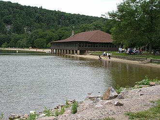 The "Chateau" atop the North Glacial Moraine
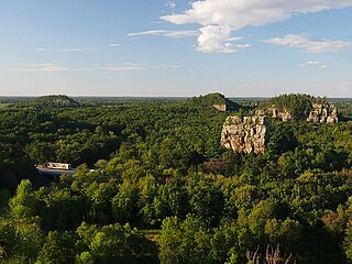
 Eastern View of Devil's Lake from above
 Devil's Doorway rock formation