Divisions of British India

Last updated

1909 British Indian Empire map as appeared in The Imperial Gazetteer of India British Indian Empire 1909 Imperial Gazetteer of India.jpg
1909 British Indian Empire map as appeared in The Imperial Gazetteer of India

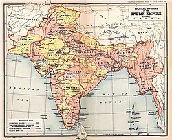
The divisions of British India were the administrative divisions of the Government of the British Raj or the Indian Empire. [1]

Contents

Divisions in Bengal

The seven Bengal Regulation Districts were named as 'divisions' in 1851:

The partition of Bengal in 1905 , there were seven divisions in Bengal :

After the reunited of Bengal in 1911, the boundaries of Bengal were changed and the Bengal were divided five divisions . viz :

Divisions of Eastern Bengal and Assam

The divisions of Eastern Bengal and Assam Province 1905—1912:

Divisions in Baroda

Divisions in Bombay

Divisions in Burma

Divisions in Central India

Divisions in Central Provinces and Berar

Divisions of Hyderabad

Divisions in Rajputana

Divisions in United Provinces

Divisions in Punjab

See also

Related Research Articles

<span class="mw-page-title-main">Bengal</span> Region in the eastern Indian subcontinent

Bengal is a historical geographical, ethnolinguistic and cultural term referring to a region in the eastern part of the Indian subcontinent at the apex of the Bay of Bengal. The region of Bengal proper is divided between modern-day Bangladesh and the Indian state of West Bengal. The Indian states of Assam, Jharkhand, Bihar, Chhattishgarh and Tripura as well as the union territory of Andaman and Nicobar islands have a sizeable Bengali population. A large Bengali diaspora exists across the world. Bengali is the sixth-most spoken language in the world.

<span class="mw-page-title-main">States and union territories of India</span> Indian national administrative subdivisions

India is a federal republic comprising 28 states and 8 union territories. The states and union territories are further subdivided into districts and smaller administrative divisions.

<span class="mw-page-title-main">Dhaka Division</span> Administrative division of Bangladesh

Dhaka Division is an administrative division within Bangladesh. Dhaka serves as the capital city of the Dhaka Division, the Dhaka District and Bangladesh. The division remains a population magnet, covers an area of 20,508.8 km2 with a population in excess of 44 million, It is the most populous country second level division of the world, growing at 1.94% rate since prior count, compared with national average of 1.22%. However, national figures may include data skewing expatriation of male labor force as gender ratio is skewed towards females.

<span class="mw-page-title-main">Central Provinces and Berar</span> Province of British India, and later, Dominion of India (1903–1950)

The Central Provinces and Berar was a province of British India and later the Dominion of India which existed from 1903 to 1950. It was formed by the merger of the Central Provinces with the province of Berar, which was territory leased by the British from the Hyderabad State. Through an agreement signed on 5 November 1902, 6th Nizam Mahbub Ali Khan, Asaf Jah VI leased Berar permanently to the British for an annual payment of 25 lakhs rupees. Lord Curzon decided to merge Berar with the Central Provinces, and this was proclaimed on 17 September 1903.

<span class="mw-page-title-main">Bengal Presidency</span> Province of India

The Bengal Presidency, officially the Presidency of Fort William in Bengal and later Bengal Province, was a province of British India and the largest of all the three Presidencies. At the height of its territorial jurisdiction, it covered large parts of what is now South Asia and Southeast Asia. Bengal proper covered the ethno-linguistic region of Bengal. Calcutta, the city which grew around Fort William, was the capital of the Bengal Presidency. For many years, the Governor of Bengal was concurrently the Governor-General of India and Calcutta was the capital of India until 1911.

<span class="mw-page-title-main">Singhbhum district</span> District of British India of Bengal Presidency

Singhbhum was a district of India during the British Raj, part of the Chota Nagpur Division of the Bengal Presidency. It was located in the present-day Indian state of Jharkhand. Chaibasa was the district headquarters. Located in the southern limit of the Chota Nagpur Plateau, Singhbhum included the Kolhan estate located in its southeastern part. The district has been segmented into two smaller districts, East Singhbhum and West Singhbhum.

<span class="mw-page-title-main">Partition of Bengal (1905)</span> 1905 territorial reorganization of the Bengal Presidency by the British Raj

The first Partition of Bengal (1905) was a territorial reorganization of the Bengal Presidency implemented by the authorities of the British Raj. The reorganization separated the largely Muslim eastern areas from the largely Hindu western areas. Announced on 16 July 1905 by Lord Curzon, then Viceroy of India, and implemented West Bengal for Hindus and East Bengal for Muslims, it was undone a mere six years later. The nationalists saw the partition as a challenge to Indian nationalism and as a deliberate attempt to divide the Bengal Presidency on religious grounds, with a Muslim majority in the east and a Hindu majority in the west. The Hindus of West Bengal complained that the division would make them a minority in a province that would incorporate the province of Bihar and Orissa. Hindus were outraged at what they saw as a "divide and rule" policy, even though Curzon stressed it would produce administrative efficiency. The partition animated the Muslims to form their own national organization along communal lines. To appease Bengali sentiment, Bengal was reunited by King George V in 1911, in response to the Swadeshi movement's riots in protest against the policy.

<span class="mw-page-title-main">Presidencies and provinces of British India</span> 1612–1947 British directly-ruled administrative divisions in India

The provinces of India, earlier presidencies of British India and still earlier, presidency towns, were the administrative divisions of British governance on the Indian subcontinent. Collectively, they have been called British India. In one form or another, they existed between 1612 and 1947, conventionally divided into three historical periods:

<span class="mw-page-title-main">Orissa Tributary States</span> Group of princely states in Odisha, India

The Orissa Tributary States, also known as the Garhjats and as the Orissa Feudatory States, were a group of princely states of British India now part of the present-day Indian state of Odisha.

<span class="mw-page-title-main">Eastern Bengal and Assam</span> Former province of India

Eastern Bengal and Assam was a province of India between 1905 and 1912. Headquartered in the city of Dacca, it covered territories in what are now Bangladesh, Northeast India and Northern West Bengal.

<span class="mw-page-title-main">Agencies of British India</span> Fully- or semi-autonomous administrative region of British India

An agency of British India was an internally autonomous or semi-autonomous unit of British India whose external affairs were governed by an agent designated by the Viceroy of India.

Bihar is a state situated in Eastern India. It is surrounded by West Bengal to the east, Uttar Pradesh to the west, Jharkhand to the south and Nepal to the north.

<span class="mw-page-title-main">Howrah–New Delhi main line</span> Railway line connecting Delhi and Kolkata

The Howrah–New Delhi main line is a railway line connecting Delhi and Kolkata cutting across northern India. The 1,531 km (951 mi) railway line was opened to traffic in 1866 with the introduction of the "1 Down/2 Up Mail" train.

<span class="mw-page-title-main">1934 Indian general election</span>

General elections were held in British India in 1934. The Indian National Congress emerged as the largest party in the Central Legislative Assembly.

<span class="mw-page-title-main">1920 Indian general election</span>

General elections were held in British India in 1920 to elect members to the Imperial Legislative Council and the Provincial Councils. They were the first elections in the country's modern history.

General elections were held in British India in November 1923 for both the Central Legislative Assembly and Provincial Assemblies. The Central Legislative Assembly had 145 seats, of which 105 were elected by the public.

<span class="mw-page-title-main">1926 Indian general election</span>

General elections were held in British India between 28 October and late November 1926 to elect members of the Imperial Legislative Council and the Provincial Legislative Councils.

General elections were held in British India in September 1930. They were boycotted by the Indian National Congress and marked by public apathy. The newly elected Central Legislative Assembly met for the first time on 14 January 1931.

<span class="mw-page-title-main">Districts of British India</span> Districts during the British India period

The Districts of British India were administrative units of the Government of the British Raj or Indian Empire. Districts were generally subdivisions of the provinces and divisions of British India

References

  1. Imperial Gazetteer of India . Published under the authority of His Majesty's Secretary of State for India in Council. Oxford: Clarendon Press, 1907-1909