Downtown Memphis, Tennessee

Last updated
Downtown Memphis as seen from Poplar Avenue Memphis Skyline from Poplar Ave.jpg
Downtown Memphis as seen from Poplar Avenue

Downtown Memphis, Tennessee is the central business district of Memphis, Tennessee and is located along the Mississippi River between Interstate 40 to the north, Interstate 55 to the south and I-240 to the east, where it abuts Midtown Memphis.

Contents

It is home to the Memphis Redbirds, the AAA affiliate of the St. Louis Cardinals, and the Memphis Grizzlies NBA team.

History

The Memphis river landing (1906) Riverboats at Memphis.jpg
The Memphis river landing (1906)

Downtown is the oldest part of the city and includes the riverfront and the bluffs overlooking the Mississippi River. The founders of Memphis dedicated the riverfront to the public "now and forever" as long as the public use continued. The land overlooking the riverfront was originally planned to become a "public promenade" to be called Mississippi Row. The upper riverfront became the site of the river landing where steamboats were loaded with cotton and other goods in the 19th and early 20th centuries. Between 1844 and 1886 the river landing was paved with limestone and granite cobblestones brought in from the upper Midwest. This created what is today the largest intact Mississippi River landing still in existence, and is listed on the National Register of Historic Places. [1] The explosion of the steamboat Sultana in 1865 near Memphis was one of the worst marine disasters in history.

There are several historic residences downtown, particularly in the Victorian Village neighborhood. Other historic homes include the Hunt-Phelan House (1830), the Magevney House (ca. 1835) and the Burkle Estate (1849). The Burkle home and the Hunt Phelan House (533 Beale Street) were reputed to have been part of the underground railroad by which escaped slaves made their way to freedom prior to the Civil War. [2]

Downtown Airport

In 1959, the Memphis Downtown Airport was opened on Mud Island, which at that time was called City Island. The one-runway airport could be reached by a pontoon-boat ferry and was used mostly by businessmen and shoppers. The Downtown Airport was closed in 1970. [3] It was replaced in the 1990s by the new urbanist Harbor Town development.

Overview

Buildings

View west on Madison Avenue, ending with the Customs House (1906) Madison avenue Memphis.jpg
View west on Madison Avenue, ending with the Customs House (1906)

The Downtown Memphis skyline contains the tallest buildings in the city. The tallest building in Memphis, 100 North Main, is located at the heart of downtown along Main Street at Adams Ave and rises to 430 ft (131m). Some notable and/or historic downtown buildings are:

Downtown Memphis consists of 4.5 million square feet (418,000 square meters) of office space, [4] around 1 million square feet (93,000 square meters) of retail space, 3,456 hotel rooms, and 13,400 housing units. [5]

The administrative core of Memphis and Shelby County is also located in Downtown Memphis. These include the Memphis City Hall, and the Federal Building, located on North Main Street, in the Civic Center Plaza (corner of Main Street and Washington). Downtown Memphis also contains the Memphis branch of the Federal Reserve Bank of St. Louis. [6]

Districts and neighborhoods

View from the Peabody Hotel, looking east over Autozone Park toward the Medical District. Autozone Park Memphis TN.jpg
View from the Peabody Hotel, looking east over Autozone Park toward the Medical District.

Downtown Core

Downtown Core is the heart of the central business district and includes the majority of office space, retail, entertainment and dining spaces. [5] It is a popular regional destination for entertainment, dining, and tourism and includes attractions such as Beale Street, FedExForum, AutoZone Park, and the Peabody Hotel.

Districts & neighborhoods

Memphis Riverfront

River Walk at Butler Park Riverwalk Memphis TN 003.jpg
River Walk at Butler Park

Downtown Memphis is located on the banks of the Mississippi River. The Memphis Riverfront stretches from the Meeman-Shelby Forest State Park in the north, to T. O. Fuller State Park in the south.

The River Walk is a park system along the Mississippi River that connects the Mississippi River Greenbelt Park in the north, to Tom Lee Park in the south.

Points of interest along the riverfront

Economy

Companies headquartered in Downtown include:

Former headquarters:

Schools

Downtown Memphis is zoned to the following Shelby County Schools (formerly Memphis City Schools) campuses:

Transportation

Downtown is served by major highways and interstates, public bus and trolley service by MATA, commercial bus service by Greyhound, and passenger train service by Amtrak.

Interstates I-40, I-55, I-69 and I-240 all run directly through downtown, providing direct access to the area from adjacent areas as well as the region as a whole. The new Interstate 22 is about 10 miles away from Downtown. Downtown also serves as the western termination point for U.S. Route 78 as well as U.S. Route 72, and is directly located along U.S. Route 51, U.S. Route 61, U.S. Route 64, U.S. Route 70, and U.S. Route 79.

MATA operates the North End Terminal, its primary hub for Memphis public bus service, at the corner of Main Street and A.W. Willis Avenue. [11] The majority of fixed bus routes operates by MATA terminate at the North End Terminal, therefore bus accessibility in the area is very high. [12]

The MATA Trolley is a heritage streetcar system that operates three lines in downtown along Main Street, Riverside Drive, and Madison Avenue. It consists of twenty four stations and, in 2021, had a daily ridership of approximately 650. [13] Connections between MATA public bus and Main Street trolley line can be made at the North End Terminal.

Amtrak's City of New Orleans passenger train runs through Downtown Memphis three days a week, stopping at Central Station. [14]

Historic views

Related Research Articles

<span class="mw-page-title-main">Memphis, Tennessee</span> City in Tennessee, United States

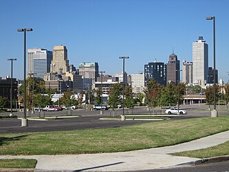
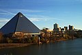
Memphis is a city in the U.S. state of Tennessee. It is the seat of Shelby County, in the southwesternmost part of the state, and is situated along the Mississippi River. With a population of 633,104 at the 2020 U.S. census, Memphis is the second-most populous city in Tennessee after Nashville.

<span class="mw-page-title-main">West Tennessee</span> Geographic and cultural region of Tennessee, United States

West Tennessee is one of the three Grand Divisions of Tennessee that roughly comprises the western quarter of the state. The region includes 21 counties between the Tennessee and Mississippi rivers, delineated by state law. Its geography consists primarily of flat lands with rich soil and vast floodplain areas of the Mississippi River. Of the three regions, West Tennessee is the most sharply defined geographically, and is the lowest-lying. It is both the least populous and smallest, in land area, of the three Grand Divisions. Its largest city is Memphis, the state's second most populous city.

Midtown is a collection of neighborhoods in Memphis, Tennessee, to the east of Downtown.

<span class="mw-page-title-main">Memphis Area Transit Authority</span>

The Memphis Area Transit Authority (MATA) is the public transportation provider for Memphis, Tennessee. It is one of the largest transit providers in the state of Tennessee; MATA transports customers in the City of Memphis and parts of Shelby County on fixed-route buses, paratransit vehicles, demand-responsive service, and the MATA Trolley system. The system is managed by a seven-member policy board appointed by the mayor and approved by the Memphis City Council. In 2023, the system had a ridership of 3,122,700.

<span class="mw-page-title-main">Memphis Central Station</span> Railway station in Memphis, Tennessee

Memphis Central Station, referred to as Grand Central Station prior to 1944, is a passenger terminal in Memphis, Tennessee. Located along Main Street and G.E. Patterson Boulevard in Downtown Memphis, it currently a service stop for Amtrak's City of New Orleans route, arriving in late evening northbound and in the morning southbound. It is also served by the MATA Trolley system. The building was opened in 1914, and is located within the city's South Main Arts District. It is also an contributing property to the South Main Street Historic District of the National Register of Historic Places, as are the National Civil Rights Museum and other historic properties within the district boundaries.

<span class="mw-page-title-main">Sterick Building</span> United States historic place

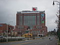
The Sterick Building is an office building in Memphis, Tennessee. It was designed by Wyatt C. Hedrick & Co., and was completed in 1930—its name is a contraction of the original owners' names, R.E. Sterling and Wyatt Hedrick. It is a gothic-style tower, 111 m (365 ft) tall with 29 floors. When it opened it 1930 it was called the tallest building in the American South, It was the tallest building in Tennessee until 1957. It is now the fifth-tallest building in Memphis. It stands at the corner of Madison Avenue and North B.B. King Boulevard.

<span class="mw-page-title-main">Transportation in St. Louis</span>

Transportation in Greater St. Louis, Missouri includes road, rail, ship, and air transportation modes connecting the bi-state St. Louis metropolitan area with surrounding communities throughout the Midwest, national transportation networks, and international locations. The Greater St. Louis region also supports a multi-modal transportation network that includes bus, paratransit, and light rail service in addition to shared-use paths, bike lanes and greenways.

<span class="mw-page-title-main">One Beale</span>

One Beale is a proposed four-phase development in Memphis, Tennessee. Located at the corner of Beale Street and Riverside, the $400 million riverfront development located in downtown Memphis will include high-end apartments, a full-service Hyatt hotel, and space for restaurants and events stretching 5.5 acres from Beale Street to Pontotoc Avenue and along Front Street and west to the Mississippi River. As of October 2020, One Beale had three phases under construction valued at $200 million with another $200 million in the development pipeline.

<span class="mw-page-title-main">Tom Lee Park</span> City park in Memphis, Tennessee

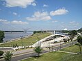
Tom Lee Park is a city park located to the immediate west of downtown Memphis, Tennessee, overlooking the Mississippi River. Encompassing about 30 acres (12 ha) parallel to the Mississippi River for about one mile (1.6 km), it offers panoramic views of the Mississippi River and the shores of Arkansas on the opposite side. The park is named after Tom Lee, an African-American riverworker, who saved the lives of 32 passengers of the sinking steamboat M.E. Norman in 1925.

<span class="mw-page-title-main">History of Memphis, Tennessee</span>

The history of Memphis, Tennessee and its area began many thousands of years ago with succeeding cultures of indigenous peoples. In the first millennium, it was settled by the Mississippian culture. The Chickasaw Indian tribe emerged about the 17th century, or migrated into the area. The earliest European exploration may have encountered remnants of the Mississippian culture by Spanish explorer Hernando de Soto. Later French explorers led by René-Robert Cavelier, Sieur de La Salle likely encountered the Chickasaw. The city of Memphis was not founded until 1819. The city was named after the ancient capital of Egypt on the Nile River in North Africa.

<span class="mw-page-title-main">Tourism in Memphis, Tennessee</span>

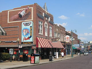
Tourism in Memphis includes the points of interest in Memphis, Tennessee such as museums, fine art galleries, and parks, as well as Graceland the Beale Street entertainment district, and sporting events.

<span class="mw-page-title-main">Transportation in Memphis, Tennessee</span>

Memphis, Tennessee has developed into a major Mid-American commercial and transportation hub because of its location on the Mississippi River and a convergence of numerous rail and highway links. Four rail and highway bridges cross the Mississippi River at Memphis. In addition, Memphis International Airport has become the world's largest airfreight terminal.

<span class="mw-page-title-main">MATA Trolley</span> Streetcar system in Memphis, Tennessee

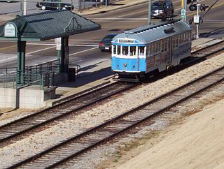
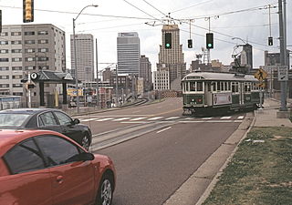
The MATA Trolley is a heritage streetcar transit system operating in Memphis, Tennessee. It began operating on April 29, 1993. Service was suspended in June 2014, following fires on two cars. After nearly four years and repeated postponements, the reopening of the Main Street Line took place on April 30, 2018. The system's two other lines remained suspended as of December 2022, but with reopening of both planned. In 2023, the system had a ridership of 365,400.

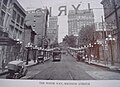
The Memphis Street Railway Company was a privately owned operator of streetcars (trams) and trolleybuses in Memphis, Tennessee on roughly 160 route miles of overhead electrified cable and rails between 1895 and 1960. The longest of the rail lines reached from downtown to Memphis National Cemetery near Raleigh.

<span class="mw-page-title-main">Main Street Line (MATA Trolley)</span>

The Main Street Line is a line of the Memphis Area Transit Authority trolley system. It began operations in 1993, becoming the first streetcar line to operate in Memphis since 1947. It runs for about 2 mi (3.2 km) along Main Street, with 14 stops in Downtown Memphis. The Main Street Line is concurrent with the Riverfront Loop for almost all of its length.

<span class="mw-page-title-main">Riverfront Loop</span> Trolley line in Memphis, Tennessee

The Riverfront Loop is a line of the Memphis Area Transit Authority trolley system. It began operation in 1997, as the second line in the system. It runs for 4.1 mi (6.6 km) through downtown Memphis and along the Mississippi riverfront, with 18 stops along the way. It is the longest of the system's three lines, though it is concurrent with the Main Street Line for about half of its length. Part of the line offers panoramic views of the Mississippi River from atop to the Chickasaw Bluffs.

<span class="mw-page-title-main">Madison Avenue Line (MATA Trolley)</span> Line of the Memphis Area Transit Authority trolley system

The Madison Avenue Line is a line of the Memphis Area Transit Authority trolley system. The trolley line began operating in 2004, and cost $56 million to build. It consists of 2.2 mi (3.5 km) of double track along Madison Avenue with six stops stretching into Midtown Memphis. The line was built to connect the Main Street system to the Medical District just east of Downtown Memphis. Trolley service has been suspended since April 2014, after two trolley cars caught fire within a span of six months. Buses have been serving the line since then, but MATA plans to restore trolley operation to the line eventually.

<span class="mw-page-title-main">Mississippi River Trail</span> Long-distance bicycle route

The Mississippi River Trail is a designated bicycle and pedestrian trail that traverses the shores of the Mississippi River in the United States. The trail extends from the headwaters at Lake Itasca in Minnesota to near the mouth of the river in Venice, Louisiana. Much of the trail’s 3,000 miles (4,800 km) follows roadways used by motor vehicles, although some of the route is on multi-use trails. The segment in Minnesota has been designated as U.S. Bicycle Route 45, part of the U.S. Bicycle Route System.

<span class="mw-page-title-main">Pinch District, Memphis</span>

The Pinch District is a historical district of downtown Memphis roughly bordered by the Wolf River lagoon on the west, Market Street on the south, Danny Thomas Boulevard on the east, and A.W. Willis Avenue on the north.

The Memphis River Parks Partnership (MRPP), known as the Riverfront Development Corporation (RDC) until being renamed in April 2018, is a nonprofit organization that manages and develops the various riverfront parks and amenities located along the Mississippi River in Memphis, Tennessee, on behalf of the city government.

References

  1. http://river.freshbits.com/library/2000/05/on-memphis-waterfront-master-plan-must.html Clubb, Deborah M. On the Memphis Waterfront: Master Plan Must Account for What the Founders Wanted: A Public Promenade Commercial Appeal, Sunday, May 21, 2000.
  2. Hunt-Phelann House. Archived March 13, 2010, at the Wayback Machine
  3. Bond, Beverly G.; Sherman, Janann (2003). Memphis: In Black & White. Memphis: Arcadia Publishing. p. 160. ISBN   0-7385-2441-7.
  4. "Memphis MarketBeats | United States". Cushman & Wakefield. Retrieved March 15, 2021.
  5. 1 2 "Downtown Memphis: Demographics". Archived from the original on December 21, 2010. Retrieved February 14, 2011.
  6. "Federal Reserve Bank of St. Louis | Memphis Branch". Retrieved October 17, 2013
  7. Memphis' Confederate Parks Renamed: City Drops 3 Names That Honor Racist Past Reuters
  8. "Store Support Center." AutoZone. Retrieved on June 4, 2013.
  9. "Contact Us Archived 2014-10-04 at the Wayback Machine ." Southern Airways Express. Retrieved on November 21, 2014. "Southern Airways Express One Commerce Square, 21st Floor P.O. Box 3088 Memphis, TN 38173"
  10. Risher, Wayne. "Pinnacle's decision to move Downtown lifts hopes for other development." The Commercial Appeal . October 8, 2010. Retrieved on October 8, 2010.
  11. "MataTransit | Memphis, TN". www.matatransit.com. Archived from the original on December 5, 2008. Retrieved May 22, 2022.
  12. "MATA-System_Map_Nov20.pdf" (PDF). MATA Memphis Area Transit Authority. Archived (PDF) from the original on January 17, 2021. Retrieved February 4, 2021.
  13. "Monthly Module Raw Data Release". www.transit.dot.gov. Retrieved April 5, 2022.
  14. "City of New Orleans Train Chicago, Memphis, New Orleans | Amtrak". www.amtrak.com. Retrieved February 4, 2021.

35°08′20″N90°03′27″W / 35.1389°N 90.0575°W / 35.1389; -90.0575