Cordova, Tennessee

Last updated

Cordova, Tennessee
Cordova TN Farms Flowers Fellowship sign.jpg
Cordova Farms Flowers Fellowship sign
Coordinates: 35°09′20″N89°46′34″W / 35.15556°N 89.77611°W / 35.15556; -89.77611
Country United States
State Tennessee
County Shelby
City Memphis (majority)
Settledc. 1835
Area
  Total8.019 sq mi (20.77 km2)
Elevation
361 ft (110 m)
Population
 (2020)
  Total68,779
 Census Bureau American Community Survey
Time zone UTC-6 (CST)
  Summer (DST) UTC-5 (CDT)
ZIP code
38016, 38018, 38088
Area code 901
FIPS code 12-38250 [1]
GNIS feature ID1281298 [2]

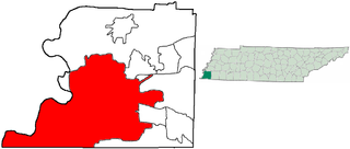
Cordova [3] [4] [5] [6] is a community in Shelby County, Tennessee, United States. Cordova lies east of Memphis, north of Germantown, south of Bartlett, and northwest of Collierville at an elevation of 361 feet (110 meters).

Contents

The majority of Cordova has been annexed by the City of Memphis. The remainder of Cordova is in unincorporated Shelby County, within the Memphis Annexation Reserve area. [7] The boundaries of the Cordova community are inexact, but are generally regarded as the Wolf River on the south, Whitten Road on the west, Interstate 40 on the north, and Pisgah Road on the east.[ citation needed ] Parts of Shelby Farms are considered part of Cordova.[ citation needed ]The Old Cordova Area is centered on Macon and Sanga Roads, about a mile and a half east of Germantown Road.[ citation needed ]It consists of the former town of Cordova, with some of the original structures still present. The Wolfchase Area is not actually a part of Cordova, but is often referred to as part of the Cordova area by association.[ citation needed ] It contains major shopping centers, businesses and apartments.

Early history

Cordova was a farming village east of Memphis with fewer than a dozen farms when it was founded in 1835. Cordova was renowned for the freshly cut flowers that were shipped to Memphis, Tennessee, thus the town's motto was "Farms, Flowers and Fellowship". [8] [9]

Cordova has changed its name several times. Originally, it was known as Allentown, then Marysville, then Dexter.[ citation needed ] In 1888, the Dexter post office was opened. In 1900, the name was changed to Cordova.[ citation needed ] The town most likely changed its name to "Cordova" so not to be confused with another town named Dexter that was located on the same NC&St.L railroad line that ran through town.

Railroad heritage

Cordova Train Station Cordova TN old train station 2.jpg
Cordova Train Station

Cordova was one of the many small railroad stops along the Nashville, Chattanooga and St. Louis Railway route to Memphis, Tennessee. The original station which was built in 1889 is still standing. It is located on the corner of Macon Rd. and B St. in downtown. A train named the City of Memphis from Nashville to Memphis stopped at the former Cordova Railroad station (this station is still standing and has been sold to an individual who is renovating it so it can be utilized as a retail business). An important ammunition plant was near Cordova and was served by the railroad during World War II. [10]

Cordova has a railroad line running parallel to the main street (now Macon Road) that was served by P&M (Paducah & Memphis) division of the N. C. & St. L. Railroad (Nashville, Chattanooga & St Louis) that was chartered in Tennessee on December 11, 1845. In March 1957 N.C. & St. L. was taken over by the L & N Railroad (Louisville and Nashville). Because of this, the rail line was considered redundant and the mileage between Cordova and Jackson, Tennessee was abandoned and later scrapped in 1968. The remaining section was therefore made a spur line for the L&N, and later the CSX until 2002, when it was taken out of service. In 2008, this section of railroad was removed. An extension of the Shelby Farms Greenline was completed to the old railroad station in 2016 with future plans to extend it to Houston Levee Road.

Annexation

After a seven-year court challenge to the right of Memphis to annex, portions of Cordova were annexed into the Memphis City Council Second District. These included the subdivisions and land developments of Countrywood (1995), Berryhill (1997), and South Cordova (2001). However, these areas of Cordova were not annexed by Memphis in the years as planned, since they were annexed in the latter years. In response to this, Countrywood was annexed into the city in May 2002, after a failed attempt annexation in 1995. [11] After several court and legislative challenges, Memphis completed its annexation of the Cordova region with the subdivision of Rockcreek, along U.S. 64 to the Fayette County line. [12] [13]

South Cordova and Rocky Point de-annexation

In 2012, the South Cordova area was annexed by Memphis, and de-annexed in early 2021. [14] To respond to the de-annexation of South Cordova, Memphis had plans to annex the area in 2001, but decided to put it on hold for unknown reasons. [15] The Rocky Point area, which is part of Cordova, is centered north of Walnut Grove Road between the alignment of Forest Hill and Rocky Point Road. On January 1, 2021, the area was de-annexed by Memphis, and the area returned to unincorporated status. [16]

Today

Cordova grew from a quiet country farm hamlet with a population of 150 people in 1912 to one of the fastest growing neighborhoods of Memphis. Retail growth exploded in the late 1990s thanks to the Wolfchase Galleria shopping mall, which at the time was the largest retail center in unincorporated Shelby County outside of the Memphis city limits. Today the majority of the growth is along Houston Levee Road and Macon Road as well as major retail and commercial centers on Germantown Parkway. There are now over 1,226 businesses with over 19,400 employees working in Cordova. As of 2020, Cordova has a population of 68,779. [17]

Cordova continues to preserve its past with a historic downtown which each year celebrates with an annual crafts fair and having its own Fourth of July parade. [18] [19] The community is home of the Hope Presbyterian Church, a megachurch with average weekly attendance of over 7,500. [20] In 2005 the church scaled down plans for a $50 million auditorium with a bell tower that would reach to 180 feet after protests from local homeowners, but opened a smaller facility with 5,000 seats in December 2007. [21]

In 2010, the area's Heartsong Church gained national attention for opening its doors and welcoming the local Muslim population. The worshipers used this space during the month of Ramadan while the Memphis Islamic Center was being built. There were no protests, contrasting with other areas at the time including the proposed Islamic center in New York, and mosque in Murfreesboro, Tennessee. [22] [23]

Cordova is home to a branch of the Memphis Public Library system. The Cordova Branch Library started in one room at the old train depot on Macon Road before moving to the 1913 community center on Sanga Road. In 2004, the branch moved to its own building on Trinity Road.

Bert Ferguson Community Center, located on Trinity Road, is the current site of community athletic fields and rooms, walking trail, banquet hall, and educational development.

Notable people

Historic places

Cordova School, now the Community Center Cordova TN old schoolhouse NRHP 3.jpg
Cordova School, now the Community Center

Education

Cordova is zoned to Memphis-Shelby County Schools. Until the 2013 merger of Memphis City Schools and Shelby County schools, Cordova was divided between the two districts. [27]

Cordova Schools:

Portions are zoned to Germantown Middle School and Germantown High School, which are not part of the municipal school system of Germantown. [27]

Private schools

Higher education

Demographics

Historical population
CensusPop.Note
1980 36,126
1990 39,5449.5%
2000 55,87541.3%
2010 52,264−6.5%
2017 (est.)60,76216.3%

As of the 2010 Census, there were 78,138 people, 31,403 households, and 20,760 families living in the 38018 and 38016 zip codes which comprise Cordova. The area includes 33,515 housing units. The racial makeup of the area was 61.5% White, 29.2% African American, 0.29% Native American, 4.99% Asian, 0.065% Pacific Islander, and 2.48% from other races, and 2.1% from two or more races. Hispanic or Latino of any race were 5.47% of the population.

Of households in the area, 32.66% had children under the age of 18 living with them, 49.18% were married couples living together, 12.7% had a female householder with no husband present, and 33.89% were non-family households. 27.41% of all households were made up of individuals, and 4.95% had someone living alone who was 65 years of age or older. The median age was 34.5 years.

The median household income in zip code 38018 was $67,437 and the median income for a family was $82,319. In zip code 38016, the median household income was $64,190 and the median family income was $80,736. The per capita income was $34,806 in 38018 and $32,590 in 38016. About 5% of families and about 6.9% of the total population were below the poverty line, including about 10% of those under age 18 and about 6% of those age 65 and over.

Recreation

See also

Related Research Articles

<span class="mw-page-title-main">Shelby County, Tennessee</span> County in Tennessee, United States

Shelby County is the westernmost county in the U.S. state of Tennessee. As of the 2020 census, the population was 929,744. It is the largest of the state's 95 counties, both in terms of population and geographic area. Its county seat is Memphis, a port on the Mississippi River and the second most populous city in Tennessee. The county was named for Governor Isaac Shelby (1750–1826) of Kentucky. It is one of only two remaining counties in Tennessee with a majority African American population, along with Haywood County.

<span class="mw-page-title-main">Olive Branch, Mississippi</span> City in Mississippi, United States

Olive Branch is the 6th most populous city in Mississippi, US, located in DeSoto County. At the 2020 census the population was 39,711. Olive Branch is part of the Memphis Metropolitan Statistical Area, a region that consists of three counties in southwest Tennessee, five counties in northwest Mississippi, and two counties in eastern Arkansas. Olive Branch was the fastest-growing city in the United States, with a growth rate of 838% as of 2010 in a thirty year time frame. Along with other rapidly growing places in DeSoto County, Olive Branch attributes most of its growth and development to the exodus of large numbers of families from central Memphis.

<span class="mw-page-title-main">Bartlett, Tennessee</span> City in Tennessee, United States

Bartlett is a city in Shelby County, Tennessee, United States. The population was 57,786 at the 2020 U.S. Census.

<span class="mw-page-title-main">Germantown, Tennessee</span> City in Tennessee, United States

Germantown is a city in Shelby County, Tennessee, United States. The population was 41,333 at the 2020 census.

A county island is a small or large portion of an unincorporated area that is within the jurisdiction of a county, usually surrounded by adjacent areas that are incorporated into a municipality. On maps, these geopolitical anomalies will form jagged or complex borders and 'holes' in the city limits. Generally found more frequently in the western United States, county islands form in areas of expansion when previously smaller cities will annex and incorporate more land into their jurisdiction. If residents or landowners in a particular unincorporated area do not vote to incorporate with the surrounding city, the area remains unincorporated. The formation of a county island usually follows stages where it will come into being on the edge of an incorporated area, and as more territory is incorporated, be cut off from the rest of the unincorporated area within the county. These areas are not actually exclaves by definition, because they are simply unincorporated outside of a surrounding city.

Whitehaven, informally known as "Blackhaven", is a predominantly African-American community in Memphis, Tennessee, United States. It was first organized in the late 19th century as a neighborhood for upper-class families. Its current population is about 50,000.

<span class="mw-page-title-main">Frayser, Memphis</span> Neighborhood in Memphis, Tennessee, United States

Frayser is a neighborhood on the north side of Memphis, Tennessee, United States. It is named after Memphis physician Dr. J Frayser, who owned a summer home near the railroad. Frayser's boundaries are the Wolf River to the south, the Mississippi River to the west, the Loosahatchie River to the north, and ICRR tracks to the east. The population of Frayser is approximately 45,000.

<span class="mw-page-title-main">Cordova High School (Tennessee)</span> High school in the United States

Cordova High School is a public high school located in Cordova, Tennessee, United States, within unincorporated Shelby County, to the east of the city of Memphis, and is also part of the Memphis-Shelby County Schools district.

Raleigh is a community in north-central Memphis, Tennessee, United States, named for a formerly incorporated town that used to be at its center. Raleigh is bordered on the west by the community of Frayser, on the east by the incorporated suburb of Bartlett, on the south by the Wolf River and Interstate 40, and on the north by the Memphis city limits. The former town of Raleigh was the first county seat of Shelby County, Tennessee.

Raleigh-Egypt High School (REHS) is a secondary school located at 3970 Voltaire Road in Raleigh, a section of Memphis, Tennessee, United States. It is part of the Shelby County Schools district. It shares a campus with Egypt Central Elementary School and Raleigh-Egypt Middle School. The high school has an enrollment of 595 as of school year 2019–2020.

<span class="mw-page-title-main">Memphis City Schools</span> Former school district in Tennessee, United States

Memphis City Schools (MCS) was the school district operating public schools in the city of Memphis, Tennessee, United States. It was headquartered in the Frances E. Coe Administration Building. On March 8, 2011, residents voted to disband the city school district, effectively merging it with the Shelby County School District. The merger took effect July 1, 2013. After much legal maneuvering, all six incorporated municipalities created separate school districts in 2014. Total enrollment, as of the 2010-2011 school year, was about 103,000 students, which made the district the largest in Tennessee.

East Memphis is a region of Memphis, Tennessee with several defined and informal subdivisions and neighborhoods such as Colonial Acres, White Station-Yates, Sherwood Forest, Normal Station, High Point Terrace, Belle Meade, Normandy Meadows, St. Nick, Pleasant Acres, Balmoral, and Ridgeway. The general boundaries are informal:

<span class="mw-page-title-main">Tennessee State Route 177</span> State highway in Tennessee, United States

State Route 177 is a secondary state highway in Shelby County, Tennessee. The majority of the route is known as Germantown Road and Germantown Parkway.
<span class="mw-page-title-main">Geography of Memphis, Tennessee</span>

The City of Memphis is located on the eastern bank of the Mississippi River in the southwest corner of the U.S. state of Tennessee. It is the regional hub for a tri-state area of Arkansas, Mississippi and Tennessee.

Brunswick is an unincorporated community in Shelby County, Tennessee, United States. Brunswick is 7.5 miles (12.1 km) northeast of the center of Bartlett. Since the town is unincorporated, the boundaries are not officially defined, but it is roughly bounded by the Loosahatchie River to the north, Oliver Creek on the east, U.S. Route 70 to the south, and Germantown Road/Craven Road to the west. Initially, Brunswick was a separate community that formed along the Louisville and Nashville Railroad. Many of the same families have lived in Brunswick for multiple generations. Many of these families are buried in Pleasant Hill Cemetery on Brunswick Road, between the railroad tracks and U.S. Route 70.

Eads is an unincorporated community in Shelby County, Tennessee, United States, named after Civil War engineer James Buchanan Eads. Some parts of Eads have been annexed by the city of Memphis. Some of its area is currently still unincorporated. Eads is located north of Collierville, west of Somerville, east of Memphis and Bartlett. The Eads zip code (38028) stretches into both Shelby County and Fayette County, including parts of Hickory Withe and Fisherville. Major roads in the community include Winfield Dunn Parkway, U.S. Route 64, Collierville-Arlington Road/Airline Road, and Seward Road.

Southwind is an unincorporated and gated community located on the southeastern portion of Shelby County, Tennessee, United States, and part of the Memphis metropolitan area. Since the area is a part of Shelby County, it sits unincorporated on the southeast boundary of the Memphis city limits, in the Memphis annexation reserve area. The area's boundaries are one section of the 38125 zip code bounded by Winchester Road, Germantown, and Hacks Cross Road and include the PGA Tour Southwind golf course - TPC Southwind, home of The World Golf Championship. According to the 2010 census, the Southwind area population was 36,150, with 75% African American, 4% Asian, 15% Non-Hispanic White, and 6% Hispanic. The majority of households with children residing in them had both a father and mother in the home. For families in Southwind the median income was $72,587 and the mean income was $85,975.

<span class="mw-page-title-main">Lakeland School System</span>

The Lakeland School System (LSS) is a municipal school district serving the city of Lakeland, Tennessee, United States, within Greater Memphis. Lakeland Elementary School and Lakeland Preperatory School are within the district.

Boxtown is a neighborhood in South Memphis, Memphis, Tennessee near T.O. Fuller State Park. The oldest section of South Memphis, Boxtown includes White's Chapel AME Church, built in 1890. Boxtown has numerous shotgun houses.

References

  1. "U.S. Census website". United States Census Bureau . Retrieved 2008-01-31.
  2. "US Board on Geographic Names". United States Geological Survey. October 25, 2007. Retrieved 2008-01-31.
  3. "Shelby County Home Sales Heating Up Before Summer" . Retrieved 2017-12-27.
  4. "With new ramp and stairs, Perkins area has access to Greenline" . Retrieved 2017-12-27.
  5. "Cordova killing marks Shelby County's 17th homicide in 2016". December 22, 2016. Retrieved 2017-12-27.
  6. Baker, Jackson. "GOP's Vaughan Wins Special Election for House District 95" . Retrieved 2017-12-27.
  7. "Annexation Reserve Areas: 3 & 5 mile radius". ShelbyCountyTnGov. November 2010.
  8. Darlene Hooker Sawyer; Jane Howles Hooker (2013). Cordova. Arcadia Publishing. ISBN   9781467110013.
  9. Robert W. Dye (2005). Shelby County. Arcadia Publishing. ISBN   9780738541921.
  10. "Cordova Train Depot - N.C.&St.L - Cordova, Tn - Train Stations/Depots on Waymarking.com". www.waymarking.com. Retrieved 2017-12-27.
  11. "Home". www.countrywood.org. Retrieved 2023-06-09.
  12. "Annexations by the City of Memphis with Ordinance and Study Area Numbers, 1819-2006" . Retrieved 2017-12-27.
  13. "Memphis looks at seven areas for de-annexation" . Retrieved 2017-12-27.
  14. Mandy Hrach (January 1, 2021). "Memphis is shrinking: South Cordova, other areas de-annexed; no longer part of city limits". Fox 13.
  15. "Annexation and Coordinates 1827-2007 Shelby County" . Retrieved 2021-07-11.
  16. "Deannexation Update | Southwind-Windyke, S. Cordova, Rocky Point Video Brief". City of Memphis. August 14, 2020. Archived from the original on 2020-12-22. Retrieved 2021-08-06.
  17. "Cordova, TN Complete Guide [2021] | What is Living in Cordova Memphis Like?". Big League Movers. October 15, 2020. Retrieved 2021-09-01.
  18. "News". Mid-South Horse Review. June 14, 2005. Archived from the original on 2014-07-15.
  19. "Rancho Cordova Fourth of July". www.enutshells.net. Cordova Community Council. Archived from the original on 2017-12-28. Retrieved 2017-12-27.
  20. "Top 100 Largest Churches". 2008 The Outeach 100. Archived from the original on 2011-07-16. Retrieved 2010-08-10.
  21. James Dowd (December 22, 2007). "Hope Presbyterian holiday events offer preview of new sanctuary". The Commercial Appeal . Retrieved 2010-08-10.
  22. Adam Rose (September 8, 2010). "Lead By Example: Amid Quran Controversy, Church Partners With Islamic Center". Huffington Post.
  23. "Heartsong Church in Cordova has 'open doors' for Muslim neighbors". Archived from the original on 2011-11-21. Retrieved 2013-04-02.
  24. "Daly's wife gives birth to a 6-pound girl". Tampa Bay Times. October 11, 2005. Retrieved 2021-05-04.
  25. "What to do in Memphis for the Fourth of July" . Retrieved 2017-12-27.
  26. "National Register of Historic Places" . Retrieved 2017-12-27.
  27. 1 2 Dries, Bill (March 10, 2014). "Cordova Parents Question Attendance Zone Changes". Memphis Daily News . Archived from the original on 2014-03-11. Retrieved 2014-03-11.