The Greater Richmond, Virginia area has many neighborhoods and districts.
Midtown is a collection of neighborhoods in Memphis, Tennessee, to the east of Downtown.
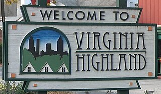
Virginia–Highland is a neighborhood of Atlanta, Georgia, founded in the early 20th century as a streetcar suburb. It is named after the intersection of Virginia Avenue and North Highland Avenue, the heart of its trendy retail district at the center of the neighborhood. The neighborhood is famous for its bungalows and other historic houses from the 1910s to the 1930s. It has become a destination for people across Atlanta with its eclectic mix of restaurants, bars, and shops as well as for the Summerfest festival, annual Tour of Homes and other events.
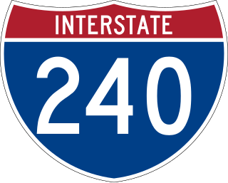
Interstate 240 (I-240) is a 19.27-mile-long (31.01 km) auxiliary Interstate Highway in the US state of Tennessee that forms a bypass around the southern and eastern neighborhoods of Memphis. Combined, I-240 and its parent, I-40, form a contiguous beltway around most of Memphis. I-240 runs from I-40 in Midtown Memphis to I-40 and Sam Cooper Boulevard in East Memphis. Throughout its length, it provides access to I-55, multiple U.S. and state routes, and the Memphis International Airport. The segment between the western terminus and I-55 is a north–south route, and the segment between I-55 and the eastern terminus runs east to west. Throughout its length, I-240 is designated as the Dr. Martin Luther King Jr. Expressway, the W.B. Fowler Sr. Expressway, and the Avron B. Fogelman Expressway.

Lake Street is a major east-west thoroughfare between 29th and 31st streets in Minneapolis, Minnesota United States. From its western most end at the city's limits, Lake Street reaches the Chain of Lakes, passing over a small channel linking Bde Maka Ska and Lake of the Isles, and at its eastern most end it reaches the Mississippi River. In May 2020, the Lake Street corridor suffered extensive damage during local unrest following the murder of George Floyd. In August of the same year, city officials designated East Lake Street as one of seven cultural districts to promote racial equity, preserve cultural identity, and promote economic growth.

Overton Park is a large, 342-acre (138 ha) public park in Midtown Memphis, Tennessee. The park grounds contain the Memphis Brooks Museum of Art, Memphis Zoo, a 9-hole golf course, the Memphis College of Art, Rainbow Lake, Veterans Plaza, the Greensward, and other features. The Old Forest Arboretum of Overton Park, one of the few remaining old growth forests in Tennessee, is a natural arboretum with labeled trees along trails.

East Memphis is a region of Memphis, Tennessee with several defined and informal subdivisions and neighborhoods such as Colonial Acres, White Station-Yates, Sherwood Forest, Normal Station, High Point Terrace, Belle Meade, Normandy Meadows, St. Nick, Pleasant Acres, Balmoral, and Ridgeway. The general boundaries are informal:
Columbus, the state capital and Ohio's largest city, has numerous neighborhoods within its city limits. Neighborhood names and boundaries are not officially defined. They may vary or change from time to time due to demographic and economic variables.

Ponce de Leon Avenue, often simply called Ponce, provides a link between Atlanta, Decatur, Clarkston, and Stone Mountain, Georgia. It was named for Ponce de Leon Springs, in turn from explorer Juan Ponce de León, but is not pronounced as in Spanish. Several grand and historic buildings are located on the avenue.

Mid-City is a neighborhood of the city of New Orleans. A sub-district of the Mid-City District Area, its boundaries as defined by the New Orleans City Planning Commission are: City Park Avenue, Toulouse Street, North Carrollton, Orleans Avenue, Bayou St. John and St. Louis Street to the north, North Broad Street to the east, and the Pontchartrain Expressway to the west. It is a historic district on the National Register of Historic Places. In 2023, the neighborhood was cited as one of the "coolest" in the world by Time Out. In common usage, a somewhat larger area surrounding these borders, usually the areas bounded by the beltway formed by Interstates 10 and 610, is often also referred to as part of Mid-City.
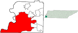
The City of Memphis is located on the eastern bank of the Mississippi River in the southwest corner of the U.S. state of Tennessee. It is the regional hub for a tri-state area of Arkansas, Mississippi and Tennessee.

This is a list of the National Register of Historic Places listings in Detroit, Michigan.
Vollintine Hills Historic District is a historic district located in the Midtown area of Memphis, Tennessee, notable for its cohesive collection of 78 post-World War II Minimal Traditional and ranch-style houses built around a former synagogue. "The neighborhood represents the efforts of members of an Orthodox religious group to accommodate their beliefs by developing a synagogue and housing for the congregation within easy walking distance."

Sam Cooper Boulevard is an urban highway in Memphis, Tennessee, United States. The more recent western segment of the road follows a parkway design, while the older eastern portion, which was proposed and constructed as a segment of Interstate 40 (I-40), was built as a freeway, without at-grade intersections and traffic lights. The western terminus of Sam Cooper Boulevard is at East Parkway North. At the western terminus, there is a short concurrency of East Parkway North with U.S. Route 64 (US 64), US 70, and US 79. From its western end, Sam Cooper Boulevard runs east for 5.8 miles (9.3 km) to reach its eastern terminus at the I-40/I-240 interchange.

Binghampton is a neighborhood on an edge of Midtown in Memphis, Tennessee. It is named after W. H. Bingham, an Irish immigrant, hotelier, planter, magistrate, politician, and entrepreneur who founded a town to the east and slightly north of the Memphis city limits in 1893.

The Memphis Parkway System is a system of parkways that formed the original outer beltway around Memphis, Tennessee. They consist of South Parkway, East Parkway, and North Parkway. Designed by George Kessler, the Parkway System connects Martin Luther King Jr. Riverside Park with Overton Park. The system was put on the National Register of Historic Places on July 3, 1989.
Little Rock, Arkansas is home to numerous neighborhoods. See List of Little Rock Neighborhoods for an exhaustive list.

McAdams is a neighborhood in Wichita, Kansas, United States. A mixed industrial and residential area northeast of Downtown Wichita, it is a historical center of the city's African American community.


