Durham (CDP), New Hampshire

Last updated

Durham, New Hampshire
Main Street, Durham NH.jpg
Main Street
USA New Hampshire location map.svg
Red pog.svg
Durham
Usa edcp location map.svg
Red pog.svg
Durham
Coordinates: 43°8′1″N70°55′31″W / 43.13361°N 70.92528°W / 43.13361; -70.92528
Country United States
State New Hampshire
County Strafford
Town Durham
Area
[1]
  Total3.08 sq mi (7.98 km2)
  Land3.02 sq mi (7.84 km2)
  Water0.06 sq mi (0.15 km2)
Elevation
60 ft (20 m)
Population
 (2020)
  Total11,147
  Density3,684.96/sq mi (1,422.65/km2)
Time zone UTC-5 (Eastern (EST))
  Summer (DST) UTC-4 (EDT)
ZIP code
03824
Area code 603
FIPS code 33-19620
GNIS feature ID2378059

Durham is a census-designated place (CDP) and the main village in the town of Durham in Strafford County, New Hampshire, United States. The population of the CDP was 11,147 at the 2020 census, [2] out of 15,490 in the entire town. The CDP is home to the University of New Hampshire.

Contents

Geography

The CDP is in the northern part of the town of Durham, on the north side of the Oyster River. It is bordered to the north by the town of Madbury. The western edge of the CDP follows the Pan Am Railways line, Reservoir Brook, Spinney Lane, Mast Road, and a portion of College Brook, then turns west and south through College Woods. The southern border of the CDP follows the Oyster River as far as Beards Creek, which it follows north to New Hampshire Route 108. The border then follows U.S. Route 4 east to Johnson Creek, the eastern edge of the CDP. [3]

U.S. Route 4 passes through the northern part of the CDP, bypassing the town center. Route 4 leads southeast 9 miles (14 km) to Interstate 95 in Portsmouth and west 34 miles (55 km) to Concord, the state capital. Route 108 passes through the center of the CDP, leading north 5 miles (8 km) to the center of Dover and south 12 miles (19 km) to Exeter. The campus of the University of New Hampshire occupies the southwestern part of the CDP.

According to the U.S. Census Bureau, the Durham CDP has a total area of 3.1 square miles (8.0 km2), of which 3.0 square miles (7.8 km2) are land and 0.06 square miles (0.15 km2), or 1.83%, are water. [4]

Demographics

Historical population
CensusPop.Note
1950 4,172
1960 4,68812.4%
1970 7,22154.0%
1980 8,44817.0%
1990 9,2369.3%
2000 9,024−2.3%
2010 10,34514.6%
2020 11,1477.8%
U.S. Decennial Census [5]

The demographics of the Durham CDP are strongly influenced by the presence of the University of New Hampshire campus. As of the census of 2010, there were 10,345 people, 1,669 households, and 642 families residing in the CDP. There were 1,727 housing units, of which 58, or 3.4%, were vacant. The racial makeup of the CDP was 93.1% white, 1.0% African American, 0.1% Native American, 3.6% Asian, 0.02% Pacific Islander, 0.5% some other race, and 1.6% from two or more races. 2.3% of the population were Hispanic or Latino of any race. [6]

6,328 people in the CDP lived in group quarters such as dormitories rather than in households. Of the 1,669 households in the CDP, 16.1% had children under the age of 18 living with them, 32.7% were headed by married couples living together, 4.1% had a female householder with no husband present, and 61.5% were non-families. 29.2% of all households were made up of individuals, and 8.8% were someone living alone who was 65 years of age or older. The average household size was 2.41, and the average family size was 2.85. [6]

4.6% of residents in the CDP were under the age of 18, 78.3% were from age 18 to 24, 5.4% were from 25 to 44, 7.0% were from 45 to 64, and 4.7% were 65 years of age or older. The median age was 20.5 years. For every 100 females, there were 83.2 males. For every 100 females age 18 and over, there were 81.9 males. [6]

For the period 2011-15, the estimated median annual income for a household was $48,083, and the median income for a family was $111,875. Male full-time workers had a median income of $61,250 versus $51,696 for females. The per capita income for the CDP was $15,807. 35.9% of the population and 2.8% of families were below the poverty line, along with 1.4% of people under the age of 18 and 10.8% of people 65 or older. [7]

Related Research Articles

<span class="mw-page-title-main">Suncook, New Hampshire</span> Census-designated place in New Hampshire, United States

Suncook is a census-designated place (CDP) in Merrimack County, New Hampshire, United States. The population was 5,501 at the 2020 census. Approximately two-thirds of Suncook is located in the town of Pembroke, with the remainder in Allenstown.

<span class="mw-page-title-main">Winchester (CDP), New Hampshire</span> Census-designated place in New Hampshire, United States

Winchester is a census-designated place (CDP) and the main village in the town of Winchester in Cheshire County, New Hampshire, United States. The population of the CDP was 1,606 at the 2020 census, compared to 4,150 in the entire town.

Gorham is a census-designated place (CDP) and the main village in the town of Gorham in Coos County, New Hampshire, United States. The population of the CDP was 1,851 at the 2020 census, out of 2,698 people in the entire town of Gorham.

Whitefield is a census-designated place (CDP) and the main village in the town of Whitefield in Coos County, New Hampshire, United States. The population of the CDP was 1,460 at the 2020 census, out of 2,490 people in the entire town of Whitefield.

<span class="mw-page-title-main">Bristol (CDP), New Hampshire</span> Census-designated place in New Hampshire, United States

Bristol is a census-designated place (CDP) and the main village in the town of Bristol in Grafton County, New Hampshire, United States. The population of the CDP was 1,911 at the 2020 census, out of 3,244 in the entire town.

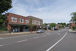
Hanover is a census-designated place (CDP) and the main village in the town of Hanover in Grafton County, New Hampshire, United States. The population of the CDP was 9,078 at the 2020 census, out of 11,870 in the entire town. The CDP includes the campus of Dartmouth College.

<span class="mw-page-title-main">Plymouth (CDP), New Hampshire</span> Census-designated place in New Hampshire, United States

Plymouth is a census-designated place (CDP) and the main village in the town of Plymouth in Grafton County, New Hampshire, United States. Its population was 4,730 at the 2020 census, out of 6,682 in the entire town. The CDP includes the campus of Plymouth State University.

<span class="mw-page-title-main">Greenville (CDP), New Hampshire</span> Census-designated place in New Hampshire, United States

Greenville is a census-designated place (CDP) and the main village in the town of Greenville in Hillsborough County, New Hampshire, United States. The population of the CDP was 1,074 at the 2020 census, out of 1,974 in the entire town.

<span class="mw-page-title-main">Hillsborough (CDP), New Hampshire</span> Census-designated place in New Hampshire, United States

Hillsborough is a census-designated place (CDP) and the main village in the town of Hillsborough in Hillsborough County, New Hampshire, United States. The population of the CDP was 2,156 at the 2020 census, out of 5,939 in the entire town.

<span class="mw-page-title-main">Milford (CDP), New Hampshire</span> Census-designated place in New Hampshire, United States

Milford is a census-designated place (CDP) and the main village in the town of Milford, Hillsborough County, New Hampshire, United States. The population of the CDP was 9,212 at the 2020 census, out of 16,131 in the entire town.

<span class="mw-page-title-main">Exeter (CDP), New Hampshire</span> Census-designated place in New Hampshire, United States

Exeter is a census-designated place (CDP) and the main village in the town of Exeter, Rockingham County, New Hampshire, United States. The population of the CDP was 10,109 at the 2020 census, out of 16,049 in the entire town.

<span class="mw-page-title-main">Hampton (CDP), New Hampshire</span> Census-designated place in New Hampshire, United States

Hampton is a census-designated place (CDP) comprising the town center and surrounding developed areas of the town of Hampton, Rockingham County, New Hampshire, United States. The population of the CDP was 9,597 at the 2020 census, out of 16,214 in the entire town.

<span class="mw-page-title-main">Londonderry (CDP), New Hampshire</span> Census-designated place in New Hampshire, United States

Londonderry is a census-designated place (CDP) within the town of Londonderry in Rockingham County, New Hampshire, United States. The population of the CDP was 11,645 at the 2020 census, out of 25,826 in the entire town.

<span class="mw-page-title-main">Newmarket (CDP), New Hampshire</span> Census-designated place in New Hampshire, United States

Newmarket is a census-designated place (CDP) and the main village in the town of Newmarket in Rockingham County, New Hampshire, United States. The population of the CDP was 5,797 at the 2020 census, out of 9,430 in the entire town.

<span class="mw-page-title-main">Farmington (CDP), New Hampshire</span> Census-designated place in New Hampshire, United States

Farmington is a census-designated place (CDP) and the main village in the town of Farmington, Strafford County, New Hampshire, United States. The population of the CDP was 3,824 at the 2020 census, out of 6,722 in the entire town.

<span class="mw-page-title-main">Goffstown (CDP), New Hampshire</span> Census-designated place in New Hampshire, United States

Goffstown is a census-designated place (CDP) and the main village in the town of Goffstown in Hillsborough County, New Hampshire, United States. The population of the CDP was 3,366 at the 2020 census, out of 18,577 in the entire town.

<span class="mw-page-title-main">Newfields (CDP), New Hampshire</span> Census-designated place in New Hampshire, United States

Newfields is a census-designated place (CDP) and the main village within the town of Newfields, Rockingham County, New Hampshire, United States. The population of the CDP was 378 at the 2020 census, out of 1,769 in the entire town.

<span class="mw-page-title-main">Seabrook Beach, New Hampshire</span> Census-designated place in New Hampshire, United States

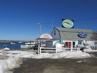
Seabrook Beach is a census-designated place in the town of Seabrook and partially in the town of Hampton in Rockingham County, New Hampshire, United States. It had a population of 1,078 at the 2020 census.

<span class="mw-page-title-main">Ashland (CDP), New Hampshire</span> Census-designated place in New Hampshire, United States

Ashland is a census-designated place (CDP) and the main village in the town of Ashland in Grafton County, New Hampshire, United States. The population of the CDP was 1,082 at the 2020 census, out of 1,938 in the entire town.

<span class="mw-page-title-main">Colebrook (CDP), New Hampshire</span> Census-designated place in New Hampshire, United States

Colebrook is a census-designated place (CDP) and the main village in the town of Colebrook, Coös County, New Hampshire, United States. The population of the CDP was 1,201 at the 2020 census, out of 2,084 in the entire town. The CDP population had dropped from 1,394 at the 2010 census.

References

  1. "ArcGIS REST Services Directory". United States Census Bureau. Retrieved September 20, 2022.
  2. "Durham CDP, New Hampshire: 2020 DEC Redistricting Data (PL 94-171)". U.S. Census Bureau. Retrieved January 5, 2022.
  3. "TIGERweb: Durham CDP, New Hampshire". Geography Division, U.S. Census Bureau. Retrieved January 26, 2021.
  4. "2021 U.S. Gazetteer Files – New Hampshire". United States Census Bureau. Retrieved January 5, 2022.
  5. "Decennial Census Official Publications". Census.gov. Retrieved March 4, 2024.
  6. 1 2 3 "Profile of General Population and Housing Characteristics: 2010 Census Summary File 1 (DP-1): Durham CDP, New Hampshire". American Factfinder. U.S. Census Bureau. Archived from the original on February 13, 2020. Retrieved October 5, 2017.
  7. "Selected Economic Characteristics: 2011-2015 American Community Survey 5-Year Estimates (DP03): Durham CDP, New Hampshire". American Factfinder. U.S. Census Bureau. Archived from the original on February 13, 2020. Retrieved October 5, 2017.