Barrington, New Hampshire

Last updated

Barrington, New Hampshire
Town
Tom Ham Brook, Barrington, NH.jpg
Tom Ham Brook c. 1910
BarringtonSeal.jpg
Strafford-Barrington-NH.png
Location within Strafford County, New Hampshire
Coordinates: 43°13′22″N71°02′49″W / 43.22278°N 71.04694°W / 43.22278; -71.04694
Country United States
State New Hampshire
County Strafford
Settled 1699
Incorporated 1722
Villages
  • Barrington
  • East Barrington
  • West Barrington
Government
   Select Board
  • Joyce Cappiello, Chair
  • James Saccoccia, Vice Chair
  • Dannen Mannschreck
  • Robert Gibson
  • Tracy Hardekopf
  Town AdministratorConner MacIver
Area
[1]
  Total48.6 sq mi (125.9 km2)
  Land46.6 sq mi (120.8 km2)
  Water2.0 sq mi (5.1 km2)
Elevation
381 ft (116 m)
Population
 (2020) [2]
  Total9,326
  Density200/sq mi (77.2/km2)
Time zone UTC-5 (EST)
  Summer (DST) UTC-4 (EDT)
ZIP code
03825
Area code 603
FIPS code 33-03460
GNIS feature ID0873538
Website www.barrington.nh.gov

Barrington is a town in Strafford County, New Hampshire, United States. The population was 9,326 at the 2020 census, [2] up from 8,576 at the 2010 census. [3] The town is a woodland, farm and commuter town.

Contents

History

Barrington was incorporated in 1722 and named for Samuel Shute of Barrington Hall, colonial governor of Massachusetts and New Hampshire. His brother was John Shute Barrington, 1st Viscount Barrington.

The town was made up of two grants, the first containing all of Strafford and present-day Barrington except for a parcel two miles (3.2 km) wide called New Portsmouth, or the Two Mile Streak. This second grant had been set aside to provide fuel and home sites for imported workers at the Lamprey River Iron Works, chartered in 1719 by the Massachusetts General Court to encourage industrial development in the province.

Slow at first to be settled because of rocky soil, Barrington by 1810 had 3,564 residents, then the state's third largest town, its primary industry the smelting of iron ore. The Isinglass River, together with its tributaries, provided water power for grist, fulling and saw mills. In 1820, Strafford was set off from Barrington, reducing its land area by about half, because of lengthy travel required to attend town meetings.

In 1882, the Reverend Alonzo Hall Quint wrote:

"Of those towns in the state whose scenery is somewhat quiet, one of the most beautiful is Barrington."

Indeed, the town's attractive natural features, including rivers, brooks, waterfalls and not less than 14 ponds, are summarized by the name of a 374-foot (114 m) summit, Beauty Hill. Barrington is bisected by the Calef Highway (New Hampshire Route 125), named for a state senator from the 1800s whose family also founded in 1869 a locally famous general store that remains in operation.

Geography

According to the United States Census Bureau, the town has a total area of 48.6 square miles (125.9 km2), of which 46.6 square miles (120.8 km2) are land and 2.0 square miles (5.1 km2) are water, comprising 4.05% of the town. [1] Barrington is drained by the Isinglass River and Bellamy River. Swains Lake and Mendum's Pond are in the south. The highest point in town is an unnamed summit near its western border, measuring 610 feet (190 m) above sea level. The highest named summit is Bumfagging Hill, at 601 ft (183 m). Barrington lies fully within the Piscataqua River (Coastal) watershed. [4]

The commercial center of town is the village of East Barrington, centered on the junction of state routes 9 and 125.

Adjacent municipalities

Demographics

Historical population
CensusPop.Note
1790 2,470
1800 2,77312.3%
1810 3,56428.5%
1820 1,610−54.8%
1830 1,89517.7%
1840 1,845−2.6%
1850 1,752−5.0%
1860 1,96312.0%
1870 1,581−19.5%
1880 1,497−5.3%
1890 1,408−5.9%
1900 1,208−14.2%
1910 900−25.5%
1920 616−31.6%
1930 613−0.5%
1940 78027.2%
1950 1,05234.9%
1960 1,036−1.5%
1970 1,86580.0%
1980 4,404136.1%
1990 6,16440.0%
2000 7,47521.3%
2010 8,57614.7%
2020 9,3268.7%
U.S. Decennial Census [2] [5]
Old Post Office (East Barrington) c. 1910 Old Post Office, East Barrington, NH.jpg
Old Post Office (East Barrington) c.1910

As of the census [6] of 2000, there were 7,475 people, 2,756 households, and 2,075 families residing in the town. The population density was 160.5 inhabitants per square mile (62.0/km2). There were 3,147 housing units at an average density of 67.6 per square mile (26.1/km2). The racial makeup of the town was 98.11% White, 0.25% African American, 0.13% Native American, 0.41% Asian, 0.05% Pacific Islander, 0.23% from other races, and 0.80% from two or more races. Hispanic or Latino of any race were 0.92% of the population.

There were 2,756 households, out of which 38.8% had children under the age of 18 living with them, 64.6% were married couples living together, 6.5% had a female householder with no husband present, and 24.7% were non-families. 16.9% of all households were made up of individuals, and 4.3% had someone living alone who was 65 years of age or older. The average household size was 2.71 and the average family size was 3.07.

Winkley's Pond c. 1915 Winkleys Pond, Barrington, NH.jpg
Winkley's Pond c.1915

In the town, the population was spread out, with 27.5% under the age of 18, 5.7% from 18 to 24, 35.1% from 25 to 44, 24.7% from 45 to 64, and 7.0% who were 65 years of age or older. The median age was 37 years. For every 100 females, there were 104.1 males. For every 100 females age 18 and over, there were 101.7 males.

The median income for a household in the town was $50,630, and the median income for a family was $56,136. Males had a median income of $39,098 versus $27,956 for females. The per capita income for the town was $21,012. About 3.6% of families and 5.5% of the population were below the poverty line, including 7.0% of those under age 18 and none of those age 65 or over.

Education

The Barrington School District serves town children from Pre-K through grade 8, at the Early Childhood Learning Center (ECLC), Barrington Elementary School and the Barrington Middle School. Students of high school age attend schools in neighboring communities, including Dover High School, Coe-Brown Northwood Academy, Oyster River High School or St. Thomas Aquinas High School.

Notable people

See also

Related Research Articles

<span class="mw-page-title-main">Strafford County, New Hampshire</span> County in New Hampshire, United States

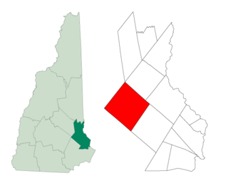
Strafford County is a county in the U.S. state of New Hampshire. As of the 2020 census, the population was 130,889. Its county seat is Dover. Strafford County was one of the five original counties identified for New Hampshire in 1769. It was named after William Wentworth, 2nd Earl of Strafford in the mistaken belief that he was the ancestor of governor John Wentworth – although they were distantly related, William had no descendants. The county was organized at Dover in 1771. In 1840, the size of the original county was reduced with the creation of Belknap County.

<span class="mw-page-title-main">Alford, Massachusetts</span> Town in Massachusetts, United States

Alford is a town in Berkshire County, Massachusetts, United States. It is part of the Pittsfield, Massachusetts Metropolitan Statistical Area. The population was 486 at the 2020 census.

<span class="mw-page-title-main">Barnstead, New Hampshire</span> Town in New Hampshire, United States

Barnstead is a town in Belknap County, New Hampshire, United States. The population was 4,915 at the 2020 census, up from 4,593 at the 2010 census. Home to the Suncook Lakes, Barnstead includes the villages of Center Barnstead, Barnstead Parade and South Barnstead.

<span class="mw-page-title-main">Brookfield, New Hampshire</span> Town in New Hampshire, United States

Brookfield is a town in Carroll County, New Hampshire, United States. The population was 755 at the 2020 census.

<span class="mw-page-title-main">Effingham, New Hampshire</span> Town in New Hampshire, United States

Effingham is a town in Carroll County, New Hampshire, United States. At the 2020 census, the town population was 1,691, up from 1,465 at the 2010 census. Effingham includes the villages of Effingham Falls, Effingham, Center Effingham, and South Effingham. Pine River State Forest is in the south.

<span class="mw-page-title-main">Stewartstown, New Hampshire</span> Town in New Hampshire, United States

Stewartstown is a town in Coös County, New Hampshire, United States. The population was 813 at the 2020 census, down from 1,004 at the 2010 census. It includes the village of West Stewartstown and is part of the Berlin, NH-VT Micropolitan Statistical Area.

<span class="mw-page-title-main">Stratford, New Hampshire</span> Town in New Hampshire, United States

Stratford is a town located on the Connecticut River in Coös County, New Hampshire, United States. The population was 662 at the 2020 census, a decline from the figure of 746 tabulated in 2010. Within the town are the villages of North Stratford, Stratford Hollow, and Beatties. U.S. Route 3 passes through the center of town, as does the St. Lawrence and Atlantic Railroad, formerly a part of the Grand Trunk Railway.

<span class="mw-page-title-main">Brookline, New Hampshire</span> Town in New Hampshire, United States

Brookline is a town in Hillsborough County, New Hampshire, United States. The population was 5,639 at the 2020 census, up from 4,991 at the 2010 census. Brookline is home to the Talbot-Taylor Wildlife Sanctuary, Potanipo Pond, and the Brookline Covered Bridge.

<span class="mw-page-title-main">Northwood, New Hampshire</span> Place in New Hampshire, United States

Northwood is a town in Rockingham County, New Hampshire, United States. The population was 4,641 at the 2020 census.

<span class="mw-page-title-main">Nottingham, New Hampshire</span> Town in New Hampshire, United States

Nottingham is a town in Rockingham County, New Hampshire, United States. The population was 5,229 at the 2020 census, up from 4,785 at the 2010 census. It is the location of Pawtuckaway State Park.

<span class="mw-page-title-main">Dover, New Hampshire</span> City in New Hampshire, United States

Dover is a city in Strafford County, New Hampshire, United States. The population was 32,741 at the 2020 census, making it the most populous city in the New Hampshire Seacoast region and the 5th most populous city in New Hampshire.

<span class="mw-page-title-main">Lee, New Hampshire</span> Town in New Hampshire, United States

Lee is a town in Strafford County, New Hampshire, United States. The population was 4,520 at the 2020 census. The town is a rural farm and bedroom community, being close to the University of New Hampshire.

<span class="mw-page-title-main">Madbury, New Hampshire</span> Town in New Hampshire, United States

Madbury is a town in Strafford County, New Hampshire, United States. The population was 1,918 at the 2020 census.

<span class="mw-page-title-main">Middleton, New Hampshire</span> Town in New Hampshire, United States

Middleton is a town in Strafford County, New Hampshire, United States. The population was 1,823 at the 2020 census.

<span class="mw-page-title-main">Milton, New Hampshire</span> Town in New Hampshire, United States

Milton is a town in Strafford County, New Hampshire, United States. The population was 4,482 at the 2020 census. A manufacturing, resort and residential town, Milton includes the village of Milton Mills. The primary village in town, where 593 people resided at the 2020 census, is defined as the Milton census-designated place (CDP), and is located along New Hampshire Route 125 and the Salmon Falls River, just north of Route 75.

<span class="mw-page-title-main">New Durham, New Hampshire</span> Town in New Hampshire, United States

New Durham is a town in Strafford County, New Hampshire, United States. The population was 2,693 at the 2020 census. It is drained by the Merrymeeting, Cocheco and Ela rivers, and is known for Merrymeeting Lake. New Durham is home to the Powder Mill Fish Hatchery, located on Merrymeeting Road. Also located here is the Lions Club's Camp Pride, a camp for children and adults with special needs.

<span class="mw-page-title-main">Rollinsford, New Hampshire</span> Town in New Hampshire, United States

Rollinsford is a town in Strafford County, New Hampshire, United States. The population was 2,597 at the 2020 census. The main village in town was once known as "Salmon Falls Village".

<span class="mw-page-title-main">Strafford, New Hampshire</span> Town in New Hampshire, United States

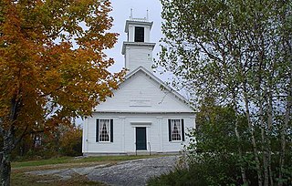
Strafford is a town in Strafford County, New Hampshire, United States. The population was 4,230 at the 2020 census. The two main settlements in town are Center Strafford and Bow Lake Village.

<span class="mw-page-title-main">Strafford, Vermont</span> Town in Vermont, United States

Strafford is a town in Orange County, Vermont, United States. The population was 1,094 at the 2020 census. The town of Strafford was created on August 12, 1761 by way of a royal charter which King George III of Great Britain issued to Governor Benning Wentworth of New Hampshire. The town was named after the Earl of Strafford. Its town house is one of the most famous in Vermont, sitting atop a hill at the end of the historic town common.

<span class="mw-page-title-main">Farmington, New Hampshire</span> Town in New Hampshire, United States

Farmington is a town in Strafford County, New Hampshire, United States. The population was 6,722 at the 2020 census. Farmington is home to Blue Job State Forest, the Tebbetts Hill Reservation, and Baxter Lake.

References

  1. 1 2 "2021 U.S. Gazetteer Files – New Hampshire". United States Census Bureau. Retrieved November 10, 2021.
  2. 1 2 3 "Barrington town, Strafford County, New Hampshire: 2020 DEC Redistricting Data (PL 94-171)". U.S. Census Bureau. Retrieved November 10, 2021.
  3. United States Census Bureau, U.S. Census website, 2010 Census figures. Retrieved March 23, 2011.
  4. Foster, Debra H.; Batorfalvy, Tatianna N.; Medalie, Laura (1995). Water Use in New Hampshire: An Activities Guide for Teachers. U.S. Department of the Interior and U.S. Geological Survey.
  5. "Census of Population and Housing". Census.gov. Retrieved June 4, 2016.
  6. "U.S. Census website". United States Census Bureau . Retrieved January 31, 2008.

Further reading