Middleton, New Hampshire

Last updated

Middleton, New Hampshire
Town
MiddletonNH TownHall March2020.jpg
Historic Middleton Town Hall in 2020
Strafford-Middleton-NH.png
Location within Strafford County, New Hampshire
Coordinates: 43°28′41″N71°04′17″W / 43.47806°N 71.07139°W / 43.47806; -71.07139
Country United States
State New Hampshire
County Strafford
Settled 1749
Incorporated 1778
VillageMiddleton Corners
Government
   Board of Selectmen
  • Roxanne TuftsKeegan, Chair
  • Scott Ferguson
  • Tracy DonovanLaviolette
  • Michael Green
  • Timothy Cremmen
Area
[1]
  Total18.5 sq mi (47.9 km2)
  Land18.1 sq mi (46.8 km2)
  Water0.4 sq mi (1.1 km2)
Elevation
770 ft (230 m)
Population
 (2020)
  Total1,823
  Density101/sq mi (38.9/km2)
Time zone UTC-5 (EST)
  Summer (DST) UTC-4 (EDT)
ZIP code
03887
Area code 603
FIPS code 33-47700
GNIS feature ID0873664
Website www.middletonnh.gov

Middleton is a town in Strafford County, New Hampshire, United States. The population was 1,823 at the 2020 census. [2]

Contents

History

Granted by the Masonian Proprietors in 1749, the town was named after Sir Charles Middleton, 1st Baron Barham, who was in charge of convoy service between Barbados and the colonies. The land was first settled shortly before the Revolutionary War by settlers from Lee and Rochester. Soon after the war, its population was challenged when a number of Quaker families led by the town auditor, Nicholas Austin, left for the more peaceful setting of Austin, Quebec. Although the soil is rocky and unsuited for cultivation, cider was made in considerable quantities, and maple syrup to some extent. [3]

Middleton was situated on the road between the New Hampshire Seacoast and Wolfeboro, the location of colonial governor John Wentworth's summer home, "Kingswood". (Today the road survives as "Governors Road" in northern Rochester and Milton and continues as "Kings Highway" through Middleton. [4] ) Neglect of the road caused the governor to bill the proprietors for repairs he had to make for safe travel to Kingswood, built in 1771. Middleton was incorporated on March 4, 1778, and originally included Brookfield, which was split off in December 1794. [5]

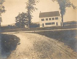
Middleton's old Town Hall, located on King's Highway, was built in 1795 as a meetinghouse on Ridge Road. It was moved to its current location in 1812, jacked-up on the new site, and the Town Hall added underneath. The original stucco painting, a wrap-around landscape mural of trees and scenery, was painted by John Avery in 1811 and touched up in 1841. [6]

Middle Town, New Hampshire, from 1755 map Middleton NH 1755, from Library of Congress map.png
Middle Town, New Hampshire, from 1755 map

Geography

According to the United States Census Bureau, the town has a total area of 18.5 square miles (47.9 km2), of which 18.1 square miles (46.8 km2) are land and 0.42 square miles (1.1 km2) are water, comprising 2.33% of the town. That water is primarily contained by Sunrise Lake, previously known as the Old Dump Reservoir, near the southern corner of the town. Sunrise Lake drains south toward the Cocheco River in Farmington, while the rest of the town drains eastward toward the Branch River, a tributary of the Salmon Falls River. Jones Brook flows through the center of town and joins the Branch River in the northern part of Milton. The entire town is part of the Piscataqua River watershed. The Moose Mountains, which separate Middleton from Brookfield, have a series of 1,600-to-1,700-foot (490 to 520 m) peaks, including the highest point in Middleton at an elevation of 1,670 feet (510 m) above sea level.

The town is served by New Hampshire Route 153.

Adjacent municipalities

Demographics

Historical population
CensusPop.Note
1790 617
1800 431−30.1%
1810 4391.9%
1820 4829.8%
1830 56216.6%
1840 483−14.1%
1850 476−1.4%
1860 53011.3%
1870 476−10.2%
1880 355−25.4%
1890 207−41.7%
1900 30044.9%
1910 291−3.0%
1920 174−40.2%
1930 1761.1%
1940 23634.1%
1950 2558.1%
1960 34936.9%
1970 43023.2%
1980 73470.7%
1990 1,18361.2%
2000 1,44021.7%
2010 1,78323.8%
2020 1,8232.2%
U.S. Decennial Census [7]

As of the census [8] of 2000, there were 1,440 people, 514 households, and 389 families residing in the town. The population density was 79.6 inhabitants per square mile (30.7/km2). There were 706 housing units at an average density of 39.0 per square mile (15.1/km2). The racial makeup of the town was 98.54% White, 0.14% African American, 0.21% Native American, 0.56% Asian, and 0.56% from two or more races. Hispanic or Latino of any race were 0.35% of the population.

There were 514 households, out of which 38.1% had children under the age of 18 living with them, 63.0% were married couples living together, 6.6% had a female householder with no husband present, and 24.3% were non-families. 16.5% of all households were made up of individuals, and 3.9% had someone living alone who was 65 years of age or older. The average household size was 2.80 and the average family size was 3.13.

In the town, the population was spread out, with 28.8% under the age of 18, 6.5% from 18 to 24, 34.1% from 25 to 44, 20.3% from 45 to 64, and 10.3% who were 65 years of age or older. The median age was 37 years. For every 100 females, there were 110.8 males. For every 100 females age 18 and over, there were 106.4 males.

The median income for a household in the town was $43,942, and the median income for a family was $48,529. Males had a median income of $32,014 versus $26,336 for females. The per capita income for the town was $18,415. About 4.5% of families and 7.3% of the population were below the poverty line, including 5.6% of those under age 18 and 6.3% of those age 65 or over.

Related Research Articles

<span class="mw-page-title-main">Strafford County, New Hampshire</span> County in New Hampshire, United States

Strafford County is a county in the U.S. state of New Hampshire. As of the 2020 census, the population was 130,889. Its county seat is Dover. Strafford County was one of the five original counties identified for New Hampshire in 1769. It was named after William Wentworth, 2nd Earl of Strafford in the mistaken belief that he was the ancestor of governor John Wentworth – although they were distantly related, William had no descendants. The county was organized at Dover in 1771. In 1840, the size of the original county was reduced with the creation of Belknap County.

<span class="mw-page-title-main">Sanbornton, New Hampshire</span> Town in New Hampshire, United States

Sanbornton is a town in Belknap County, New Hampshire, United States. The population was 3,026 at the 2020 census. It includes the villages of North Sanbornton and Gaza.

<span class="mw-page-title-main">Brookfield, New Hampshire</span> Town in New Hampshire, United States

Brookfield is a town in Carroll County, New Hampshire, United States. The population was 755 at the 2020 census.

<span class="mw-page-title-main">Wakefield, New Hampshire</span> Town in New Hampshire, United States

Wakefield is a town in Carroll County, New Hampshire, United States. The population was 5,201 at the 2020 census. The town includes the villages of Wakefield Corner, East Wakefield, North Wakefield, Sanbornville, Union, Woodman and Province Lake. Wakefield Corner, popular with tourists, is a picturesque hilltop village of antique buildings. The state of Maine forms the eastern border of Wakefield.

<span class="mw-page-title-main">Dummer, New Hampshire</span> Town in New Hampshire, United States

Dummer is a town in Coös County, New Hampshire, United States. The population was 306 at the 2020 census. It is part of the Berlin, NH–VT micropolitan statistical area. Dummer is home to the Pontook Reservoir, popular with canoeists, kayakers and birdwatchers. In the western part of Dummer lies the village of Paris.

<span class="mw-page-title-main">Hebron, New Hampshire</span> Town in New Hampshire, United States

Hebron is a town in Grafton County, New Hampshire, United States. The population was 632 at the 2020 census. Settlements include the town center and the village of East Hebron.

<span class="mw-page-title-main">Piermont, New Hampshire</span> Town in New Hampshire, United States

Piermont is a town in Grafton County, New Hampshire, United States. The population was 769 at the 2020 census. It is home to Camp Walt Whitman and Kingswood Camp for Boys.

<span class="mw-page-title-main">Brookline, New Hampshire</span> Town in New Hampshire, United States

Brookline is a town in Hillsborough County, New Hampshire, United States. The population was 5,639 at the 2020 census, up from 4,991 at the 2010 census. Brookline is home to the Talbot-Taylor Wildlife Sanctuary, Potanipo Pond, and the Brookline Covered Bridge.

<span class="mw-page-title-main">Epsom, New Hampshire</span> Town in New Hampshire, United States

Epsom is a town in Merrimack County, New Hampshire, United States. The population was 4,834 at the 2020 census.

<span class="mw-page-title-main">Barrington, New Hampshire</span> Town in New Hampshire, United States

Barrington is a town in Strafford County, New Hampshire, United States. The population was 9,326 at the 2020 census, up from 8,576 at the 2010 census. The town is a woodland, farm and commuter town.

<span class="mw-page-title-main">Madbury, New Hampshire</span> Town in New Hampshire, United States

Madbury is a town in Strafford County, New Hampshire, United States. The population was 1,918 at the 2020 census.

<span class="mw-page-title-main">Milton, New Hampshire</span> Town in New Hampshire, United States

Milton is a town in Strafford County, New Hampshire, United States. The population was 4,482 at the 2020 census. A manufacturing, resort and residential town, Milton includes the village of Milton Mills. The primary village in town, where 593 people resided at the 2020 census, is defined as the Milton census-designated place (CDP), and is located along New Hampshire Route 125 and the Salmon Falls River, just north of Route 75.

<span class="mw-page-title-main">New Durham, New Hampshire</span> Town in New Hampshire, United States

New Durham is a town in Strafford County, New Hampshire, United States. The population was 2,693 at the 2020 census. It is drained by the Merrymeeting, Cocheco and Ela rivers, and is known for Merrymeeting Lake. New Durham is home to the Powder Mill Fish Hatchery, located on Merrymeeting Road. Also located here is the Lions Club's Camp Pride, a camp for children and adults with special needs.

<span class="mw-page-title-main">Strafford, New Hampshire</span> Town in New Hampshire, United States

Strafford is a town in Strafford County, New Hampshire, United States. The population was 4,230 at the 2020 census. The two main settlements in town are Center Strafford and Bow Lake Village.

<span class="mw-page-title-main">Wolfeboro, New Hampshire</span> Town in New Hampshire, United States

Wolfeboro is a town in Carroll County, New Hampshire, United States. The population was 6,416 at the 2020 census. A resort area situated beside Lake Winnipesaukee, Wolfeboro includes the village of Wolfeboro Falls.

<span class="mw-page-title-main">Farmington (CDP), New Hampshire</span> Census-designated place in New Hampshire, United States

Farmington is a census-designated place (CDP) and the main village in the town of Farmington, Strafford County, New Hampshire, United States. The population of the CDP was 3,824 at the 2020 census, out of 6,722 in the entire town.

<span class="mw-page-title-main">Farmington, New Hampshire</span> Town in New Hampshire, United States

Farmington is a town in Strafford County, New Hampshire, United States. The population was 6,722 at the 2020 census. Farmington is home to Blue Job State Forest, the Tebbetts Hill Reservation, and Baxter Lake.

<span class="mw-page-title-main">Union, New Hampshire</span> Census-designated place in New Hampshire, United States

Union is a village and census-designated place (CDP) in the town of Wakefield, Carroll County, New Hampshire, United States. It had a population of 196 at the 2020 census.

<span class="mw-page-title-main">Milton Mills, New Hampshire</span> Census-designated place in New Hampshire, United States

Milton Mills is a small village and census-designated place in the town of Milton, Strafford County, New Hampshire, United States. It had a population of 313 at the 2020 census. Milton Mills has a separate ZIP code (03852) from the rest of the town of Milton.

Milton is a census-designated place (CDP) and the primary village in the town of Milton, Strafford County, New Hampshire, United States. The population of the CDP was 593 at the 2020 census, out of 4,482 in the entire town.

References

  1. "2021 U.S. Gazetteer Files – New Hampshire". United States Census Bureau. Retrieved January 5, 2022.
  2. "Census - Geography Profile: Middleton town, Strafford County, New Hampshire" . Retrieved December 24, 2021.
  3. Coolidge, Austin J.; John B. Mansfield (1859). A History and Description of New England. Boston, Massachusetts: A.J. Coolidge. p.  580.
  4. Google Maps
  5. History of Middleton, New Hampshire (1882)
  6. "About Middleton". Town of Middleton. Retrieved January 20, 2015.
  7. "Census of Population and Housing". Census.gov. Retrieved June 4, 2016.
  8. "U.S. Census website". United States Census Bureau . Retrieved January 31, 2008.
Town Hall in 1907 Town Hall, Middleton, NH.jpg
Town Hall in 1907