Strafford County is a county in the U.S. state of New Hampshire. As of the 2020 census, the population was 130,889. Its county seat is Dover. Strafford County was one of the five original counties identified for New Hampshire in 1769. It was named after William Wentworth, 2nd Earl of Strafford in the mistaken belief that he was the ancestor of governor John Wentworth – although they were distantly related, William had no descendants. The county was organized at Dover in 1771. In 1840, the size of the original county was reduced with the creation of Belknap County.

Belknap County is a county in the U.S. state of New Hampshire. As of the 2020 census, the population was 63,705. The county seat is Laconia. It is located in New Hampshire's Lakes Region, slightly southeast of the state's geographic center. Belknap County comprises the Laconia, NH Micropolitan Statistical Area, which in turn constitutes a portion of the Boston-Worcester-Providence, MA-RI-NH-CT Combined Statistical Area.

Hebron is a town in Grafton County, New Hampshire, United States. The population was 632 at the 2020 census. Settlements include the town center and the village of East Hebron.

Northwood is a town in Rockingham County, New Hampshire, United States. The population was 4,641 at the 2020 census.
Barrington is a town in Strafford County, New Hampshire, United States. The population was 9,326 at the 2020 census, up from 8,576 at the 2010 census. The town is a woodland, farm and commuter town.

Milton is a town in Strafford County, New Hampshire, United States. The population was 4,482 at the 2020 census. A manufacturing, resort and residential town, Milton includes the village of Milton Mills. The primary village in town, where 593 people resided at the 2020 census, is defined as the Milton census-designated place (CDP), and is located along New Hampshire Route 125 and the Salmon Falls River, just north of Route 75.
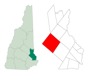
Strafford is a town in Strafford County, New Hampshire, United States. The population was 4,230 at the 2020 census. The two main settlements in town are Center Strafford and Bow Lake Village.

Wolfeboro is a census-designated place (CDP) in the town of Wolfeboro in Carroll County, New Hampshire, United States. It consists of the main village of Wolfeboro within the town, as well as the smaller village of Wolfeboro Falls. The population of the CDP was 3,300 at the 2020 census, out of 6,416 in the entire town of Wolfeboro.

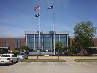
Hooksett is a town in Merrimack County, New Hampshire, United States. The population was 14,871 at the 2020 census, up from 13,451 at the 2010 census. The town is located between Manchester, the state's largest city, and Concord, the state capital. A prominent landmark is Robie's Country Store, a National Historic Landmark and a frequent stop for presidential candidates during the New Hampshire primary.

Farmington is a town in Strafford County, New Hampshire, United States. The population was 6,722 at the 2020 census. Farmington is home to Blue Job State Forest, the Tebbetts Hill Reservation, and Baxter Lake.
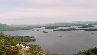
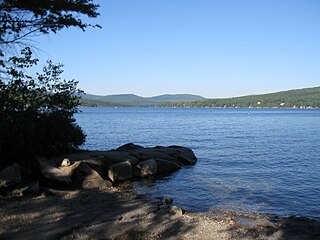
Squam Lake is a lake located in the Lakes Region of central New Hampshire, United States, south of the White Mountains, straddling the borders of Grafton, Carroll, and Belknap counties. The largest town center on the lake is Holderness. The lake is located northwest of much larger Lake Winnipesaukee.

New Hampshire Route 11 is a 108.223-mile-long (174.168 km) east–west state highway in New Hampshire, running completely across the central part of the state. Its western terminus is at the Vermont state line in Charlestown, where it continues west as Vermont Route 11. The eastern terminus is at the Maine state line in Rochester, where it crosses the border with U.S. Route 202 and continues as Maine State Route 11.

The Isinglass River is a 15-mile-long (24 km) river in Strafford County in southeastern New Hampshire, United States. It rises at Bow Lake in the town of Strafford, but is also fed through its tributaries by Ayer's, Nippo, Round and Long ponds in Barrington. The Isinglass flows east to meet the Cochecho River in the southern corner of Rochester. The river is part of the Piscataqua River watershed.
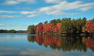
Bow Lake is a 1,149-acre (465 ha) water body located in Strafford and Rockingham counties in eastern New Hampshire, United States, in the towns of Strafford and Northwood. Its outlet is the Isinglass River, flowing east to the Atlantic Ocean via the Cocheco and Piscataqua rivers.
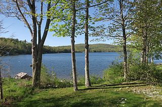
Merrymeeting Lake is a 1,233-acre (4.99 km2) water body located in Strafford County in eastern New Hampshire, United States, in the town of New Durham. Its outlet is the Merrymeeting River, flowing south and then northwest to Lake Winnipesaukee.

Center Strafford is an unincorporated community in the town of Strafford, New Hampshire, United States. It is one of the two principal settlements in the town, along with Bow Lake Village.
Mirror Lake is an unincorporated community in the town of Tuftonboro in Carroll County, New Hampshire. It is located along the shore of Mirror Lake in the Lakes Region of New Hampshire.
Granite Lake is a 233-acre (0.9 km2) lake located in Cheshire County in southwestern New Hampshire, United States, in the towns of Nelson and Stoddard. The village of Munsonville, within the town of Nelson, is located at the outlet. The lake flows into a tributary of Otter Brook, which flows southwest to the Ashuelot River in Keene and thence to the Connecticut River. Granite Lake Dam regulates the lake's water level.

The 2020 New Hampshire Executive Council elections took place on Tuesday, November 3, 2020, to elect all five members of the Executive Council of New Hampshire. The party primaries were held on September 8.


