Durobrivae (Water Newton)

Last updated

Silver cup from the Water Newton Treasure. Cup-text.jpg
Silver cup from the Water Newton Treasure.

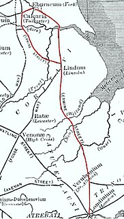
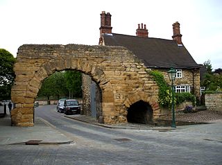
Durobrivae was a Roman fortified garrison town located at Water Newton in the English county of Cambridgeshire, where Ermine Street crossed the River Nene. More generally, it was in the territory of the Corieltauvi in a region of villas and commercial potteries. The name is a Latinisation of Celtic (or more accurately Brythonic) *Durobrīwās, meaning essentially "fort (by the) bridges". [1]

Roman Britain part of the island of Great Britain controlled by the Roman Empire

Roman Britain was the area of the island of Great Britain that was governed by the Roman Empire, from 43 to 410 AD. It comprised almost the whole of England and Wales and, for a short period, southern Scotland.

Water Newton village in the United Kingdom

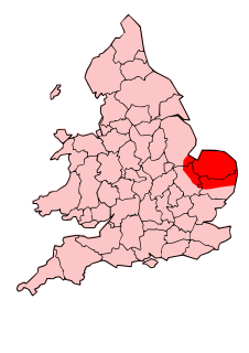
Water Newton is a village and civil parish in Cambridgeshire, England. Water Newton lies approximately 5 miles (8 km) west of Peterborough. Water Newton is situated within Huntingdonshire which is a non-metropolitan district of Cambridgeshire as well as being a historic county of England. As the population of the village was 88 only at the 2011 Census it is included in the civil parish of Chesterton.

England Country in north-west Europe, part of the United Kingdom

England is a country that is part of the United Kingdom. It shares land borders with Wales to the west and Scotland to the north-northwest. The Irish Sea lies west of England and the Celtic Sea lies to the southwest. England is separated from continental Europe by the North Sea to the east and the English Channel to the south. The country covers five-eighths of the island of Great Britain, which lies in the North Atlantic, and includes over 100 smaller islands, such as the Isles of Scilly and the Isle of Wight.

Contents

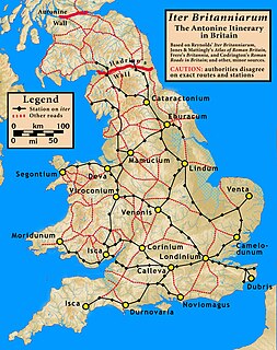
During the Iron Age Britain was divided into distinct tribal areas. The area lay between the Catuvellauni to the south and the Corieltauvi to the north, with the Iceni to the east. The origin of Durobrivae is said to have been as a vicus attached to a "pre-Flavian" fort, established about half a kilometre to the east of modern Water Newton, between the Claudian invasion of 43 AD, and the beginning of the reign of Vespasian in 69 AD. [2] Its first historical mention is in the Antonine Itinerary of the late 2nd century. [3] Archaeology of the Roman period shows that Durobrivae was then the production centre for a fine tableware known as Nene Valley Colour Coated Ware, from the 2nd century to the 4th. [2] In Anglo-Saxon times, local settlement came to centre on Medeshamstede, now known as Peterborough.

The Iron Age is the final epoch of the three-age system, preceded by the Stone Age (Neolithic) and the Bronze Age. It is an archaeological era in the prehistory and protohistory of Europe and the Ancient Near East, and by analogy also used of other parts of the Old World. The three-age system was introduced in the first half of the 19th century for the archaeology of Europe in particular, and by the later 19th century expanded to the archaeology of the Ancient Near East. Its name harks back to the mythological "Ages of Man" of Hesiod. As an archaeological era it was first introduced for Scandinavia by Christian Jürgensen Thomsen in the 1830s. By the 1860s, it was embraced as a useful division of the "earliest history of mankind" in general and began to be applied in Assyriology. The development of the now-conventional periodization in the archaeology of the Ancient Near East was developed in the 1920s to 1930s. As its name suggests, Iron Age technology is characterized by the production of tools and weaponry by ferrous metallurgy (ironworking), more specifically from carbon steel.

Catuvellauni British tribe of the Iron Age and Roman era

The Catuvellauni were a Celtic tribe or state of southeastern Britain before the Roman conquest, attested by inscriptions into the 4th century.

Iceni British tribe of the Iron Age and Roman era

The Iceni or Eceni were a Brittonic tribe of eastern Britain during the Iron Age and early Roman era. Their territory included present-day Norfolk and parts of Suffolk and Cambridgeshire, and bordered the area of the Corieltauvi to the west, and the Catuvellauni and Trinovantes to the south. In the Roman period, their capital was Venta Icenorum at modern-day Caistor St Edmund.

See also

Related Research Articles

Peterborough City and unitary authority in England

Peterborough is a cathedral city in Cambridgeshire, England, with a population of 196,640 in 2015. Historically part of Northamptonshire, it is 75 miles (121 km) north of London, on the River Nene which flows into the North Sea 30 miles (48 km) to the north-east. The railway station is an important stop on the East Coast Main Line between London and Edinburgh. The city is also 70 miles (110 km) east of Birmingham, 38 miles (61 km) east of Leicester, 81 miles (130 km) south of Kingston upon Hull and 65 miles (105 km) west of Norwich.

Watling Street ancient trackway

Watling Street is a route in England that began as an ancient trackway first used by the Britons, mainly between the areas of modern Canterbury and St Albans using a natural ford near Westminster. The Romans later paved the route, which then connected the Kentish ports of Dubris (Dover), Rutupiae (Richborough), Lemanis (Lympne), and Regulbium (Reculver) to their bridge over the Thames at Londinium (London). The route continued northwest past Verulamium (St Albans) on its way to Viroconium (Wroxeter). The Romans considered the continuation on to Blatobulgium (Birrens) beyond Hadrian's Wall to be part of the same route, leading some scholars to call this Watling Street as well, although others restrict it to the southern leg.

Ermine Street road

Ermine Street is the name of a major Roman road in England that ran from London (Londinium) to Lincoln and York (Eboracum). The Old English name was "Earninga Straete" (1012), named after a tribe called the Earningas, who inhabited a district later known as Armingford Hundred, around Arrington, Cambridgeshire and Royston, Hertfordshire. "Armingford", and "Arrington" share the same Old English origin. The original Celtic and Roman names for the route remain unknown. It is also known as the Old North Road from London to where it joins the A1 Great North Road near Godmanchester.

Cornovii (Midlands)

The Cornovii were a Celtic people of Iron Age and Roman Britain, who lived principally in the modern English counties of Cheshire, Shropshire, north Staffordshire, north Herefordshire and eastern parts of the Welsh counties of Flintshire, Powys and Wrexham. Their capital in pre-Roman times was probably a hillfort on the Wrekin. Ptolemy's 2nd-century Geography names two of their towns: Deva Victrix (Chester) and Viroconium Cornoviorum (Wroxeter), which became their capital under Roman rule.

Antonine Itinerary

The Antonine Itinerary is a famous itinerarium, a register of the stations and distances along various roads. Seemingly based on official documents, possibly from a survey carried out under Augustus, it describes the roads of the Roman Empire. Owing to the scarcity of other extant records of this type, it is a valuable historical record.

Isca Dumnoniorum human settlement in United Kingdom

Isca Dumnoniorum, also known simply as Isca, was a town in the Roman province of Britannia at the site of present-day Exeter in the English county of Devon in the United Kingdom. It served as the tribal capital of the Dumnonians under and after the Romans. The city walls of Exeter mark the former perimeter of Isca and excavations in the 1970s and 1980s verified that the town was home to a Roman fortress almost certainly for the Second Augustan Legion. The town seems to have grown up around this fort but seems to have gone into decline prior to the Roman withdrawal from Britain c. 410.

Car Dyke Ditch which runs along the western edge of the Fens in eastern England

The Car Dyke was, and to a large extent still is, a 85 miles (137 km)-long ditch which runs along the western edge of the Fens in eastern England. It is generally accepted as being of Roman age and, for many centuries, to have been taken as marking the western edge of the Fens. There, the consensus begins to break down.

Nene Washes

Nene Washes is a 1,522.1 hectare biological Site of Special Scientific Interest on the bank of the River Nene east of Peterborough in Cambridgeshire. It is also a Ramsar internationally important wetland site, a Special Area of Conservation, a Special Protection Area and a Nature Conservation Review site. An area of 280 hectares is managed by the Royal Society for the Protection of Birds.

Castor, Cambridgeshire village and civil parish in the City of Peterborough, England

Castor is a village and civil parish in the City of Peterborough unitary authority, about 4 miles (6.4 km) west of the city centre. The parish is part of the former Soke of Peterborough, which was considered part of Northamptonshire until 1888 and then Huntingdonshire from 1965-1974, when it became part of Cambridgeshire.

Chesterton, Huntingdonshire a village located in Huntingdonshire, United Kingdom

Chesterton is a village and civil parish in Cambridgeshire, England. Chesterton lies approximately 6 miles (10 km) west of Peterborough near Alwalton. Chesterton is situated within Huntingdonshire which is a non-metropolitan district of Cambridgeshire as well as being a historic county of England.

Lindum Colonia Settlement founded by ancient Romans in eastern England

Lindum Colonia, was the Roman name for the settlement which is now the City of Lincoln in Lincolnshire. It was founded as a Roman Legionary Fortress during the reign of the Emperor Nero (58-68) or possibly later. Evidence from Roman tombstones suggests that Lincoln was first garrisoned by the Ninth Legion, Hispana which probably moved from Lincoln to found the fortress at York around c. 71 AD Lindum was then garrisoned by the Second Legion Aduitrix, which then went on to Chester in 77-78 AD

Blestium geographical object

Blestium was a small fort and iron working centre in the Roman province of Britannia Superior, part of Roman Britain. It has been identified with the site of the later town of Monmouth in south east Wales, located adjoining the confluence of the River Monnow with the River Wye. A plaque on the local bank records its position.

A605 road main road in the English counties of Northamptonshire and Cambridgeshire

The A605 road is a main road in the English counties of Northamptonshire and Cambridgeshire.

Luguvalium was a Roman town in northern Britain in antiquity. It was located within present-day Carlisle, Cumbria, and may have been the capital of the 4th-century province of Valentia.

Ancaster Roman Town small town in the Roman province of Britannia, now in Lincolnshire

Ancaster Roman Town was a small town in the Roman province of Britannia. It is sited on the Roman road known as the Ermine Street and is situated in the county of Lincolnshire. Its name in Latin is unknown, although it has traditionally been identified with Causennis or Causennæ, a name which occurs as a town on the route of Iter V recorded in the Antonine Itinerary. Rivet and Smith questioned this identification in 1979 and suggested that a more likely identification would be either the Roman settlement at Salters ford, near Grantham in Lincolnshire, or at Sapperton in Lincolnshire

Moridunum (Carmarthen)

Moridunum was a Roman fort and town in the Roman province of Britannia. Today it is known as Carmarthen, located in the Welsh county of Carmarthenshire.

Caersws Roman Forts

The Caersws Roman Forts are two Roman military camps at Caersws, Powys in Mid Wales. They were garrisoned during the occupation of Great Britain between the 1st and 5th centuries when this part of Wales was part of the Roman province of Britannia Superior. A surviving section of Roman Road lies to the west of the encampments.

Magnae Dobunnorum Romano-British town and archaeological site

Magnae, sometimes Magnae Dobunnorum to distinguish it from the Magnae of the Carvetii in northern Britain, was a Romano-British town and an important market centre for the British Dobunni tribe, located near modern-day Kenchester in Herefordshire, England. The town was shaped as an irregular hexagon, with a single main street along the line of the main Roman Road running east–west through the area, and an irregular pattern of side streets with tightly packed buildings leading off it.

Nene Valley Colour Coated Ware

Nene Valley Colour Coated Ware is a type of Romano-British ceramic produced in the lower Nene Valley (centered on Durobrivae from the mid-2nd to 4th centuries AD. The full name is usually abbreviated to NVCC.

References

  1. Celtic Names and Roman Places. JSTOR. Retrieved 24 July 2008.
  2. 1 2 Water Newton Huntingdonshire Draft Report. Archived 9 June 2011 at the Wayback Machine . Cambridgeshire County Council. Retrieved 24 July 2008.
  3. Parthey, Gustav and Pinder, Moritz (eds.) Itinerarivm Antonini Avgvsti et Hierosolymitanum: ex libris manu scriptis Iter Britanniarvm (Iter V: Item a Londinio Luguvalio ad vallum mpm clvi sic) Friederich Nicolaus, Berlin, 1848. See also Reynolds, Thomas Iter Britanniarum or that part of the itinerary of Antoninus which relates to Britain with a new comment J. Burges, Cambridge, 1799

Coordinates: 52°33′32″N0°20′54″W / 52.55899°N 0.34821°W / 52.55899; -0.34821

Geographic coordinate system Coordinate system

A geographic coordinate system is a coordinate system that enables every location on Earth to be specified by a set of numbers, letters or symbols. The coordinates are often chosen such that one of the numbers represents a vertical position and two or three of the numbers represent a horizontal position; alternatively, a geographic position may be expressed in a combined three-dimensional Cartesian vector. A common choice of coordinates is latitude, longitude and elevation. To specify a location on a plane requires a map projection.