Cambridgeshire is a county in the East of England, bordering Lincolnshire to the north, Norfolk to the north-east, Suffolk to the east, Essex and Hertfordshire to the south, and Bedfordshire and Northamptonshire to the west. The city of Cambridge is the county town. Following the Local Government Act 1972 restructuring, modern Cambridgeshire was formed in 1974 through the amalgamation of two administrative counties: Cambridgeshire and Isle of Ely, comprising the historic county of Cambridgeshire ; and Huntingdon and Peterborough, comprising the historic county of Huntingdonshire and the Soke of Peterborough, historically part of Northamptonshire. Cambridgeshire contains most of the region known as Silicon Fen.

The Fens, also known as the Fenlands, in eastern England is a naturally marshy region supporting a rich ecology and numerous species. Most of the fens were drained centuries ago, resulting in a flat, dry, low-lying agricultural region supported by a system of drainage channels and man-made rivers and automated pumping stations. There have been unintended consequences to this reclamation, as the land level has continued to sink and the dykes have been built higher to protect it from flooding.
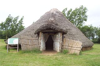
Flag Fen, east of Peterborough, England, is a Bronze Age site which was constructed about 3500 years ago and consists of more than 60,000 timbers arranged in five very long rows, creating a wooden causeway across the wet fenland. Part-way across the structure a small island was formed. Items associated with it have led scholars to conclude that the island was of religious significance. Archaeological work began in 1982 at the site, which is located 800 m east of Fengate. Flag Fen is now part of the Greater Fens Museum Partnership. A visitor centre has been constructed on site and some areas have been reconstructed, including a typical Iron Age roundhouse dwelling.
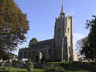
Burwell is a village and civil parish in Cambridgeshire, England, some 10 miles north-east of Cambridge. It lies on the south-east edge of the Fens. Westward drainage is improved by Cambridgeshire lodes (waterways), including Burwell Lode, a growth factor in the village. A population of 6,309 in the 2011 census was put at 6,417 in 2019.
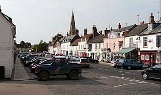
Kimbolton is a town and civil parish in England. Kimbolton is about 9 miles (14 km) west of Huntingdon and 14 miles (23 km) north of Bedford. Kimbolton is administered as part of Cambridgeshire; however it is situated within Huntingdonshire, which is an historic county of England and is now a non-metropolitan district of Cambridgeshire. The parish includes the hamlet of Stonely.

Maxey is a village in the Peterborough unitary authority, in the ceremonial county of Cambridgeshire, England, located between Peterborough and Stamford and southwest of The Deepings. It is home to nearly 700 residents.

Carlton Colville is a civil parish and suburb of Lowestoft in the English county of Suffolk. It is 3 miles (5 km) south-west of the centre of the town, in the East Suffolk district. The area lies along the A146 Lowestoft to Beccles road.

Castor is a village and civil parish in the City of Peterborough unitary authority, about 4 miles (6.4 km) west of the city centre. The parish is part of the former Soke of Peterborough, which was considered part of Northamptonshire until 1888 and then Huntingdon and Peterborough from 1965 to 1974, when it became part of Cambridgeshire.

Bainton is a village and civil parish in the Peterborough unitary authority area of Cambridgeshire, England. Bainton is on the southern edge of the Welland valley and lies 7.4 miles (11.9 km) north-west of Peterborough and 4 miles (6.4 km) east of Stamford. Ashton is a neighbouring hamlet and lies approximately 1 mile (1.6 km) south-east of Bainton within the same civil parish. At the time of the 2001 census, the parish's population was 305 people and by the 2011 census the parish's population was 290 people.

Oakington is a small rural Anglo-Saxon village seven miles (11 km) north-west of Cambridge in Cambridgeshire in England, and belongs to the administrative district of South Cambridgeshire. Since 1985 the village has formed part of the parish of Oakington and Westwick.

Longthorpe Tower is a 14th-century three-storey tower in the village of Longthorpe, famous for its well-preserved set of medieval murals.

Hevingham is a village and civil parish in the Broadland district of the English county of Norfolk. Situated between the A140 road Norwich to Cromer road and the B1149 road Norwich to Holt road. It is 7 miles (11 km) north from the city of Norwich and 4 miles (6.4 km) south from the market town of Aylsham.

Helpston is an English village formerly in the Soke of Peterborough, geographically in Northamptonshire, subsequently (1965–1974) in Huntingdon and Peterborough, then in Cambridgeshire, and administered by the City of Peterborough unitary authority.

Fengate is a predominantly industrial area of the city of Peterborough, in the Peterborough district, in the ceremonial county of Cambridgeshire, England. For electoral purposes it forms part of Peterborough East ward. The industrial estate is known as Eastern Industry. Peterborough Power Station is located here.
Croydon is a small village and civil parish in South Cambridgeshire, England. It is 10 miles (16 km) south-west of Cambridge and immediately west of the A1198 road. The population in 2001 was 221 people, increasing to 235 at the 2011 Census. The site of the deserted medieval village of Clopton is in Croydon parish, which was formerly known as Croydon-cum-Clopton.

Marholm is a village and civil parish in the Peterborough district, in the ceremonial county of Cambridgeshire, England. West of Peterborough and 1 mile from the seat of the Fitzwilliam family at Milton Hall. The parish covers some 1,400 acres, with the village positioned roughly in the centre. For electoral purposes it forms part of Northborough ward in North West Cambridgeshire constituency.

Witchford is a village and civil parish about 2.5 miles (4 km) west of Ely, Cambridgeshire, England. The 2011 Census recorded the parish's population as 2,385.

Little Thetford is a small village in the civil parish of Thetford, 3 miles (5 km) south of Ely in Cambridgeshire, England, about 76 miles (122 km) by road from London. The village is built on a boulder clay island surrounded by flat fenland countryside, typical of settlements in this part of the East of England. During the Mesolithic era, the fenland basin was mostly dry and forested, although subject to salt and fresh water incursions. The marshes and meres of this fenland may therefore have been difficult to occupy, other than seasonally, but there is evidence of human settlement on the island since the late Neolithic Age; a Bronze Age causeway linked the village with the nearby Barway, to the south-east. An investigation, prior to a 1995 development in the village, discovered a farm and large tile-kiln of Romano-British origin; further investigations uncovered an earlier settlement of the Pre-Roman Iron Age. The Roman road Akeman Street passed through the north-west corner of the parish, and the lost 7th century Anglo-Saxon village of Cratendune may be nearby.

Woodcroft Castle is a moated medieval castle in the parish of Etton, Cambridgeshire, England.

There are over 670 scheduled monuments in the ceremonial county of Somerset in South West England. The county consists of a non-metropolitan county, administered by Somerset County Council, which is divided into five districts, and two unitary authorities. The districts of Somerset are West Somerset, South Somerset, Taunton Deane, Mendip and Sedgemoor. The two administratively independent unitary authorities, which were established on 1 April 1996 following the breakup of the county of Avon, are North Somerset and Bath and North East Somerset. These unitary authorities include areas that were once part of Somerset before the creation of Avon in 1974.

