Cambridgeshire is a county in the East of England, bordering Lincolnshire to the north, Norfolk to the north-east, Suffolk to the east, Essex and Hertfordshire to the south, and Bedfordshire and Northamptonshire to the west. The city of Cambridge is the county town. Following the Local Government Act 1972 restructuring, modern Cambridgeshire was formed in 1974 through the amalgamation of two administrative counties: Cambridgeshire and Isle of Ely, comprising the historic county of Cambridgeshire ; and Huntingdon and Peterborough, comprising the historic county of Huntingdonshire and the Soke of Peterborough, historically part of Northamptonshire. Cambridgeshire contains most of the region known as Silicon Fen.

Peterborough is a cathedral city in the City of Peterborough district in Cambridgeshire, England, with a population of 215,700 in 2021. Originally part of Northamptonshire, it became part of Cambridgeshire from 1974. The city is 76 mi (122 km) north of London, on the River Nene which flows into the North Sea 30 mi (48 km) to the north-east. The railway station is an important stop on the East Coast Main Line between London and Edinburgh.

The Ring of Brodgar is a Neolithic henge and stone circle about 6 miles north-east of Stromness on Mainland, the largest island in Orkney, Scotland. It is part of the UNESCO World Heritage Site known as the Heart of Neolithic Orkney.
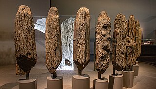
Seahenge, also known as Holme I, was a prehistoric monument located in the village of Holme-next-the-Sea, near Old Hunstanton in the English county of Norfolk. A timber circle with an upturned tree root in the centre, Seahenge, along with the nearby timber circle Holme II, was built in the spring-summer of 2049 BCE, during the early Bronze Age in Britain. Contemporary theory is that they were used for ritual purposes; in particular Holme II has been interpreted as a mortuary monument that may originally have formed the boundary of a burial mound.
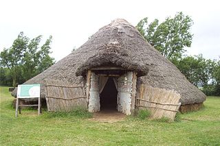
Flag Fen, east of Peterborough, England, is a Bronze Age site which was constructed about 3500 years ago and consists of more than 60,000 timbers arranged in five very long rows, creating a wooden causeway across the wet fenland. Part-way across the structure a small island was formed. Items associated with it have led scholars to conclude that the island was of religious significance. Archaeological work began in 1982 at the site, which is located 800 m east of Fengate. Flag Fen is now part of the Greater Fens Museum Partnership. A visitor centre has been constructed on site and some areas have been reconstructed, including a typical Iron Age roundhouse dwelling.

There are three related types of Neolithic earthwork that are all sometimes loosely called henges. The essential characteristic of all three is that they feature a ring-shaped bank and ditch, with the ditch inside the bank. Because the internal ditches would have served defensive purposes poorly, henges are not considered to have been defensive constructions. The three henge types are as follows, with the figure in brackets being the approximate diameter of the central flat area:
- Henge (> 20 m). The word henge refers to a particular type of earthwork of the Neolithic period, typically consisting of a roughly circular or oval-shaped bank with an internal ditch surrounding a central flat area of more than 20 m (66 ft) in diameter. There is typically little if any evidence of occupation in a henge, although they may contain ritual structures such as stone circles, timber circles and coves. Henge monument is sometimes used as a synonym for henge. Henges sometimes, but by no means always, featured stone or timber circles, and circle henge is sometimes used to describe these structures. The three largest stone circles in Britain are each within a henge. Examples of henges without significant internal monuments are the three henges of Thornborough Henges. Although having given its name to the word henge, Stonehenge is atypical in that the ditch is outside the main earthwork bank.
- Hengiform monument (5 – 20 m). Like an ordinary henge, except the central flat area is between 5 and 20 m (16–66 ft) in diameter, they comprise a modest earthwork with a fairly wide outer bank. The terms Mini henge or Dorchester henge are sometimes used as synonyms for hengiform monument. An example is the Neolithic site at Wormy Hillock Henge.
- Henge enclosure (> 300 m). A Neolithic ring earthwork with the ditch inside the bank, with the central flat area having abundant evidence of occupation and usually being more than 300 m (980 ft) in diameter. Some true henges are as large as this, but lack evidence of domestic occupation. Super henge is sometimes used as a synonym for a henge enclosure. However, sometimes Super henge is used to indicate size alone rather than use, e.g. "Marden henge ... is the least understood of the four British 'superhenges' ".

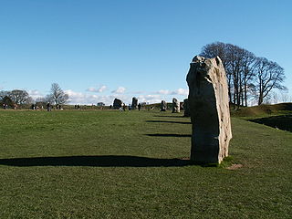
Avebury is a Neolithic henge monument containing three stone circles, around the village of Avebury in Wiltshire, in southwest England. One of the best known prehistoric sites in Britain, it contains the largest megalithic stone circle in the world. It is both a tourist attraction and a place of religious importance to contemporary pagans.

Windmill Hill is a Neolithic causewayed enclosure in the English county of Wiltshire, part of the Avebury World Heritage Site, about 1 mile (2 km) northwest of Avebury. Enclosing an area of 21 acres (8.5 ha), it is the largest known causewayed enclosure in Britain. The site was first occupied around 3800 BC, although the only evidence is a series of pits apparently dug by an agrarian society using Hembury pottery.

Durrington Walls is the site of a large Neolithic settlement and later henge enclosure located in the Stonehenge World Heritage Site in England. It lies 2 miles (3.2 km) north-east of Stonehenge in the parish of Durrington, just north of Amesbury in Wiltshire. The henge is the second-largest Late Neolithic palisaded enclosure known in the United Kingdom, after Hindwell in Wales.
The Thornborough Henges are an unusual ancient monument complex that includes the three aligned henges that give the site its name. The complex is located near the village of Thornborough, close to the town of Masham in North Yorkshire, England. The complex includes many large ancient structures including a cursus, henges, burial grounds and settlements.

The Sanctuary was a stone and timber circle near the village of Avebury in the south-western English county of Wiltshire. Excavation has revealed the location of the 58 stone sockets and 62 post-holes. The ring was part of a tradition of stone circle construction that spread throughout much of Britain, Ireland, and Brittany during the Late Neolithic and Early Bronze Age, over a period between 3300 and 900 BCE. The purpose of such monuments is unknown, although archaeologists speculate that the stones represented supernatural entities for the circle's builders.

King Arthur's Round Table is a Neolithic henge in the village of Eamont Bridge in the English county of Cumbria, around 2 kilometres (1 mi) south east of Penrith. It is 400 metres from Mayburgh Henge. The site is free to visitors and is under the control of English Heritage.

In archaeology, an enclosure is one of the most common types of archaeological site – It is any area of land separated from surrounding land by earthworks, walls or fencing. Such a simple feature is found all over the world and during almost all archaeological periods. They may be few metres across or be large enough to encompass whole cities.
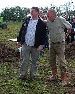
Francis Manning Marlborough Pryor is an English archaeologist specialising in the study of the Bronze and Iron Ages in Britain. He is best known for his discovery and excavation of Flag Fen, a Bronze Age archaeological site near Peterborough, as well as for his frequent appearances on the Channel 4 television series Time Team.

Bainton is a village and civil parish in the Peterborough unitary authority area of Cambridgeshire, England. Bainton is on the southern edge of the Welland valley and lies 7.4 miles (11.9 km) north-west of Peterborough and 4 miles (6.4 km) east of Stamford. Ashton is a neighbouring hamlet and lies approximately 1 mile (1.6 km) south-east of Bainton within the same civil parish. At the time of the 2001 census, the parish's population was 305 people and by the 2011 census the parish's population was 290 people.

Mayburgh Henge is a large prehistoric monument in the county of Cumbria in northern England. The henge is in the care of English Heritage and is a Scheduled Ancient Monument. It is 400 metres from King Arthur's Round Table Henge.

Fengate is a predominantly industrial area of the city of Peterborough, in the Peterborough district, in the ceremonial county of Cambridgeshire, England. For electoral purposes it forms part of Peterborough East ward. The industrial estate is known as Eastern Industry. Peterborough Power Station is located here.

Etton is a village and civil parish in the unitary authority area of the city of Peterborough, Cambridgeshire, in England. For electoral purposes it forms part of Northborough ward in North West Cambridgeshire constituency. The parish had a population of 158 persons and 58 households in 2001.
Chacombe is a village and civil parish in West Northamptonshire, England, about 3 miles (5 km) north-east of Banbury. It is bounded to the west by the River Cherwell, to the north by a tributary and to the south-east by the Banbury–Syresham road. The 2011 Census gave a parish population of 659 and a 2019 estimate 693.
Ritual landscapes or ceremonial landscapes are large archaeological areas that were seemingly dedicated to ceremonial purposes in the Neolithic and Bronze Ages. Most are dated to around 3500–1800 BC, though a mustatil in Arabia has been dated to between 5300 and 5000 BC. The term emerged in the early 1980s in British archaeology and was contrasted with more conventional studies of monument sites concerned with dating, classification, and political divisions. Ritual landscapes are often associated with origin myths, ancestors, homes of spiritual essences, or locales where mythical or historical events occurred while the landscape features include social memory and the preservation of the myths, histories, trusts, and the belongings of a people. Aside from a place of origin and mythology, ritual landscapes were also considered places of protection and renewal.