Related Research Articles
Eas a' Chual Aluinn in the parish of Assynt, Sutherland, Highland, Scotland, is the tallest waterfall in the United Kingdom with a sheer drop of 200 m (660 ft). When in full flow it is over three times taller than Niagara Falls.

Glen Tilt is a glen in the extreme north of Perthshire, Scotland. Beginning at the confines of Aberdeenshire, it follows a South-westerly direction excepting for the last 4 miles, when it runs due south to Blair Atholl. It is watered throughout by the Tilt, which enters the Garry after a course of 14 miles, and receives on its right the Tarf, which forms some beautiful falls just above the confluence, and on the left the Fender, which has some fine falls also. The attempt of George Murray, 6th Duke of Atholl to close the glen to the public was successfully contested by the Scottish Rights of Way Society in 1847. The massive mountain of Beinn a' Ghlò and its three Munros Càrn nan Gabhar, Bràigh Coire Chruinn-bhalgain and Càrn Liath (975) dominate the glen's eastern lower half.
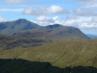
Beinn Chùirn is a hill five kilometres west-south-west of Tyndrum, Scotland, standing on the border of Stirlingshire and Perthshire at the northern extremity of the Loch Lomond and The Trossachs National Park.

Stob an Eas is a 2401 ft (732m) Graham in the Arrochar Alps, Argyll and Bute, Scotland.

Glen Cannich is a long glen in the Northwest Highlands of Scotland and through which runs the River Cannich. Emerging from the reservoir of Loch Mullardoch, the river flows east to merge with the River Affric at the village of Cannich, their combined waters forming the River Glass.
Achness Falls, also known as the Achness Waterfall or Cassley Falls, is a waterfall located on the River Cassley in Sutherland, Scotland, near Rosehall and Invercassley. Its name is derived from the Scottish Gaelic Ach-an-eas, the "field of the waterfall".

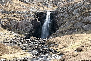
Dog Falls is a series of waterfalls on the River Affric, in Glen Affric in the Highlands of Scotland. The falls are within the Glen Affric National Nature Reserve, managed by Forestry and Land Scotland. There are several way-marked paths to the falls.
Eas a' Chrannaig also known as the Glenashdale Falls is a waterfall on the island of Arran, Scotland. There are a series of falls on the Glenashdale Burn, which flows from moorland near the summit of Tighvein eastwards towards Whiting Bay, from which there is a tourist trail leading some 4 kilometres (2.5 mi) up Glenashdale.
Eas Creag an Luchda is a waterfall of Scotland.

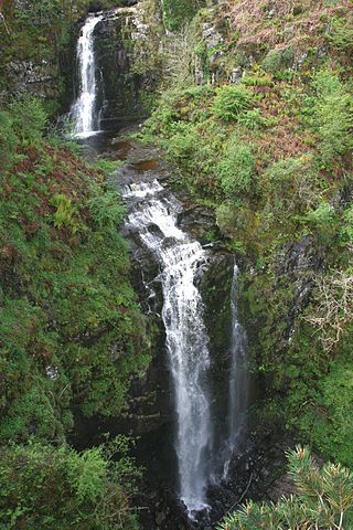
Plodda Falls is a waterfall, situated 5 km south-west of the village of Tomich, near Glen Affric, in the Highlands of Scotland. The falls are 46 m high, and are on the Allt na Bodachan, near where it flows into the Abhainn Deabhag, which in turn joins with the River Affric to form the River Glass.
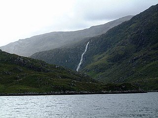
Eas Maol Mhairi is a waterfall of Scotland. Just east of this waterfall is the River Cannich.
Eas Mor (lower) is a waterfall on the Abhainn Ghil on the island of Islay, in Scotland. It lies on the west coast of The Oa peninsula north of Lower Killeyan.
Eas Mor is a waterfall is a waterfall on the Abhainn Ghil on the island of Islay in Scotland. It lies on The Oa peninsula south of Giol and west of Lenavore.

Eas Mòr is a waterfall in Glen Brittle on the island of Skye in Scotland. It lies on the Allt Coire na Bannachdich in a small gorge east of Glenbrittle House.
Easan Labhar is a series of waterfalls on the island of Mull, Scotland. It lies on the Allt an Easain Labhair near Gruline west of Salen. There are also unnamed waterfalls on the Allt na Linne burn just to the east.

Kinnesswood, possibly from the Scottish Gaelic: Ceann eas ciad is a village in Perth and Kinross, Scotland, and is in the historic county of Kinross-shire. It lies to the east of Loch Leven, on the A911 road, below Bishop Hill in the Lomond Hills. It is approximately 4 miles west of Glenrothes and 4 miles east of Kinross.
Eas Mòr is the name of a number of waterfalls in Scotland:
Eas Dubh is the name of a number of waterfalls in Scotland:

Carsaig Arches are natural arch cliff formations on the Ross of Mull in the south of the Isle of Mull, on the west coast of Scotland. They are situated below Malcolm's Point, at the base of the Rudha Fhaoilean cliffs. To the east are Carsaig Bay, and Eas na Dabhaich.

Puck's Glen is a river-formed ravine on the Cowal peninsula in Argyll and Bute, Scotland, with a popular scenic walking trail beside the Eas Mòr stream. In 2020 the glen and adjoining trails were closed temporarily due to COVID-19 restrictions, issues of stability of the gorge, and felling of trees infected by larch disease.
References
- ↑ Ordnance Survey 1:25,000 scale Explorer map series, sheets 309-470
- ↑ "Norske ordbøker" Retrieved 18 September 2010.
Coordinates: 56°34′06″N6°11′48″W / 56.56828°N 6.19664°W
| Main settlements |  | |
|---|---|---|
| Smaller settlements | ||
| Geographical features | ||
| History and architecture | ||
| Local culture and economy | ||
| Surrounding islands | ||
| | This Scottish location article is a stub. You can help Wikipedia by expanding it. |