
Dartmoor is an upland area in southern Devon, South West England. The moorland and surrounding land has been protected by National Park status since 1951. Dartmoor National Park covers 954 km2 (368 sq mi).

Postbridge is a hamlet in the heart of Dartmoor in the English county of Devon. It lies on the B3212, roughly midway between Princetown and Moretonhampstead.

The River Dart is a river in Devon, England, that rises high on Dartmoor and flows for 75 kilometres (47 mi) to the sea at Dartmouth.

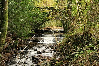
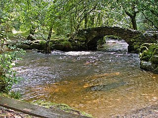
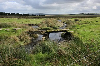
A clapper bridge is an ancient form of bridge found on the moors of the English West Country and in other upland areas of the United Kingdom including Snowdonia and Anglesey, Cumbria, Derbyshire, Yorkshire, Lancashire, and in northern Wester Ross and north-west Sutherland in Scotland. It is formed by large flat slabs of stone, often granite or schist. These can be supported on stone piers across rivers, or rest on the banks of streams.

River Walkham is a river whose source is on Dartmoor, Devon, England.
The Ashburn is a river in the Dartmoor moors in Devon in south-west England, flowing through the Ashburton valley to the River Dart.
The River Bovey rises on the eastern side of Dartmoor in Devon, England, and is the largest tributary to the River Teign. The river has two main source streams, both rising within a mile of each other, either side of the B3212 road between Moretonhampstead and Postbridge, before joining at Jurston.

The East Webburn is a stream in the Dartmoor moors in Devon in south-west England. It rises on the western side of the moors flowing off the west side of Hameldown ridge. Its source is less than 1 kilometre south west of Grimspound Bronze Age settlement. It flows south past Widecombe-in-the-Moor and joins the West Webburn River at Lizwell Meet in Oakmoor Wood. These combined streams then join the River Dart close to the village of Holne.

The River Swincombe is a right-bank tributary of the West Dart River that flows through Dartmoor national park in Devon, south-west England. It rises south-east of Princetown, and flows 2 km south-east to Foxtor Mires, where it turns north-east to meet the West Dart near Hexworthy. The first 2 km are known as the Strane River. Some maps show that the source starts north of Nakers Hill and heads north west to the east of Foxtor Mires where it meets the Strane River which is its own river.

The West Webburn is a stream on Dartmoor in Devon in south-west England. It rises on the eastern side of the moors flowing off the east side of Hameldown Ridge. Its source is extremely close to the Grimspound Bronze Age settlement, and it was probably the main source of water for the settlement. It flows south, going past Widecombe-in-the-Moor, and joins the East Webburn River at Lizwell Meet in Oakmoor Wood. These combined streams then join the River Dart at Buckland Bridge close to the village of Holne.
The West Dart River is one of the two main tributaries of the River Dart in Devon, England.

The Glenelg River, a perennial river of the Glenelg Hopkins catchment, is located in the Australian states of Victoria and South Australia.

Bellever is a hamlet in Dartmoor, Devon, England. It is located on the river East Dart about 2 kilometres (1 mi) south of Postbridge.
Dartmoor Forest is a civil parish in Devon, England. It was formed in 1987 by the splitting of the former parish of Lydford. It covers about 56,000 acres (230 km2) entirely within Dartmoor National Park, and is the largest parish in Devon. Despite its size its population in 2001 was only 1,619. Due to its large size it is surrounded by many other parishes: these are, clockwise from the north, Belstone, South Tawton, Throwleigh, Gidleigh, Chagford, North Bovey, Manaton, Widecombe in the Moor, Holne, West Buckfastleigh, Dean Prior, South Brent, Ugborough, Harford, Cornwood, Shaugh Prior, Sheepstor, Walkhampton, Whitchurch, Peter Tavy, Lydford, land common to the parishes of Bridestowe and Sourton, and Okehampton Hamlets.

Dartmouth Harbour is a natural port located in Dartmouth, Devon, England. It is situated at the mouth of the River Dart on the English Channel. Bayard's Cove Fort is a small fort, which was built to defend the harbour's entrance. The crafts which dock at the port are mainly local fishing vessels, naval ships and luxury yachts; warships routinely visit the harbour. The River Dart is navigable from Dartmouth to the old weir location at Totnes.
The Walla Brook is the name of four different streams on Dartmoor, England:

The Cherry Brook is a tributary of the West Dart River on Dartmoor, Devon, England.

The River Mardle is a tributary of the River Dart in Devon, England.
The Blackbrook River, also known as the Blackabrook River, is a tributary of the West Dart River on Dartmoor in Devon, England.
Cut Hill is a hill in North Dartmoor in the southwest English county of Devon. At 603 metres high, it is the joint third highest peak in Devon and Dartmoor, together with Hangingstone Hill, which lies around 4 kilometres to the northeast.


