
Dartmoor is an upland area in southern Devon, South West England. The moorland and surrounding land has been protected by National Park status since 1951. Dartmoor National Park covers 954 km2 (368 sq mi).

The Devonport Leat is a leat in Devon constructed in the 1790s to carry fresh drinking water from the high ground of Dartmoor to the expanding dockyards at Plymouth Dock.

The River Dart is a river in Devon, England, that rises high on Dartmoor and flows for 75 kilometres (47 mi) to the sea at Dartmouth.

The River Teign is a river in the county of Devon, England. It is 31 mi (50 km) long and rises on Dartmoor, becomes an estuary just below Newton Abbot and reaches the English Channel at Teignmouth.

The Walkham is a river whose source is on Dartmoor, Devon, England. It rises in the wide gap between Roos Tor and Great Mis Tor and flows almost due south for approximately 3 miles (4.8 km) leaving the tors and thus National Park behind then south-west for 1 mile (1.6 km) past Woodtown. The river then reaches a village, Horrabridge, with a small compact network of streets mainly on the south or left bank. It receives most of its tributaries which are unnamed headwaters along its south-flowing inception, draining the near side of two series of six tors (peaks) to the west ending in Pew Tor at 320 metres and likewise to the east ending in Leeden Tor at 389 metres. In absolute distance, 2 miles (3.2 km) west of the village and the same south of the small well-preserved town of Tavistock by a footbridge on the West Devon Way the Walkham joins the Tavy which discharges into the Tamar Estuary north of the Plymouth conurbation after a fast descent around wide hillsides, a few miles south.

Dartmeet is a popular tourist spot in the centre of Dartmoor, Devon, England at grid reference SX672731.
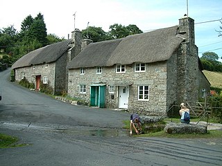
Ponsworthy is a hamlet on the eastern side of Dartmoor, Devon, England. It lies in the steep valley of the West Webburn River about 3.5 km (2.2 mi) southwest of the village of Widecombe-in-the-Moor.

The tin mining industry on Dartmoor, Devon, England, is thought to have originated in pre-Roman times, and continued right through to the 20th century, when the last commercially worked mine closed in November 1930. From the 12th century onwards tin mining was regulated by a stannary parliament which had its own laws.

The Erme is a river in south Devon, England. From its source on Dartmoor it flows in a generally southerly direction past some of the best-preserved archaeological remains on the moor. It leaves the moor at the town of Ivybridge and continues southward, passing the settlements of Ermington, Modbury and Holbeton. Near Holbeton it becomes a ria and empties into the English Channel in Bigbury Bay, between the rivers Yealm and Avon.

Belstone is a small village and civil parish in the West Devon District of Devon, England.
The River Okement is a tributary of the River Torridge in Devon, England. It rises at two places in Dartmoor, as the West Okement and the East Okement. These meet with other minor streams and join together at Okehampton. The river flows generally north, past the villages of Jacobstowe and Monkokehampton, and has its confluence with the River Torridge near Meeth.

South Dartmoor Community College (SDCC) is a co-educational academy school located in Ashburton, Devon, England. The number of students on roll is 1,650. The school has a sixth form centre and has become a Specialist Sports College with Training School Status that is strongly linked with Ashmoor Hockey Club.
The Ashburn is a river in the Dartmoor moors in Devon in south-west England, flowing through the Ashburton valley to the River Dart.
The River Bovey rises on the eastern side of Dartmoor in Devon, England, and is the largest tributary to the River Teign. The river has two main source streams, both rising within a mile of each other, either side of the B3212 road between Moretonhampstead and Postbridge, before joining at Jurston.

The East Okement is a river in the Dartmoor moors in Devon in south-west England. It joins the West Okement at Okehampton to form the Okement.

The River Lemon is a 9.9 miles river in the county of Devon in southwest England. It is a tributary of the River Teign, starting on Dartmoor by Haytor, and ending in Newton Abbot. It rises on the south-east side of Dartmoor near Haytor, joins with the River Sig and the Langworthy Brook at Sigford, then passes the village of Bickington. Lower down, it is joined by the Kestor Brook and it then flows through the woods in Bradley Valley, past the manor house of Bradley, and through the town of Newton Abbot where it flows through a 440-yard-long (400 m) tunnel below the town centre. Just below the town, the river joins the River Teign at 50.517°N 3.607°W, near the head of its estuary.

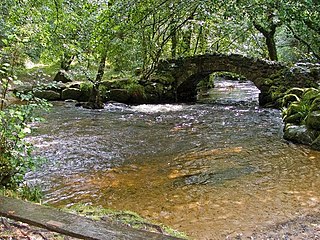
The West Webburn is a stream on Dartmoor in Devon in south-west England. It rises on the eastern side of the moors flowing off the east side of Hameldown Ridge. Its source is extremely close to the Grimspound Bronze Age settlement, and it was probably the main source of water for the settlement. It flows south, going past Widecombe-in-the-Moor, and joins the East Webburn River at Lizwell Meet in Oakmoor Wood. These combined streams then join the River Dart at Buckland Bridge close to the village of Holne.

Dewerstone is the site of an Iron Age Hill fort on a rocky promontory overlooking the River Plym on the South West edge of Dartmoor to the North of Plympton in Devon. The fort consists of ramparts to the Northern side of the promontory at approx 210 Metres above Sea Level.

The River Ottery is a small river in northeast Cornwall, England, United Kingdom. The river is about twenty miles (32 km) long from its source southeast of Otterham to its confluence with the River Tamar at Nether Bridge, two miles (3.2 km) northeast of Launceston.

The River Sig is a 2.4 mile long river on Dartmoor in the county of Devon, England. It is a tributary to the River Lemon which it meets at Sigford.
