The M5 is a motorway in England linking the Midlands with the South West. It runs from junction 8 of the M6 at West Bromwich near Birmingham to Exeter in Devon. Heading south-west, the M5 runs east of West Bromwich and west of Birmingham through Sandwell Valley. It continues past Bromsgrove, Droitwich Spa, Worcester, Tewkesbury, Cheltenham, Gloucester, Bristol, Clevedon, Weston-super-Mare, Bridgwater, Taunton, terminating at junction 31 for Exeter. Congestion on the section south of the M4 is common during the summer holidays, on Friday afternoons and bank holidays.

Bradninch is a small town, civil parish and manor in Devon, England, lying about 3 mi (5 km) south of Cullompton. Much of the surrounding farmland belongs to the Duchy of Cornwall. There is an electoral ward with the same name, which since May 2023 comprises the entire parish. The population was 2,165 in 2021.

Mid Devon is a local government district in Devon, England. The council is based in the district's largest town of Tiverton. The district also contains the towns of Bampton, Bradninch, Crediton and Cullompton, along with numerous villages and surrounding rural areas. Part of the district lies within the Blackdown Hills, an Area of Outstanding Natural Beauty.

Cullompton is a town and civil parish in the district of Mid Devon and the county of Devon, England. It is 13 miles (21 km) north-east of Exeter and lies on the River Culm. In 2011, the parish as a whole had a population of 8,499, while the built-up area of the town had a population of 7,439.

Hemyock is a village and civil parish in Devon, England. It is about 8 miles north-west of Honiton and 5 miles (8 km) south of the Somerset town of Wellington. The 2011 Census recorded the parish's population as 1,519. Hemyock is part of the electoral ward of Upper Culm. The population of this ward at the above census was 4,039. The River Culm flows through Hemyock. Hemyock was the former home of the St Ivel dairy processing plant, formerly where the butter-spreads 'St Ivel Gold' and 'Utterly-Butterly' were produced before being moved to a factory in the north of England.

The Blackdown Hills National Landscape is a National Landscape along the Somerset-Devon border in south-western England, which were designated in 1991 as an Area of Outstanding Natural Beauty (AONB). In November 2023, it has become 'Blackdown Hills National Landscape' The area encompasses a set of hills of the same name.

Willand is a village and civil parish in Mid Devon, England. It is about 19 km (12 mi) north of Exeter and 2.4 km (1.5 mi) north of Cullompton. In 1991 the population was 3750 although recently this has grown considerably. The National Grid reference for the centre of the area is ST037110. Willand is a major part of Lower Culm electoral ward. The ward population at the 2011 Census was 5,808. The parish is surrounded, clockwise from the north, by the parishes of Halberton, Uffculme and Cullompton.

Uffculme is a village and civil parish located in the Mid Devon district, of Devon, England. Situated in the Blackdown Hills on the B3440, close to the M5 motorway and the Bristol–Exeter railway line, near Cullompton, Uffculme is on the upper reaches of the River Culm. The population of the parish, according to a 2020 estimate, is 3,090. It is surrounded, clockwise from the north, by the parishes of Culmstock, Hemyock, Sheldon, Kentisbeare, Cullompton, Willand, Halberton and Burlescombe.

Cullompton services is a motorway service station on the M5 motorway near Exeter. It is owned by Extra MSA. It has a McDonald's restaurant which is franchised and offers table service, a small WHSmith and a Costa Coffee which is owned by Moto Hospitality. There is also a Shell petrol station nearby.

The A379 is a road in the English county of Devon. It links points on the edges of that county's two principal cities, Exeter and Plymouth, by an indirect and largely coastal route. The A38 provides a faster and more direct inland route between Exeter and Plymouth, whilst the A380 provides a similarly faster route between Exeter and the Torbay area. However the A379 serves many small coastal communities and ports along the coast. The indented nature of the South Devon coast means that the road is usually out of sight of the sea, but the many rivers and estuaries are crossed by bridges and, in one case, a cable ferry.
There are 22 disused railway stations on the Bristol to Exeter line between Bristol Temple Meads and Exeter St Davids. The line was completed in 1844 at which time the temporary terminus at Beambridge was closed. The most recent closure was Tiverton Junction which was replaced by a new station} on a different site in 1986. 12 of the disused stations have structures that can still be seen from passing trains.
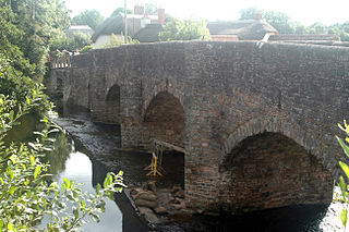
Culmstock is a village and civil parish in Mid Devon, England, centred 10 miles from Tiverton and 6 NE of Cullompton. It is laid out on both sides of the River Culm; the village is joined by a single old narrow stone bridge across the river. The population of the parish at the 2011 Census was 554. The northern boundary of the parish forms part of the Devon – Somerset border and clockwise from there it is surrounded by the Devon parishes of Hemyock, Uffculme, Burlescombe and Holcombe Rogus.
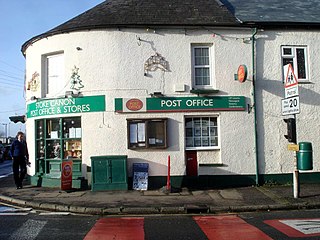
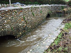
Stoke Canon is a small village and civil parish near the confluence of the rivers Exe and Culm on the main A396 between Exeter and Tiverton in the English county of Devon, and the district of East Devon. At the 2001 census it had a population of 660. The population was unchanged in 2011 but the village forms the major part of the Exe Valley electoral ward. The population of this ward was 2,041 at the 2011 Census.

The Culm Valley Light Railway was a standard gauge branch railway that operated in the English county of Devon. It ran for just under 7+1⁄2 miles (12.1 km) from Tiverton Junction station on the Bristol to Exeter line, through the Culm valley to Hemyock.

The Bristol to Exeter line is a major branch of the Great Western Main Line in the West of England and runs from Bristol, to Exeter, from where it continues as the Exeter to Plymouth line. It was one of the principal routes of the pre-1948 Great Western Railway which were subsequently taken over by the Western Region of British Railways and are now part of the Network Rail system.
South Devon is the southern part of Devon, England. Because Devon has its major population centres on its two coasts, the county is divided informally into North Devon and South Devon. In a narrower sense "South Devon" is used to refer to the part of Devon south of Exeter and Dartmoor, including Plymouth, Torbay and the districts of South Hams, West Devon and Teignbridge.

Perlycross: a tale of the western hills is a three-volume novel by R. D. Blackmore published in 1894. The story is set in eastern Devon around 1830.
Moor Hays is a historic estate in the parish of Cullompton in Devon, England. It is stated incorrectly to be in the nearby parish of Burlescombe in Tristram Risdon's Survey of Devon. The estate is not to be confused with Moor Hayes in the parish of Washfield, about 3 miles north-west of Tiverton, another ancient farmstead, which since 2005 has been the site of a large housing estate named "Moorhayes".