Wayne County is the westernmost county in the U.S. state of West Virginia. As of the 2010 census, the population was 42,481. Its county seat is Wayne. The county was founded in 1842 and named for General "Mad" Anthony Wayne.

Harts is a census-designated place (CDP) at the mouth of Big Harts Creek in Lincoln County, West Virginia, United States, along the Guyandotte River. As of the 2010 census, its population was 656. Harts is a part of the Huntington-Ashland, WV-KY-OH, Metropolitan Statistical Area (MSA). As of the 2010 census, the MSA had a population of 287,702. New definitions from February 28, 2013 placed the population at 363,000.

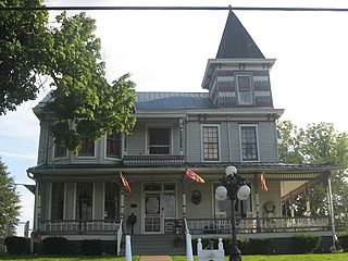
Wayne is a town in Wayne County, West Virginia, United States. The population was 1,413 at the 2010 census. It is the county seat of Wayne County. Wayne is a part of the Huntington-Ashland, WV-KY-OH, Metropolitan Statistical Area. As of 2015, the MSA had a population of 361,580.

Confidence is an unincorporated community in Putnam County West Virginia located on WV 34. The community is served by Confidence Elementary School. Confidence is a part of the Huntington-Ashland Metropolitan Statistical Area (MSA). As of the 2010 census, the MSA had a population of 287,702. New definitions from February 28, 2013 placed the population at 363,000.
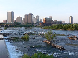
The Greater Richmond Region, the Richmond metropolitan area or Central Virginia, is a region and metropolitan area in the U.S. state of Virginia, centered on Richmond. The U.S. Office of Management and Budget (OMB) defines the area as the Richmond, VA Metropolitan Statistical Area, a Metropolitan Statistical Area (MSA) used by the U.S. Census Bureau and other entities. The OMB defines the area as comprising 17 county-level jurisdictions, including the independent cities of Richmond, Petersburg, Hopewell, and Colonial Heights. As of 2016, it had a population of 1,263,617, making it the 45th largest MSA in the country.
Lavalette is a census-designated place (CDP) in Wayne County, West Virginia, in the United States. As of the 2010 census, its population was 1,073. Lavalette is located at the intersection of West Virginia Route 152 and West Virginia Route 75, eight miles south of Huntington. The town is near Beech Fork Lake, a popular location for boating and fishing, and Twelvepole Creek. Lavalette was named after Lavalette Miller, the daughter of a Norfolk & Western Railway official.
Brabant is an unincorporated community in Wayne County, West Virginia, United States. Brabant is a part of the Huntington-Ashland Metropolitan Statistical Area (MSA). As of the 2010 census, the MSA had a population of 287,702. New definitions from February 28, 2013 placed the population at 363,000.
Armilda is an unincorporated community located approximately five miles south of the town of Wayne in Wayne County, West Virginia, United States. Armilda was named for the wife of a settler. The one room Armilda Schoolhouse was located there. A Norfolk and Western Railway flag station on the rail line that ran to East Lynn was also once located there. When the East Lynn Lake was under construction in the 1960s, the graves in the immediate area were moved to a large cemetery constructed on the hill overlooking Armilda. The cemetery is named Community Memorial Gardens and is also commonly known as the "government cemetery." Armilda is a part of the Huntington-Ashland Metropolitan Statistical Area (MSA). As of the 2010 census, the MSA had a population of 287,702. New definitions from February 28, 2013 placed the population at 363,000.

Meads is an unincorporated community in Boyd County, Kentucky, United States. It is located along the U.S. Highway 60 corridor south of Ashland.
Princess is a small unincorporated community in Boyd County, Kentucky, United States. Princess is located along Kentucky Route 5, near the intersection of U.S. Route 60 and Kentucky Route 5.
Crum is a census-designated place (CDP) in southern Wayne County, West Virginia, United States. As of the 2010 census, its population was 182. It is the home to Crum Pre K-8 school opened in 2017. It is a part of the Huntington-Ashland Metropolitan Statistical Area (MSA).

The Charleston Metropolitan Statistical Area, as defined by the United States Census Bureau, is an area consisting of three counties in West Virginia, anchored by the city of Charleston. It is the largest metropolitan area entirely within the state of West Virginia. While the Huntington Metro Area is more populous, it spans three states, and the core county of the Charleston area, Kanawha County, is more populous than the West Virginia portion of the Huntington area.

The Huntington–Ashland metropolitan area is a metropolitan area in the Appalachian Plateau region of the United States. Referred to locally as the “Tri-State area”, the region spans seven counties in the three states of West Virginia, Kentucky, and Ohio. With a population of 361,580, the Tri-State area is nestled along the banks of the Ohio River. The region offers a diverse range of outdoor activities.
The Weirton–Steubenville, WV-OH Metropolitan Statistical Area, also known as the Upper Ohio Valley, is a metropolitan statistical area consisting of two counties in the Northern Panhandle of West Virginia and one in Ohio, anchored by the cities of Weirton and Steubenville. As of the 2010 census, the MSA had a population of 124,454. In 2017, the population was estimated to have gone down to 118,250. This puts it at 329th largest in the United States.
Sod is an unincorporated community in northeastern Lincoln County, West Virginia, United States. It lies along West Virginia Route 214 east of the town of Hamlin, the county seat of Lincoln County. Its elevation is 781 feet (238 m). Although it is unincorporated, it has a post office, with the ZIP code of 25564.
Scott Depot is an unincorporated community in Putnam County, West Virginia, United States. It is located along Crooked Creek at and downstream from the creek's intersection with Teays Valley Road. The ZIP code is 25560. It is part of the census-designated place of Teays Valley which is a part of the Huntington-Ashland Metropolitan Statistical Area (MSA).
The Hagerstown–Martinsburg Metropolitan Area, officially designated by the United States Office of Management and Budget (OMB) as Hagerstown–Martinsburg, Maryland–West Virginia Metropolitan Statistical Area (MSA), constitutes the primary cities of Hagerstown, Maryland, Martinsburg, West Virginia, and surrounding areas in three counties: Washington County, Maryland, Berkeley County, West Virginia, and Morgan County, West Virginia. The metro area lies mainly within the rich, fertile Cumberland and Shenandoah valleys, and is approximately a 60–90 minute drive from Washington, D.C., Baltimore, Maryland, and Harrisburg, Pennsylvania; Hagerstown is approximately 75 miles (121 km) driving distance from all three cities. The population of the metropolitan area as of 2008 is 263,753.
Wilsondale is an unincorporated community located in southern Wayne County, West Virginia, United States. Wilsondale has a post office with ZIP code 25699; as of the 2000 Census, the population of this ZIP Code Tabulation Area was 74. It is a part of the Huntington-Ashland, WV-KY-OH, Metropolitan Statistical Area (MSA). As of the 2000 census, the MSA had a population of 288,649.

Kiahsville is an unincorporated community in southern Wayne County, West Virginia, United States. It is a part of the Huntington-Ashland, WV-KY-OH, Metropolitan Statistical Area (MSA). As of the 2000 census, the MSA had a population of 288,649. Its sister town is nearby Cove Gap.
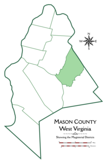
Cologne Magisterial District is one of ten magisterial districts in Mason County, West Virginia. The district was originally established as a civil township in 1863, and converted into a magisterial district in 1872. In 2010, Cologne District was home to 1,459 people.