Related Research Articles

Clay County is located in the U.S. state of Missouri and is part of the Kansas City metropolitan area. As of the 2020 census, the county had a population of 253,335, making it the fifth-most populous county in Missouri. Its county seat is Liberty. The county was organized January 2, 1822, and named in honor of U.S. Representative Henry Clay from Kentucky, later a member of the United States Senate and United States Secretary of State.
Wayne County is the westernmost county in the U.S. state of West Virginia. As of the 2020 census, the population was 38,982. Its county seat is Wayne. The county was founded in 1842 and named for General "Mad" Anthony Wayne.

Colonial Heights is an independent city in the Commonwealth of Virginia. As of the 2020 census, the population was 18,170. The Bureau of Economic Analysis combines the City of Colonial Heights with Dinwiddie County for statistical purposes.
Oakview and Oakview may refer to:
The West Deptford Public Schools is a comprehensive community public school district that serve students in pre-kindergarten through twelfth grade from West Deptford Township, in Gloucester County, in the U.S. state of New Jersey.

State Route 113 is an unsigned primary state highway in the U.S. state of Virginia. The state highway runs 1.33 miles (2.14 km) from U.S. Route 11E (US 11E), US 19, US 421, and SR 381 north to US 11 and US 19 within Bristol.

San Juan Unified School District is a school district in Sacramento County, California, that serves all or part of the following cities and unincorporated communities:

Brookwater is a suburb in the City of Ipswich, Queensland, Australia. It is one of the suburbs of the Greater Springfield Development. In the 2016 census Brookwater had a population of 2,151 people.
The Rural Municipality of Siglunes is a former rural municipality (RM) in the Canadian province of Manitoba. It was originally incorporated as a rural municipality on April 1, 1919. It ceased on January 1, 2015, as a result of its provincially mandated amalgamation with the RM of Eriksdale to form the Municipality of West Interlake.
Charlton Heights is a census-designated place (CDP) in Fayette County, West Virginia, United States. Charlton Heights is located on the north bank of the Kanawha River, 4 miles (6.4 km) southwest of Gauley Bridge. Charlton Heights has a post office with ZIP code 25040. As of the 2010 census, its population was 406.
Montgomery Heights is an unincorporated community in Fayette County, West Virginia, United States. Montgomery Heights is located on the south bank of the Kanawha River, 4.5 miles (7.2 km) southeast of Montgomery.
Tyler Heights, also known as Flatwoods, is an unincorporated community in Kanawha County, West Virginia, United States. Tyler Heights is located along West Virginia Route 622 at its junction with West Virginia Route 501, 5 miles (8.0 km) east-northeast of Nitro.
Logan Heights is an unincorporated community in Logan County, West Virginia, United States. It is part of the Mount Gay-Shamrock census-designated place.
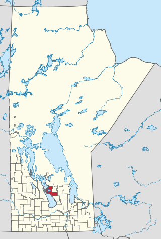
The Rural Municipality of West Interlake is a rural municipality (RM) in the Canadian province of Manitoba.
Oakview is a rural locality in the Gympie Region, Queensland, Australia. In the 2016 census Oakview had a population of 29 people. It is an historic mining area and now grazing country.
The following is a list of neighborhoods in Wichita, Kansas, United States.
Black Snake is a locality in the Gympie Region, Queensland, Australia. In the 2016 census, Black Snake had a population of 75 people.
References
Municipalities and communities of Wayne County, West Virginia, United States | ||
|---|---|---|
| Cities |  | |
| Towns | ||
| CDPs | ||
| Unincorporated communities |
| |
| Footnotes | ‡This populated place also has portions in an adjacent county or counties | |
| | This article about a location in Wayne County, West Virginia is a stub. You can help Wikipedia by expanding it. |