
The Williams–Woodland Park Local Historic District was established in 1985 and is a national historic district located at Fort Wayne, Indiana. The district encompasses 287 contributing buildings in a predominantly residential section of Fort Wayne located approximately one mile south of downtown. The area was developed from about 1875 to 1940, and includes notable examples of Colonial Revival, Prairie School, and Queen Anne style residential architecture.

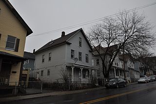
Eastside Park is a residential neighborhood in the Eastside of Paterson, New Jersey. The Eastside Park section of the city is generally defined as the area of the city bordered by Vreeland Avenue and East 33rd Street to the west, 20th Avenue to the south, McLean Boulevard to the east, and Martin Luther King, Jr. Way (Broadway) to the north. The Eastside Park section is delineated from the Manor section of the city by Broadway, which becomes Route 4 before crossing the Passaic River into Elmwood Park in Bergen County.
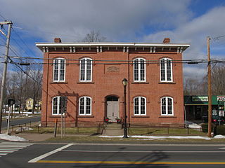
The Hazardville Historic District is a historic district in the Hazardville section of Enfield, Connecticut, United States, that is listed on the National Register of Historic Places.

There are nine historic districts in Meridian, Mississippi. Each of these districts is listed on the National Register of Historic Places. One district, Meridian Downtown Historic District, is a combination of two older districts, Meridian Urban Center Historic District and Union Station Historic District. Many architectural styles are present in the districts, most from the late 19th century and early 20th century, including Queen Anne, Colonial Revival, Italianate, Art Deco, Late Victorian, and Bungalow.
The Sterling Hill Historic District in Bridgeport, Connecticut is a historic district that was listed on the National Register of Historic Places in 1992. The district is a two-block area of 43 urban residential structures dating as far back as 1821. Most of the buildings are from later in the 19th century when the neighborhood was largely occupied by Irish working-class residents. Most of the early buildings are vernacular wood-frame structures with modest Federal, Greek Revival, or Gothic Revival details, while the later additions include multiunit tenement-style buildings. The area includes the oldest urbanized part of the city.

The Abell-Kilbourne House in Martinsburg, West Virginia is associated with John N. Abell, a prominent Martinsburg businessman and Charles W. Kilbourn, a Martinsburg mill owner. The former president of the Old National Bank, Abell developed the area known as "Abell's Addition" after his retirement in 1886. At that time Abell lived at 506 West Burke Street.

Aspen Hall, also known as the Edward Beeson House, was built beginning in 1771 as a stone house in the Georgian style in what would become Martinsburg, West Virginia. The first portion of the house was a 20 by 20 foot "fortified stone home", 2½ stories tall., in coursed rubble limestone built in 1745 by Edward Beeson I. It is the oldest house in Martinsburg.

The Boyd Avenue Historic District is a residential district comprising 80 houses in Martinsburg, West Virginia. The district includes the circa 1776 Aspen Hall and the associated Mendenhall's Fort of circa 1756. The district extends along Boyd Avenue 1,500 feet (460 m) from West Race Street to Aspen Hall. The older section of the street is a single 40-foot (12 m) right-of-way, while the newer portion is boulevarded, with a grassed median between two separate roads. The older section is significant from about 1888 to 1914, while the newer portion is significant from 1914 to the 1950s.
The Boomtown Historic District comprises the western and southern portions of Martinsburg, West Virginia, generally along the alignments of West King Street and Winchester Avenue, following the general path of the town's electric streetcar system. It includes a former industrial section of the town, home to a number of textile mills, as well as the housing that was built for mill workers.

The Boydville Historic District includes an area of Martinsburg, West Virginia that was developed for the well-to-do of Martinsburg at the turn of the twentieth century. The district is named for Boydville, the mansion at the core of the district. The district runs generally along South Queen Street to the south of the Downtown Martinsburg Historic District and to the east of the Boomtown Historic District.

The Baltimore and Ohio Related Industries Historic District comprises a portion of Martinsburg, West Virginia to either side of the Baltimore and Ohio Railroad line as it runs through the city. The district includes the Baltimore and Ohio Railroad Martinsburg Shops, a National Historic Landmark, and a variety of industrial and commercial concerns that depended on the railroad.
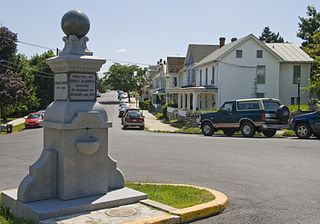
The Bunker Hill Historic District is the center of the town of Bunker Hill, West Virginia. Today located on the road called US 11, the town was developed along the Martinsburg, West Virginia - Winchester, Virginia road. Bunker Hill served southern Berkeley County with three stores, six mills, and five churches. It was also home to a significant African-American population.

The Hillside Historic District in Waterbury, Connecticut is a 106-acre (43 ha) historic district that was listed on the National Register of Historic Places (NRHP) in 1987. It encompasses a residential area north of the city's central business district, and is bounded on the south by West Main Street, the west by Willow Avenue and Cliff and Frederick Streets, on the north by Buckingham Street and Woodland Terrace, and on the east by Cook Street. Developed principally over an 80-year period between 1840 and 1920, it includes a cross-section of architectural styles of the 19th and early 20th centuries. The area was a desirable neighborhood of the city for much of this time, and was home to a number of the city's elite. In 1987, it included 395 buildings deemed to contribute to the historic character of the area, and one other contributing structure. It includes the Wilby High School and the Benedict-Miller House, which are both separately listed. 32 Hillside Road, a several acre property that includes the Benedict Miller House, was the original site of The University of Connecticut's Waterbury Branch until 2003.

The Downtown Adrian Commercial Historic District is a historic district comprising the downtown area of Adrian, Michigan. It was designated as a Michigan Historic Site and added to the National Register of Historic Places on April 17, 1986. The district is roughly bounded on the north by Toledo Street, on the east by North Broad Street, on the south by East Church Street, and on the west by North Winter Street (M-52), West Maumee Street, and the River Raisin. Most of the district is enclosed by the US-223 Business Route, although the two are not conterminous.
The Canton Center Historic District encompasses the historic rural town center of Canton, Connecticut. Extending mainly along Connecticut Route 179, near the geographic town center, is a well-preserved example of a rural agricultural center in Connecticut, a role served until about 1920. The district includes many examples of Late Victorian and Greek Revival architecture. It was listed on the National Register of Historic Places in 1997.
The Washington Street Historic District encompasses a residential area of Middletown, Connecticut that has a long history as a fashionable and desirable neighborhood. Extending along Washington Street and Washington Terrace between Main and Jackson Streets, the area has a broad diversity of residential architecture dating from 1752 to 1931, reflecting the city's patterns of growth. The district was listed on the National Register of Historic Places in 1985.

Downtown Martinsburg Historic District is a national historic district located at Martinsburg, Berkeley County, West Virginia. It encompasses 281 contributing buildings. It includes government and industrial buildings, several schools, firehouses, and churches, the two main commercial and professional areas along Queen and King Streets, a major hospital, and surrounding residential areas. The buildings reflect a number of popular 19th-century architectural styles including Gothic Revival, Italianate, and Queen Anne.
Martinsburg Mining, Manufacturing & Improvement Co. Historic District is a national historic district located at Martinsburg, Berkeley County, West Virginia. It encompasses 289 contributing buildings located within 19 city blocks and built between 1891 and 1952. It includes a residential area developed by the Martinsburg Mining, Manufacturing & Improvement Co. as worker housing. They are one to 2 1/2 story, single family, detached, semi-detached, and multi-unit housing built in wood frame, brick or brick veneer, and concrete block. Also located in the district is the Gothic Revival-style St. Luke's United Methodist Church. It includes examples of vernacular interpretations of popular architectural styles including Queen Anne, American Four Square, and Bungalow styles.
The Buena Vista Park Historic District in Tulsa, Oklahoma is a 5-acre (2.0 ha) historic district that was listed on the U.S. National Register of Historic Places (NRHP) in 2007. Its 24 contributing buildings include Late 19th and 20th Century Revivals and Late 19th and Early 20th Century American Movements architecture, specifically Colonial Revival architecture, Prairie School, and Bungalow/Craftsman architecture. The period of significance is 1913-1933.

Emerson Avenue Addition Historic District, also known as Emerson Heights Addition and Charles M. Cross Trust Clifford Avenue Addition, is a national historic district located at Indianapolis, Indiana. It encompasses 1,000 contributing buildings and 9 contributing objects in a planned residential section of Indianapolis. The district developed between about 1910 and 1949, and includes representative examples of Tudor Revival, Colonial Revival, and Bungalow / American Craftsman style residential architecture.


