East Point, Alabama

Last updated

East Point, Alabama
Cullman County Alabama Incorporated and Unincorporated areas East Point Highlighted 0122504.svg
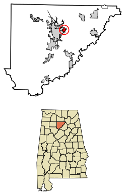
Location of East Point in Cullman County, Alabama.
USA Alabama location map.svg
Red pog.svg
East Point
Coordinates: 34°10′59″N86°47′37″W / 34.18306°N 86.79361°W / 34.18306; -86.79361
Country United States
State Alabama
County Cullman
Area
[1]
  Total0.98 sq mi (2.54 km2)
  Land0.97 sq mi (2.53 km2)
  Water0.01 sq mi (0.02 km2)
Elevation
810 ft (250 m)
Population
 (2020)
  Total172
  Density176.41/sq mi (68.11/km2)
Time zone UTC-6 (Central (CST))
  Summer (DST) UTC-5 (CDT)
Area code(s) 256 & 938
GNIS feature ID117784 [2]

East Point is a census-designated place and unincorporated community in Cullman County, Alabama, United States. Its population was 172 as of the 2020 census.

Demographics

Historical population
CensusPop.Note
2010 201
2020 172−14.4%
U.S. Decennial Census [3]

Related Research Articles

<span class="mw-page-title-main">Clay County, Illinois</span> County in Illinois, United States

Clay County is a county in the southeastern portion of the U.S. state of Illinois. As of the 2020 United States Census, the population was 13,288. Since 1842, its county seat has been Louisville, in the center of the county's area.

<span class="mw-page-title-main">Clay County, Mississippi</span> County in Mississippi, United States

Clay County is a county in the U.S. state of Mississippi. As of the 2020 census, the population was 18,636. Its county seat is West Point. Its name is in honor of American statesman Henry Clay, member of the United States Senate from Kentucky and United States Secretary of State in the 19th century. J. Wesley Caradine, an African American, was the first state representative for Clay County after it was established in 1871.

<span class="mw-page-title-main">Aleutians East Borough, Alaska</span> Borough in Alaska, United States

Aleutians East Borough is a 2nd class borough in the U.S. state of Alaska. As of the 2020 census the borough's population was 3,420. The borough seat is Sand Point.

<span class="mw-page-title-main">Churchill County, Nevada</span> County in Nevada, United States

Churchill County is a county in the western U.S. state of Nevada. As of the 2020 census, the population was 25,516. Its county seat is Fallon. Named for Mexican–American War hero brevet Brigadier General Sylvester Churchill, the county was formed in 1861. Churchill County comprises the Fallon, NV Micropolitan Statistical Area. It is in northwestern Nevada. Churchill County is noteworthy in that it owns and operates the local telephone carrier, Churchill County Communications.

<span class="mw-page-title-main">Providence County, Rhode Island</span> County in Rhode Island, United States

Providence County is the most populous county in the U.S. state of Rhode Island. As of the 2020 census, the county's population was 660,741, or 60.2% of the state's population. Providence County contains the city of Providence, the state capital of Rhode Island and the county's most populous city, with an estimated 190,934 residents in 2020. Providence County is included in the Providence-Warwick, RI-MA Metropolitan Statistical Area, which in turn constitutes a portion of the greater Boston-Worcester-Providence, MA-RI-NH-CT Combined Statistical Area. As of 2010, the center of population in Rhode Island is located in Providence County, in the city of Cranston.

<span class="mw-page-title-main">Columbiana County, Ohio</span> County in Ohio, United States

Columbiana County is a county located in the U.S. state of Ohio. As of the 2020 census, the population was 101,877. The county seat is Lisbon and its largest city is Salem. Created in 1803, the county name is derived from that of 15th-century Italian explorer Christopher Columbus.

<span class="mw-page-title-main">Washoe County, Nevada</span> County in Nevada, United States

Washoe County is a county in the U.S. state of Nevada. As of the 2020 census, the population was 486,492, making it Nevada's second-most populous county. Its county seat is Reno. Washoe County is included in the Reno, NV Metropolitan Statistical Area.

<span class="mw-page-title-main">Jackson County, Mississippi</span> County in Mississippi, United States

Jackson County is a county located in the U.S. state of Mississippi. As of the 2020 census, the population was 143,252, making it the fifth-most populous county in Mississippi. Its county seat is Pascagoula. The county was named for Andrew Jackson, general in the United States Army and afterward President of the United States.

<span class="mw-page-title-main">Dallas County, Iowa</span> County in Iowa, United States

Dallas County is a county located in the U.S. state of Iowa. As of the 2020 Census, the population was 99,678, making it the seventh-most populous county in Iowa. Between 2010 and 2020, it was the fastest growing county in Iowa and one of the fastest growing in the country. Its county seat is Adel, and its largest city is Waukee. The county was named for George M. Dallas, Vice President of the United States under James K. Polk, the namesake of neighboring Polk County.

<span class="mw-page-title-main">Shelby County, Illinois</span> County in Illinois, United States

Shelby County is a county located in the U.S. state of Illinois. According to the 2020 census, it had a population of 20,990. Its county seat is Shelbyville.

<span class="mw-page-title-main">Greene County, Georgia</span> County in Georgia, United States

Greene County is a county located in the east central portion & the Lake country region of the U.S. state of Georgia. As of the 2020 census, the population was 18,915. The county seat is Greensboro. The county was created on February 3, 1786, and is named for Nathanael Greene, an American Revolutionary War major general.

<span class="mw-page-title-main">Yuma County, Colorado</span> County in Colorado, United States

Yuma County is a county located in the U.S. state of Colorado. As of the 2020 census, the population was 9,988. The county seat is Wray.

<span class="mw-page-title-main">Stevens Point, Wisconsin</span> City in Wisconsin, United States

Stevens Point is the county seat of Portage County, Wisconsin, United States. The city was incorporated in 1858.

<span class="mw-page-title-main">East Point, Georgia</span> City in Georgia, United States

East Point is a suburban city located southwest of Atlanta in Fulton County, Georgia, United States. As of the 2020 census, the city had a population of 38,358. The city name is derived from being at the opposite end of the former Atlanta & West Point Railroad from West Point.

<span class="mw-page-title-main">Wareham, Massachusetts</span> Town in Massachusetts, United States

Wareham is a town in Plymouth County, Massachusetts, United States. As of the 2022 census, the town had a population of 23,303.

<span class="mw-page-title-main">West Coast of the United States</span> Coastline in the United States

The West Coast of the United States – also known as the Pacific Coast, and the Western Seaboard – is the coastline along which the Western United States meets the North Pacific Ocean. The term typically refers to the contiguous U.S. states of California, Oregon, and Washington, but sometimes includes Alaska and Hawaii, especially by the United States Census Bureau as a U.S. geographic division.

<span class="mw-page-title-main">Baton Rouge metropolitan area</span> Metropolitan area in Louisiana, United States

The Baton Rouge metropolitan statistical area, as defined by the United States Office of Management and Budget, or simply the Baton Rouge metropolitan area or Greater Baton Rouge, is a sprawling metropolitan statistical area surrounding the city of Baton Rouge. Including the western edge of the Florida Parishes regions, it is known as "Plantation Country", the "Capital Region", and "The 225". At the 2010 U.S. census, the metropolitan area had a population of 802,484, up from 705,973 in 2000. At the 2020 census, its population increased to 870,569, up from 2020 estimates at 858,571.

Michigan's 14th congressional district was a congressional district that stretched from eastern Detroit westward to Farmington Hills, then north to the suburb of Pontiac. From 1993 to 2013, it was based entirely in Wayne County.

<span class="mw-page-title-main">East Honolulu, Hawaii</span> Census-designated place in Hawaii, United States

East Honolulu is a census-designated place (CDP) located in Honolulu County, Hawaii, United States. As of the 2020 Census, the CDP had a population of 50,922, making it the 2nd most populated CDP in Hawaii, behind Honolulu.

References

  1. "2020 U.S. Gazetteer Files". United States Census Bureau. Retrieved October 29, 2021.
  2. "East Point". Geographic Names Information System . United States Geological Survey, United States Department of the Interior.
  3. "Census of Population and Housing". Census.gov. Retrieved June 4, 2016.