Blount County is a county located in the U.S. state of Alabama. As of the 2010 census, the population was 57,322. Its county seat is Oneonta.

Winston County is a county of the U.S. state of Alabama. As of the 2010 census, the population was 24,484. Its county seat is Double Springs. Known as Hancock County before 1858, the county is named in honor of John A. Winston, the fifteenth Governor of Alabama.

Lawrence County is a county in the northern part of the U.S. state of Alabama. As of the 2010 census, the population was 34,339. This county has the highest number of residents who identify as Native American of any county in the state. The county seat is Moulton. The county was named after James Lawrence, a captain in the United States Navy from New Jersey.

Garden City is a town in Blount and Cullman counties in the U.S. state of Alabama. At the 2010 census the population was 492. Garden City was founded by Johann Cullmann, namesake of Cullman County in 1873 after founding Cullman, Alabama. It was located in Blount County and was incorporated in 1878. Cullman County was created in 1877. Garden City was annexed by Cullman County with a shift in county borders until 1901. After a lapse in its incorporation, it was re-incorporated in 1950.
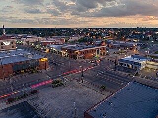
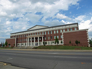
Cullman is a city in and the county seat of Cullman County, Alabama, United States. It is located along Interstate 65, about 50 miles (80 km) north of Birmingham and about 55 miles (89 km) south of Huntsville. As of the 2010 census it had a population of 14,775, with an estimated population of 15,385 in 2017.

U.S. Route 278 is a parallel route of U.S. Route 78. It currently runs for 1,074 miles (1,728 km) from Hilton Head Island, South Carolina to Wickes, Arkansas at U.S. Route 71/U.S. Route 59. It is longer than its parent highway, US 78. US 278 passes through the states of South Carolina, Georgia, Alabama, Mississippi, and Arkansas. This highway passes through the cities and towns of Augusta, Covington, Atlanta, Powder Springs, Hiram, Dallas, Rockmart, and Cedartown, Georgia; Gadsden and Cullman, Alabama; Tupelo, Oxford, and Greenville, Mississippi; and Monticello and Hope, Arkansas.
Bishop John Quinlan was a Roman Catholic bishop and the second Bishop of Mobile.
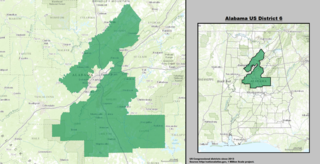
Alabama's 6th congressional district is a United States congressional district in Alabama that elects a representative to the United States House of Representatives. It is composed of the wealthier portions of Birmingham, nearly all of Jefferson County outside Birmingham, and the entirety of Bibb, Blount, Chilton, Coosa, and Shelby counties.

Brindlee Mountain is an isolated portion of the Appalachian Plateau in northern Alabama. It occupies significant portions of Cullman, Morgan, and Marshall Counties and extends into Winston and Lawrence counties. The plateau is formed by a sandstone cap-rock overlying limestone. The main mountain sits south of Lacey's Spring and houses communities such as Union Hill and Morgan City as well as parts of Union Grove and spans into Arab also. U.S. Route 231 runs over Brindlee Mountain. The highest point of Brindlee Mountain rests in Morgan City.
Cullman High School is the largest public high school in the city of Cullman, Alabama as well as Cullman County, Alabama. The school is classified as a 6A school and belongs to the Cullman City School District.

Lewis Smith Lake is a reservoir in north Alabama. Located on the Sipsey Fork of the Black Warrior River, it covers over 21,000 acres (85 km2) in Cullman, Walker, and Winston Counties. The maximum depth at the dam is 264 feet. The three-fingered reservoir has over 500 miles (800 km) of shoreline, and at full pool has a level of 510 feet (160 m).
Crane Hill is an unincorporated community in Cullman County, Alabama, United States, located in the southwestern portion of the county. The community of Crane Hill can trace its history back to 1806, when the first settlers recorded their land titles. This area is named after the Sandhill Crane who fished the streams and roosted on a hill located just north of Mt. Zion Road and part of the Kirby Lay property. It was from this large hill of roosting cranes that Crane Hill took its name.
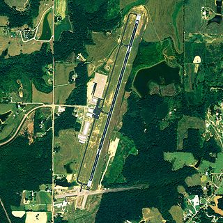
Cullman Regional Airport-Folsom Field is a public-use airport located five nautical miles north of the central business district of Cullman, a city in Cullman County, Alabama, United States. It is owned by the City and County of Cullman.
Arkadelphia is an unincorporated community located in far southern Cullman County, Alabama, United States. It is situated just a few miles southwest of the town of Colony.

The Birmingham metropolitan area, sometimes known as Greater Birmingham, is a metropolitan area in north central Alabama centered on Birmingham, Alabama.

Joppa is a census-designated place (CDP) and unincorporated community in Cullman and Marshall counties, Alabama, United States. As of the 2010 census, its population was 501.
Black Bottom is an unincorporated community in Cullman County, Alabama, United States, located near the junction of Interstate 65 and Alabama State Route 91, 2.4 miles (3.9 km) east of Colony.
Simcoe is an unincorporated community in Cullman County, Alabama, United States, located on Alabama State Route 69, 3.7 miles (6.0 km) southwest of Fairview.
Walter is an unincorporated community in Cullman County, Alabama, United States. Walter is located on Alabama State Route 91, 7.2 miles (11.6 km) northeast of Hanceville.