East Suffolk line

Last updated

East Suffolk line
Boss Hall - Greater Anglia 156419.jpg
156419 crossing a bridge near Boss Hall
Overview
StatusOperational
Owner Network Rail
Locale Suffolk,
East of England
Termini
Stations12
Service
Type Heavy rail
System National Rail
Operator(s) Greater Anglia
Rolling stock Class 755 FLIRT
Former rolling stock:
British Rail classes 153, 156 and 170
History
Opened1854
Technical
Line length48 miles 75 chains (78.8 km)
Number of tracks1-2
Character Rural branch line
Track gauge 4 ft 8+12 in (1,435 mm) standard gauge
Operating speed55 mph (89 km/h)
Route map
East Suffolk line.png
(Click to expand)

The East Suffolk line is an un-electrified 49-mile secondary railway line running between Ipswich and Lowestoft in Suffolk, England. The traffic along the route consists of passenger services operated by Greater Anglia, while nuclear flask trains for the Sizewell nuclear power stations are operated by Direct Rail Services.

Contents

The Halesworth, Beccles and Haddiscoe Railway opened between those points in 1854, and the East Suffolk Railway took over and extended southwards to Ipswich and north and east to Lowestoft and Great Yarmouth, opening in 1859, and forming a more direct route to London from the coastal towns. There were branches to Framlingham, Snape Bridge and in 1860 to Aldeburgh. In 1862 the East Suffolk Railway company was folded into the new Great Eastern Railway.

The GER operated a successful passenger and goods train service, and with the development of seaside holidays in the latter part of the nineteenth century, and further in the twentieth, the seasonal passenger traffic increased considerably; goods traffic was limited by the predominantly rural and agricultural topography, with some notable pockets of industry, and considerable fishery traffic.

After 1945 use of the line declined and costs escalated sharply, and it appeared likely that the network would be closed, but the East Suffolk Railway main line was reprieved in 1966. Pioneering cost reduction measures were implemented from that time and in later years, and through express trains were moved to other routes. Sizewell nuclear power stations brought construction traffic to the line, and nuclear flasks are still handled at intervals. At present the line carries an hourly passenger service, consisting of British Rail class 755 bi-mode multiple units.

History

The Lowestoft and Beccles Railway, and the Lowestoft and Haddiscoe Railway were incorporated into the East Suffolk Railway in 1858. The combined network opened a year later. It later became part of the Great Eastern Railway. A branch to Southwold operated between 1879 and 1929.

In the 1950s and 1960s, the Snape and Beccles branches closed and the line was rationalised under the Beeching Axe. From the 1960s onwards, construction trains and later atomic flask trains ran on a branch from Saxmundham to Sizewell nuclear power station. [1]

Recent infrastructure developments

Until October 2012, the section from Westerfield to Oulton Broad was signalled using Radio Electronic Token Block controlled from Saxmundham. However, due to radio frequency licensing issues, and the imminent beginning of an hourly train service on the line, which would have been beyond the capacity of RETB, Track Circuit Block signalling (using AzLM axle counters) has replaced the RETB system, after the last train on 19 October 2012. The new signalling came into operation on 23 October 2012, controlled from the existing signal box at Saxmundham. On 10 December 2012 a new passing loop and reinstated second platform opened at Beccles. [2]

In December 2010 through trains from Lowestoft to London via the East Suffolk Line were terminated. From December 2012 an hourly service over the East Suffolk line was introduced following the completion of the passing loop at Beccles.

Bacon Factory Curve

A connecting curve from north to east near East Suffolk Junction opened in 2014. The 1.2 km (34 mi) line north-west of Ipswich railway station makes a direct connection between the East Suffolk Line and the Great Eastern Main Line and removed the need for Midlands freight trains travelling to and from Felixstowe to run round in sidings. It is a double track chord and was built on part of the site of a former Harris meat factory and has been given the official name Bacon Factory Curve. The connections at each end have been named Europa Junction (at the GER main line end) and Boss Hall Junction (at the Westerfield Road end). It reduced the number of freight trains running south from Ipswich to access the Midlands via the North London Line by enabling easier access to the line via Bury St Edmunds and March. [3] [4] It is commonly nicknamed "the Bacon bend" or "the Harris curve" by locals to the area.

Current services

The route has a regular hourly passenger service from Ipswich to Lowestoft, operated by three- or four-coach Class 755 bi-mode multiple units.

Services from Felixstowe operate between Westerfield and Ipswich East Suffolk Junction on the south end of the line, and this section is also extremely busy with container trains to and from the Port of Felixstowe. The only other freight services run to Sizewell power station.

Accidents

On 26 September 1865 a light engine returning from Great Yarmouth to Ipswich derailed between Darsham and Halesworth, killing the driver and fireman. [5]

Saxmundham Station circa 1901 Saxmundham Station circa 1901 - geograph.org.uk - 926665.jpg
Saxmundham Station circa 1901

At 8.45 am on 25 September 1900 a GER Class Y14 0-6-0 locomotive no 522 suffered a boiler explosion at Westerfield, killing the driver John Barnard and his fireman William Macdonald. The boiler was thrown 40 yards forwards, over the level crossing, and ended up on the down platform. The locomotive had a history of boiler problems. The victims were buried in Ipswich cemetery and both their gravestones have a likeness of a Y14 0-6-0 carved onto them. [6] [7]

On 1 January 1927 there was a train crash at Woodbridge station. A wagon coupling had broken at Bealings and when the engine stopped at Woodbridge, the rear portion running downhill smashed into the back of the stationary train. One minor injury was recorded. [8]

Current route

The line today runs north from Ipswich via Westerfield, Woodbridge, Melton, Wickham Market, Saxmundham, Darsham, Halesworth, Brampton, Beccles, Oulton Broad South, and Lowestoft. It connects with the Great Eastern Main Line at Ipswich, the Felixstowe branch line at Westerfield, the line to Sizewell Power Station at Saxmundham, and the Norwich line at Lowestoft; the passenger service on the Norwich route is marketed as the Wherry Lines.

The line is double track from Ipswich to Woodbridge and then single to Saxmundham; from there it is double track as far as Halesworth, and then single again. There is a passing loop at Beccles, but the single line continues as far as Oulton Broad North Junction, where it joins the line from Norwich for the final entry to Lowestoft. The line is not electrified; it has a loading gauge of W10 between Ipswich and Westerfield and W6 for all other sections, and a maximum permissible speed of line of 55 mph. [9]

Location list

Main line:

Framlingham branch:

Snape branch line:

Aldeburgh branch line:

Lowestoft and Beccles railway:

Haddiscoe to Lowestoft link (via the Lowestoft Railway):

Haddiscoe connection:

Operations

Greater Anglia passenger services are operated by Class 755 "FLIRT". Freight to Sizewell on the former Aldeburgh branch line is typically operated by Class 37 or Class 20s, while Class 66 and Class 70s work trains to Felixstowe.

Signal boxes

The following is a list of signal boxes operational during the steam and early years of the diesel era. They are listed south to north and in 2023 only Saxmundham is still operational.

Previous infrastructure items

Two of the stations on the line had level crossings incorporated into the platforms. At Saxmundham the original down platform (the platforms here were staggered rather than opposite each other) required extension for longer trains and rather than close the Chantry Road, the platform acted as a gate and were swung across the railway when road access was required. A train hit the road gate in the early 1960s and the platform was replaced by more conventional gates. By this time the railway had become a secondary route and the longer platform was not required. [16]

A similar arrangement was at Halesworth where the platforms were extended in 1887. Increasing road traffic in the 1950s resulted in a new road bridge being built to the north of the station. The level crossing was closed in 1959 although the gates remained as part of the platform for some years. [17]

The movable platform at Halesworth station, c. 2008 Movable Platforms at Halesworth Station - geograph.org.uk - 1034529.jpg
The movable platform at Halesworth station, c. 2008

At Beccles there was an unusual draw bridge arrangement which allowed milk churns and barrows to be moved from the main platform to the island platform. This was installed in 1933 and was located at the south end of the station. When not in use the bridge formed part of the platform surface. [18]

At Woodbridge there was long siding (referred to as a tramway) which ran alongside the East Suffolk line for 41 chains (820 m) towards Melton. Serving a number of riverside industries and open until the 1950s it was notable as being worked by shunting horses rather than locomotives. [19]

Southwold Railway Trust

The Southwold Railway Trust is "committed to restoring the historic narrow gauge railway link between Halesworth & Southwold; preserving it for future generations to enjoy." [20]

Notes

    Related Research Articles

    Leiston is an town in the East Suffolk district of Suffolk, England. It is close to Saxmundham and Aldeburgh, 21 miles (34 km) north-east of Ipswich and 90 miles (145 km) north-east of London. The town had a population of 5,508 at the 2011 Census.

    <span class="mw-page-title-main">East Suffolk (county)</span> Former county in eastern England

    East Suffolk, along with West Suffolk, was created in 1888 as an administrative county of England. The administrative county was based on the eastern quarter sessions division of Suffolk. East Suffolk County Council's headquarters were at East Suffolk County Hall in Ipswich.

    <span class="mw-page-title-main">Lowestoft railway station</span> Railway station in Suffolk, England

    Lowestoft railway station serves the town of Lowestoft, Suffolk. It is the eastern terminus of the East Suffolk Line from Ipswich and is one of two eastern termini of the Wherry Lines from Norwich. Lowestoft is 23 miles 41 chains (37.8 km) down the line from Norwich and 48 miles 75 chains (78.8 km) measured from Ipswich; it is the easternmost station on the National Rail network in the United Kingdom.

    <span class="mw-page-title-main">Oulton Broad South railway station</span> Railway station in Suffolk, England

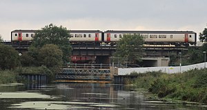
    Oulton Broad South railway station is on the East Suffolk Line in the east of England, and is one of two stations serving Oulton Broad, Suffolk. The other is Oulton Broad North on the Wherry Lines. Oulton Broad South is the next station along from Lowestoft on the line to Ipswich, and from Lowestoft the line crosses Mutford Bridge with a view of Lake Lothing to the east and Oulton Broad Lake to the west. The station is 115 miles 42 chains (185.9 km) measured from London Liverpool Street via Ipswich.

    <span class="mw-page-title-main">Beccles railway station</span> Railway station in Suffolk, England

    Beccles railway station is on the East Suffolk Line in the east of England, serving the town of Beccles, Suffolk. It is 40 miles 34 chains (65.1 km) down the line from Ipswich and 109 miles 11 chains (175.6 km) measured from London Liverpool Street; it is situated between Brampton and Oulton Broad South stations. Its three-letter station code is BCC.

    <span class="mw-page-title-main">Derby Road railway station</span> Railway station in Suffolk, England

    Derby Road railway station (also known as Derby Road (Ipswich)) is on the Felixstowe Branch Line in the east of England, serving the Rose Hill area and southern area of California on the eastern side of the town of Ipswich, Suffolk. It is 6 miles 8 chains (9.8 km) down the line from Ipswich station and 74 miles 67 chains (120.4 km) measured from London Liverpool Street; It is situated between Westerfield and Trimley and is managed by Greater Anglia, which also operates all passenger trains that call.

    <span class="mw-page-title-main">Westerfield railway station</span> Railway station in Suffolk, England

    Westerfield railway station is on a branch line off the Great Eastern Main Line, in the East of England, serving the village of Westerfield, Suffolk. It is 3 miles 41 chains (5.7 km) from Ipswich and 72 miles 25 chains (116.4 km) from London Liverpool Street. It is situated at the junction of the Felixstowe Branch Line to Felixstowe, and the East Suffolk Line to Lowestoft. Its three-letter station code is WFI.

    <span class="mw-page-title-main">Ipswich railway station</span> Railway station in Suffolk, England

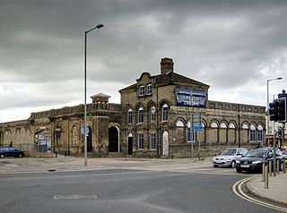
    Ipswich railway station is on the Great Eastern Main Line in the East of England, serving the town of Ipswich, Suffolk. It is 68 miles 59 chains (110.6 km) down the line from London Liverpool Street and, on the main line, it is situated between Manningtree to the south and Needham Market to the north.

    <span class="mw-page-title-main">Saxmundham railway station</span> Railway station in Suffolk, England

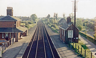
    Saxmundham railway station is on the East Suffolk Line in the east of England, serving the town of Saxmundham, Suffolk. Situated between Wickham Market and Darsham, it is 22 miles 29 chains (36 km) down the line from Ipswich, and 91 miles 11 chains (147 km) from London Liverpool Street. Its three-letter station code is SAX.

    <span class="mw-page-title-main">Brampton railway station (Suffolk)</span> Railway station in Suffolk, England

    Brampton railway station is on the East Suffolk Line in the east of England, serving the villages of Brampton, Redisham and surrounding hamlets in Suffolk. It is 35 miles 70 chains (57.7 km) down the line from Ipswich and 104 miles 49 chains (168.4 km) measured from London Liverpool Street; it is situated between Halesworth and Beccles. It is commonly suffixed as Brampton (Suffolk) in order to distinguish it from the station of the same name in Cumbria.

    <span class="mw-page-title-main">Yarmouth South Town railway station</span> Former railway station in Norfolk, England

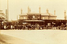
    Yarmouth South Town, sometimes known as Yarmouth Southtown, was a railway station in Great Yarmouth, Norfolk, England. It was one of three major stations in the town; the others being Yarmouth Vauxhall and Yarmouth Beach, of which only the former remains.

    <span class="mw-page-title-main">Aldeburgh railway station</span> Former station in Suffolk, England

    Aldeburgh railway station was a station in Aldeburgh, Suffolk, England. It was opened in 1860 by the East Suffolk Railway, and later came under the control of the Great Eastern Railway. The terminus of an 8.5-mile branch line to Saxmundham, the station closed in 1966 as part of the Beeching Axe as much of the British rural rail network was cut back.

    <span class="mw-page-title-main">Aldeburgh branch line</span> Disused railway line in East Suffolk

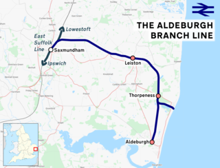
    The Aldeburgh branch line was a railway branch line linking the town of Saxmundham on the East Suffolk line and the seaside resort of Aldeburgh. There were intermediate stops at Leiston and Thorpeness. Part of the line remains in use for nuclear flask trains servicing Sizewell nuclear power station.

    The Yarmouth–Beccles line was a railway line which linked the Suffolk market town of Beccles with the Norfolk coastal resort of Yarmouth. Forming part of the East Suffolk Railway, the line was opened in 1859 and closed 100 years later in 1959.

    The Framlingham branch was a six-mile (9.7 km) single-track branch railway line from Wickham Market railway station on the East Suffolk Line to Framlingham, with three intermediate stations, Parham, Hacheston Halt, and Marlesford.

    <span class="mw-page-title-main">A1094 road</span> Road in Suffolk, England

    The A1094 is an A road in the English county of Suffolk. It is around 7 miles (11 km) in length. The road runs from a junction off the A12 trunk road at Friday Street in Benhall to Aldeburgh on the North Sea coast. The road is single carriageway throughout.

    The East Suffolk line is a railway in East Anglia with a long history.

    References

    1. Peter Paye, The Aldeburgh Branch, Oakwood Press, Usk, 2012, ISBN   978 0 85361 723 5
    2. Network Rail. "New hourly service on East Suffolk line". Network Rail Media Centre (Press release). Archived from the original on 15 April 2014. Retrieved 10 December 2012.
    3. Ipswich east-west freight chord opens in the Railway Magazine, April 2014
    4. Johnson, Marc. "Ipswich chord and freight yard". Rail Engineer UK. Rail Engineer. Archived from the original on 24 September 2015. Retrieved 24 June 2015.
    5. Cooper 1982, p. 29.
    6. Freestone, Jill; Smith, Richard W. (1998). Ipswich Engines and Ipswich Men. Ipswich: Under Stoke History group. ISBN   0-9532257-0-4.
    7. Accident Returns: Extract for the Accident at Westerfield on 25th September 1900 (PDF). p. 74 via Railways Archive.
    8. Cooper 1982, p. 33.
    9. Network Rail: Anglia Route Sectional Appendix, updated to March 2018.
    10. M E Quick, Railway Passenger Stations in England Scotland and Wales—A Chronology, The Railway and Canal Historical Society, 2002
    11. Neil Burgess, Suffolk’s Lost railways, Stenlake publishing, Catrine, 2011 ISBN   978 1 840 335 385
    12. Adderson & Kenworthy 2005, p. 19.
    13. Wilson, Bryan (July 2001). "photo caption". Great Eastern Journal. 107: 11.
    14. Adderson & Kenworthy 2004, p. 32.
    15. Adderson & Kenworthy 2004, map IX.
    16. Adderson & Kenworthy 2004, Figs 16/20/21.
    17. Adderson & Kenworthy 2005, figs 113/114.
    18. Adderson & Kenworthy 2004, Figs 40/1.
    19. Adderson & Kenworthy 2005, figs 44/46.
    20. https://www.southwoldrailway.co.uk/ Southwold Railway Trust website