Related Research Articles

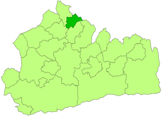
Dover is a local government district in Kent, England. It is named after its largest town, the port town of Dover. The council is based in Whitfield on the outskirts of Dover. The district also covers the towns of Deal, Sandwich and Walmer as well as the surrounding rural areas.

Buckingham Rural District was a rural district in the administrative county of Buckinghamshire, England from 1894 to 1974, covering an area in the north-west of the county. It was named after but did not include the borough of Buckingham.
Winslow Rural District was a rural district in the administrative county of Buckinghamshire, England from 1894 to 1974, covering an area in the north of the county.

Walthamstow was a local government district in southwest Essex, England from 1873 to 1965, around the town of Walthamstow. It was within the London suburbs, forming part of the London postal district and Metropolitan Police District. Its former area now corresponds to the central part of the London Borough of Waltham Forest in Greater London. Its population and area grew rapidly as London continued to develop its suburbs.

Potters Bar Urban District was a local government district in England from 1894 to 1974, covering the town of Potters Bar and the village of South Mimms. The district was initially called the South Mimms Rural District, being renamed in 1934.
Watford Rural District was a rural district in Hertfordshire from 1894 to 1974. It initially surrounded but did not include the town of Watford, which was a separate urban district. It gradually ceded territory to other districts, and by the time of its abolition in 1974 the district comprised three separate pieces of land, lying to the north-west, north-east, and south of Watford.

Luton Rural District was a local authority in Bedfordshire, England from 1894 to 1974. It covered an area which almost surrounded but did not include the towns of Luton and Dunstable.

The Local Government Act 1894 was an Act of the Parliament of the United Kingdom that reformed local government in England and Wales outside the County of London. The Act followed the reforms carried out at county level under the Local Government Act 1888. The 1894 legislation introduced elected councils at district and parish level.
Sanitary districts were established in England and Wales in 1872 and in Ireland in 1878. The districts were of two types, based on existing structures:
Romford Rural District was a local government district in southwest Essex, England from 1894 to 1934. It surrounded, but did not include, Romford which formed a separate urban district. During the life of the district the area changed in use from rural farm land to sprawling London suburb and in 1926 much of it was removed to form new urban districts.
Sunbury on Thames Urban District, also known as Sunbury Urban District, was a local government district from 1894 to 1974 comprising the town and parish of Sunbury-on-Thames and from 1930 also the parishes of Littleton and Shepperton.
Eaton Bray was a rural district in Bedfordshire, England from 1894 to 1933.
Hitchin Rural District was a rural district in Hertfordshire, England from 1894 to 1974, covering an area in the north of the county.
The History of local government districts in Middlesex outside the metropolitan area began in 1835 with the formation of poor law unions. This was followed by the creation of various forms of local government body to administer the rapidly growing towns of the area. By 1934 until its abolition in 1965, the entire county was divided into urban districts or municipal boroughs.

Hertford Rural District was a rural district in Hertfordshire, England from 1894 to 1974. It covered the rural area around the county town of Hertford, but did not include the town itself.
St Albans Rural District was a rural district in the administrative county of Hertfordshire, England from 1894 to 1974. It surrounded but did not include the city of St Albans.
The History of local government districts in Buckinghamshire began in 1835 with the formation of poor law unions. This was followed by the creation of various forms of local government body. In 1894 the existing arrangements were replaced with a system of municipal boroughs, urban and rural districts, which remained in place until 1974. Between 1974 and 2020 there were five non-metropolitan districts in the county, one of which became a unitary authority in 1997. The other four districts were abolished in 2020 when the rest of the county was placed under the Buckinghamshire Council unitary authority.
Ware Rural District was a rural district in Hertfordshire, England from 1894 to 1974, covering an area in the east of the county.
Chipping Norton Rural District was a rural district in Oxfordshire, England from 1894 to 1974. It surrounded but did not include the town of Chipping Norton.
Witney Rural District was a rural district in Oxfordshire, England from 1894 to 1974. It surrounded but did not include the town of Witney.
References
- ↑ Local Government Act 1894, as enacted
- ↑ Public Health Act 1875, as enacted
- ↑ Minutes of Wingham Highway Board, 20 May 1880, Kent County Archives HB/W2, p.83–86
- ↑ Eastry RD in Vision of Britain https://www.visionofbritain.org.uk/unit/10001754 (Relationships and changes tab)