Eastshore, Kansas

Last updated

Eastshore, Kansas
Map of Marion Co, Ks, USA.png
USA Kansas location map.svg
Red pog.svg
Eastshore
Usa edcp location map.svg
Red pog.svg
Eastshore
Coordinates: 38°22′55″N97°04′26″W / 38.3819584°N 97.0739122°W / 38.3819584; -97.0739122 [1]
Country United States
State Kansas
County Marion
Township Gale
Founded1969
Platted 1969
Elevation
[1]
1,381 ft (421 m)
Population
 (2020) [2]
  Total92
Time zone UTC-6 (CST)
  Summer (DST) UTC-5 (CDT)
Area code 620
FIPS code 20-19700
GNIS ID 2804496 [1]

Eastshore is an unincorporated community in Marion County, Kansas, United States. [1] As of the 2020 census, the population of the community and nearby areas was 92. [2] The community name comes from it being near the east shore of the Marion Reservoir. It is located north of the intersection of Pawnee Road and 210th Street.

Contents

History

Early history

For many millennia, the Great Plains of North America was inhabited by nomadic Native Americans. From the 16th century to 18th century, the Kingdom of France claimed ownership of large parts of North America. In 1762, after the French and Indian War, France secretly ceded New France to Spain, per the Treaty of Fontainebleau.

19th century

In 1802, Spain returned most of the land to France. In 1803, most of the land for modern day Kansas was acquired by the United States from France as part of the 828,000 square mile Louisiana Purchase for 2.83 cents per acre.

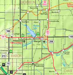
In 1806, Zebulon Pike led the Pike Expedition westward from St Louis, Missouri, of which part of their journey followed the Cottonwood River through Marion County near the current cities of Florence, Marion, Durham, and the community of Eastshore. [3]

In 1854, the Kansas Territory was organized, then in 1861 Kansas became the 34th U.S. state. In 1855, Marion County was established within the Kansas Territory, which included the land for modern day Eastshore. [4]

20th century

From 1964 to 1968, the Marion Reservoir was constructed. Eastshore was platted on October 13, 1969. [5]

Geography

Eastshore is located at coordinates 38.3819584, -97.0739122 in the scenic Flint Hills and Great Plains of the state of Kansas. [1] It lies immediately east of the Marion Cove of the Marion Reservoir. [6] [7]

Climate

The climate in this area is characterized by hot, humid summers and generally mild to cool winters. According to the Köppen Climate Classification system, Eastshore has a humid subtropical climate, abbreviated "Cfa" on climate maps. [8]

Demographics

Historical population
CensusPop.Note
2020 92
U.S. Decennial Census

For statistical purposes, the United States Census Bureau has defined Eastshore as a census-designated place (CDP).

2020 census

The 2020 United States census counted 92 people, 50 households, and 41 families in Eastshore. [9] [10] The population density was 0.1 per square mile (0.0/km2). There were 70 housing units at an average density of 0.1 per square mile (0.0/km2). [10] [11] The racial makeup was 92.39% (85) white or European American (91.3% non-Hispanic white), 0.0% (0) black or African-American, 2.17% (2) Native American or Alaska Native, 2.17% (2) Asian, 1.09% (1) Pacific Islander or Native Hawaiian, 0.0% (0) from other races, and 2.17% (2) from two or more races. [12] Hispanic or Latino of any race was 4.35% (4) of the population. [13]

Of the 50 households, 18.0% had children under the age of 18; 80.0% were married couples living together; 4.0% had a female householder with no spouse or partner present. 16.0% of households consisted of individuals and 6.0% had someone living alone who was 65 years of age or older. [10] The average household size was 1.9 and the average family size was 1.9. [14]

10.9% of the population was under the age of 18, 3.3% from 18 to 24, 13.0% from 25 to 44, 26.1% from 45 to 64, and 46.7% who were 65 years of age or older. The median age was 63.0 years. For every 100 females, there were 95.7 males. [10] For every 100 females ages 18 and older, there were 105.0 males. [10]

Area attractions

Education

The community is served by Marion–Florence USD 408 public school district. All students attend schools in Marion. The high school is a member of T.E.E.N., a shared video teaching network between five area high schools. [15]

Media

Print

Infrastructure

Transportation

U.S. Route 56 runs 1.33 miles (2.14 km) south of the community.

Utilities

Related Research Articles

<span class="mw-page-title-main">Cassoday, Kansas</span> City in Butler County, Kansas

Cassoday is a city in Butler County, Kansas, United States. It is known as the "Prairie Chicken Capital of the World". As of the 2020 census, the population of the city was 113.

<span class="mw-page-title-main">Elmdale, Kansas</span> City in Chase County, Kansas

Elmdale is a city in Chase County, Kansas, United States. As of the 2020 census, the population of the city was 40. It is located along U.S. Route 50 highway.

<span class="mw-page-title-main">Matfield Green, Kansas</span> City in Chase County, Kansas

Matfield Green is a city in Chase County, Kansas, United States. As of the 2020 census, the population of the city was 49. It is located along K-177 highway.

<span class="mw-page-title-main">North Newton, Kansas</span> City in Harvey County, Kansas

North Newton is a city in Harvey County, Kansas, United States. As of the 2020 census, the population of the city was 1,814. It is located between the north side of the city of Newton and the south side of Interstate I-135. North Newton is home of Bethel College.

<span class="mw-page-title-main">Burns, Kansas</span> City in Marion County, Kansas

Burns is a city in Marion County, Kansas, United States. As of the 2020 census, the population of the city was 234. The city name came from a nearby train station, which was named prior to the city being incorporated. It is located between El Dorado and Florence along the west side of U.S. Route 77 highway. The south edge of the city is the border of Marion and Butler counties.

<span class="mw-page-title-main">Durham, Kansas</span> City in Marion County, Kansas

Durham is a city in Marion County, Kansas, United States. As of the 2020 census, the population of the city was 89. The city took its name from Durham cattle. It is located about 8.5 miles (14 km) north of Hillsboro on the west side of K-15 highway next to a railroad.

<span class="mw-page-title-main">Florence, Kansas</span> City in Marion County, Kansas

Florence is a city in Marion County, Kansas, United States. As of the 2020 census, the population of the city was 394. The city was named after the daughter of the third Governor of Kansas Samuel J. Crawford. It is located at the intersection of U.S. Route 50 and U.S. Route 77 highways.

<span class="mw-page-title-main">Goessel, Kansas</span> City in Marion County, Kansas

Goessel is a city in Marion County, Kansas, United States. As of the 2020 census, the population of the city was 556. The city was named after Captain Kurt von Goessel (1852–1895) who went down with his ship, the Elbe, in the English Channel after it was rammed. It is located about 11 miles north of North Newton on the west side of K-15 highway.

<span class="mw-page-title-main">Hillsboro, Kansas</span> City in Marion County, Kansas

Hillsboro is a city in Marion County, Kansas, United States. As of the 2020 census, the population of the city was 2,732. The city was named after John Hill, who homesteaded in the area in 1871. Hillsboro is home of Tabor College.

<span class="mw-page-title-main">Lehigh, Kansas</span> City in Marion County, Kansas

Lehigh is a city in Marion County, Kansas, United States. As of the 2020 census, the population of the city was 161. It is located between Hillsboro and Canton on the north side of U.S. Route 56.

<span class="mw-page-title-main">Lincolnville, Kansas</span> City in Marion County, Kansas

Lincolnville is a city in Marion County, Kansas, United States. As of the 2020 census, the population of the city was 168. The city was named after Abraham Lincoln, the 16th president of the United States. It is located northeast of Marion, west of the intersection of U.S. Route 77 highway and 290th Street next to the Union Pacific Railroad.

<span class="mw-page-title-main">Lost Springs, Kansas</span> City in Marion County, Kansas

Lost Springs is a city in Marion County, Kansas, United States. As of the 2020 census, the population of the city was 55. The city was named for a nearby lost spring that was a camping spot along the 19th century Santa Fe Trail. It is located south of Herington, about 0.6 miles west of the intersection of U.S. Route 77 highway and 340th Street next to the Union Pacific Railroad.

<span class="mw-page-title-main">Marion, Kansas</span> City in Marion County, Kansas

Marion is a city in, and the county seat of, Marion County, Kansas, United States. As of the 2020 census, the population of the city was 1,922. The city was named in honor of Francis Marion, a brigadier general of the American Revolutionary War, known as the "Swamp Fox".

<span class="mw-page-title-main">Ramona, Kansas</span> City in Marion County, Kansas

Ramona is a city in Marion County, Kansas, United States. As of the 2020 census, the population of the city was 78. The city name is a Spanish name. It is located southwest of Herington next to a railroad.

<span class="mw-page-title-main">Galva, Kansas</span> City in McPherson County, Kansas

Galva is a city in McPherson County, Kansas, United States. As of the 2020 census, the population of the city was 834.

<span class="mw-page-title-main">Burdick, Kansas</span> Unincorporated community in Morris County, Kansas

Burdick is an unincorporated community in Morris County, Kansas, United States. It was named after Ms. Burdick, the sweetheart of a Santa Fe Railroad official in 1887. As of the 2020 census, the population of the community and nearby areas was 62. It is located southeast of Herington, about 5.6 miles (9.0 km) east of the intersection of U.S. Route 77 highway and 340th Street, or about 6.5 miles (10.5 km) east of Lost Springs.

<span class="mw-page-title-main">Pilsen, Kansas</span> Unincorporated community in Marion County, Kansas

Pilsen is an unincorporated community in Marion County, Kansas, United States. As of the 2020 census, the population of the community and nearby areas was 65. The community is named after the city Plzeň in Czech Republic, formerly Bohemia. It is located north of Marion and west of Lincolnville at the intersection of Remington Road and 275th Street.

<span class="mw-page-title-main">Canada, Kansas</span> Unincorporated community in Marion County, Kansas

Canada is an unincorporated community in Marion County, Kansas, United States. It is named for many Canadian immigrants coming to the area. It is located between Hillsboro and Marion about 0.5 miles south of the intersection of Nighthawk Road and U.S. Route 56 highway, southwest of the Hillsboro Cove of the Marion Reservoir.

<span class="mw-page-title-main">Marion Reservoir</span> Reservoir in Marion County, Kansas

Marion Reservoir is a body of water on the Cottonwood River, 3 miles (4.8 km) north-west of Marion on the western edge of the Flint Hills region of Kansas in the United States. The reservoir was completed in 1968 for flood control and is operated by the Army Corps of Engineers.

<span class="mw-page-title-main">Furley, Kansas</span> Unincorporated community in Sedgwick County, Kansas

Furley is an unincorporated community in Sedgwick County, Kansas, United States. As of the 2020 census, the population of the community and nearby areas was 39. It is located northwest of the intersection of Greenwich Road and 101st Street N, along the Union Pacific Railroad.

References

  1. 1 2 3 4 5 U.S. Geological Survey Geographic Names Information System: Eastshore, Kansas
  2. 1 2 "Profile of Eastshore, Kansas (CDP) in 2020". United States Census Bureau. Archived from the original on November 11, 2021. Retrieved November 11, 2021.
  3. "1806 Pike Expedition map through Marion County" (PDF). Archived from the original (PDF) on March 17, 2012. Retrieved April 13, 2013.
  4. "The History of Marion County and Courthouse". Archived from the original on February 27, 2018. Retrieved April 23, 2014.
  5. Marion County Kansas, Past and Present; Sondra Van Meter; 1972.
  6. Map of Marion Reservoir
  7. Eastshore gets zoning district
  8. Climate Summary for Eastshore, Kansas
  9. "US Census Bureau, Table P16: HOUSEHOLD TYPE". data.census.gov. Retrieved January 16, 2024.
  10. 1 2 3 4 5 "US Census Bureau, Table DP1: PROFILE OF GENERAL POPULATION AND HOUSING CHARACTERISTICS". data.census.gov. Retrieved January 16, 2024.
  11. Bureau, US Census. "Gazetteer Files". Census.gov. Retrieved December 30, 2023.
  12. "US Census Bureau, Table P1: RACE". data.census.gov. Retrieved January 16, 2024.
  13. "US Census Bureau, Table P2: HISPANIC OR LATINO, AND NOT HISPANIC OR LATINO BY RACE". data.census.gov. Retrieved January 16, 2024.
  14. "US Census Bureau, Table S1101: HOUSEHOLDS AND FAMILIES". data.census.gov. Retrieved January 16, 2024.
  15. T.E.E.N. video teaching network Archived December 5, 2010, at the Wayback Machine
  16. Marion Middle School
  17. Marion Elementary School
  18. Pixius Communications
  19. Flint Hills RECA
  20. "Marion County RWD #2 Map" (PDF). Archived from the original (PDF) on April 7, 2020. Retrieved April 7, 2020.

Further reading