Oursler, Kansas

Last updated

Oursler, Kansas
Map of Marion Co, Ks, USA.png
USA Kansas location map.svg
Red pog.svg
Oursler
Usa edcp location map.svg
Red pog.svg
Oursler
Coordinates: 38°17′23″N96°58′52″W / 38.28972°N 96.98111°W / 38.28972; -96.98111 [1]
Country United States
State Kansas
County Marion
Township Fairplay
Founded1877
Platted 1877
Named for W.E.M. Oursler
Elevation
[1]
1,293 ft (394 m)
Population
  Total0
Time zone UTC-6 (CST)
  Summer (DST) UTC-5 (CDT)
Area code 620
FIPS code 20-53710 [1]
GNIS ID 484817 [1]

Oursler is a ghost town in Marion County, Kansas, United States. [1] It is currently a ghost town that was located approximately 3.5 miles southeast of Marion next to a former railroad. [2] No buildings remain of this former community.

Contents

History

1915 Railroad Map of Marion County Stouffer's Railroad Map of Kansas 1915-1918 Marion County.png
1915 Railroad Map of Marion County
1893 Railroad Map Map elk chase kansas.jpg
1893 Railroad Map

Early history

For many millennia, the Great Plains of North America was inhabited by nomadic Native Americans. From the 16th century to 18th century, the Kingdom of France claimed ownership of large parts of North America. In 1762, after the French and Indian War, France secretly ceded New France to Spain, per the Treaty of Fontainebleau.

19th century

In 1802, Spain returned most of the land to France. In 1803, most of the land for modern day Kansas was acquired by the United States from France as part of the 828,000 square mile Louisiana Purchase for 2.83 cents per acre.

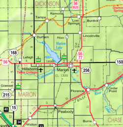
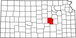
In 1854, the Kansas Territory was organized, then in 1861 Kansas became the 34th U.S. state. In 1855, Marion County was established within the Kansas Territory, which included the land for modern day Oursler. [3]

As early as 1875, city leaders of Marion held a meeting to consider a branch railroad from Florence. In 1878, Atchison, Topeka and Santa Fe Railway and parties from Marion County and McPherson County chartered the Marion and McPherson Railway Company. [4] In 1879, a branch line was built from Florence through Oursler to Marion then west to McPherson, in 1880 it was extended to Lyons, in 1881 it was extended to Ellinwood. [5] The line was leased and operated by the Atchison, Topeka and Santa Fe Railway.

Oursler was named for W.E.M. Oursler, who came to Kansas in 1870 and kept a post office on his place for several years. After the railroad was built from Florence to Marion on the southwest side of Oursler, a depot was built and mail was brought to the station early each day. In addition to the post office, there was a brick kiln and a small grocery store. On October 17, 1877, W.E.M. Oursler and his wife filed a plot for a small town named Oursler with a size of two blocks. [4]

20th century

The railroad from Florence to Oursler to Marion, was abandoned in 1968. [6]

21st century

Currently no buildings or landmarks exist in Oursler, thus it's considered a Ghost Town.

Geography

Oursler was located at coordinates 38°17′23″N, 96°58′52″W in the scenic Flint Hills and Great Plains of the state of Kansas. [1] It was on a triangular plot, located at the southwest corner of 150th Street and Union Road in Marion County, Kansas. It was bordered by the two roads and the railroad southwest of the corner. Its platted location was the NE 1/4 of the NW 1/4 of Section 27, Township 20, Range 4. [4] [7]

Related Research Articles

<span class="mw-page-title-main">Rice County, Kansas</span> County in Kansas, United States

Rice County is a county located in the U.S. state of Kansas. Its county seat and largest city is Lyons. As of the 2020 census, the county population was 9,427. The county was named in memory of Samuel Allen Rice, Brigadier-General, United States volunteers, killed April 30, 1864 at Jenkins Ferry, Arkansas.

<span class="mw-page-title-main">Morris County, Kansas</span> County in Kansas, United States

Morris County is a county located in the U.S. state of Kansas. Its county seat and largest city is Council Grove. As of the 2020 census, the county population was 5,386. The county was named for Thomas Morris, a U.S. Senator from Ohio and anti-slavery advocate.

<span class="mw-page-title-main">McPherson County, Kansas</span> County in Kansas, United States

McPherson County is a county located in the U.S. state of Kansas. Its county seat and largest city is McPherson. As of the 2020 census, the county population was 30,223. The county was named for James McPherson, a general in the American Civil War.

<span class="mw-page-title-main">Marion County, Kansas</span> County in Kansas, United States

Marion County is a county located in the U.S. state of Kansas. Its county seat is Marion and its most populous city is Hillsboro. As of the 2020 census, the county population was 11,823. The county was named in honor of Francis Marion, a brigadier general of the American Revolutionary War, known as the "Swamp Fox".

<span class="mw-page-title-main">Dickinson County, Kansas</span> County in Kansas, United States

Dickinson County is a county in Central Kansas. Its county seat and most populous city is Abilene. As of the 2020 census, the county population was 18,402. The county was named in honor of Daniel Dickinson, a U.S. Senator from New York that was a Kansas statehood advocate.

<span class="mw-page-title-main">Chase County, Kansas</span> County in Kansas, United States

Chase County is a county located in the U.S. state of Kansas. Its county seat and most populous city is Cottonwood Falls. As of the 2020 census, the county population was 2,572. The county was named for Salmon Chase, a U.S. Senator from Ohio that was a Kansas statehood advocate.

<span class="mw-page-title-main">Barton County, Kansas</span> County in Kansas, United States

Barton County is a county located in the U.S. state of Kansas. Its county seat and most populous city is Great Bend. As of the 2020 census, the county population was 25,493. The county is named in honor of Clara Barton, responsible for the founding of the American Red Cross, and the only county in Kansas to be named for a woman.

<span class="mw-page-title-main">Ellinwood, Kansas</span> City in Barton County, Kansas

Ellinwood is a city in the southeast corner of Barton County, Kansas, United States. As of the 2020 census, the population of the city was 2,011.

<span class="mw-page-title-main">Florence, Kansas</span> City in Marion County, Kansas

Florence is a city in Marion County, Kansas, United States. As of the 2020 census, the population of the city was 394. The city was named after the daughter of the third Governor of Kansas Samuel J. Crawford. It is located at the intersection of U.S. Route 50 and U.S. Route 77 highways.

<span class="mw-page-title-main">Hillsboro, Kansas</span> City in Marion County, Kansas

Hillsboro is a city in Marion County, Kansas, United States. As of the 2020 census, the population of the city was 2,732. The city was named after John Hill, who homesteaded in the area in 1871. Hillsboro is home of Tabor College.

<span class="mw-page-title-main">Lehigh, Kansas</span> City in Marion County, Kansas

Lehigh is a city in Marion County, Kansas, United States. As of the 2020 census, the population of the city was 161. It is located between Hillsboro and Canton on the north side of U.S. Route 56.

<span class="mw-page-title-main">Canton, Kansas</span> City in McPherson County, Kansas

Canton is a city in McPherson County, Kansas, United States. As of the 2020 census, the population of the city was 685. It is named after Canton, Ohio.

<span class="mw-page-title-main">Galva, Kansas</span> City in McPherson County, Kansas

Galva is a city in McPherson County, Kansas, United States. As of the 2020 census, the population of the city was 834.

<span class="mw-page-title-main">Chase, Kansas</span> City in Rice County, Kansas

Chase is a city in Rice County, Kansas, United States. As of the 2020 census, the population of the city was 396.

<span class="mw-page-title-main">Lyons, Kansas</span> City in Rice County, Kansas

Lyons is a city in and the county seat of Rice County, Kansas, United States. As of the 2020 census, the population of the city was 3,611.

<span class="mw-page-title-main">Mitchell, Kansas</span> Unincorporated community in Rice County, Kansas

Mitchell is an unincorporated community in Rice County, Kansas, United States. Located about 6 miles (9.7 km) east-northeast of the city of Lyons, it lies along local roads a fraction of a mile north of U.S. Route 56.

<span class="mw-page-title-main">Conway, Kansas</span> Unincorporated community in McPherson County, Kansas

Conway is an unincorporated community in southwestern Jackson Township, McPherson County, Kansas, United States. It lies along U.S. Route 56 and a Kansas and Oklahoma Railroad line, west of the city of McPherson.

<span class="mw-page-title-main">Canada, Kansas</span> Unincorporated community in Marion County, Kansas

Canada is an unincorporated community in Marion County, Kansas, United States. It is named for many Canadian immigrants coming to the area. It is located between Hillsboro and Marion about 0.5 miles south of the intersection of Nighthawk Road and U.S. Route 56 highway, southwest of the Hillsboro Cove of the Marion Reservoir.

<span class="mw-page-title-main">Waldeck, Kansas</span> Ghost town in Marion County, Kansas

Waldeck is a ghost town in Marion County, Kansas, United States. It is currently a ghost town that was located approximately 3.5 miles north of Lehigh next to a railroad. No buildings remain of this former community.

The Marion and McPherson Railroad was a short-line railroad in central Kansas.

References

  1. 1 2 3 4 5 6 "Oursler, Kansas", Geographic Names Information System , United States Geological Survey, United States Department of the Interior
  2. Blackmar, Frank Wilson (1912). Kansas: A Cyclopedia of State History, Volume 2. Standard Publishing Company. pp.  466.
  3. The History of Marion County and Courthouse
  4. 1 2 3 Marion County Kansas : Past and Present; Sondra Van Meter; MB Publishing House; LCCN 72-92041; 344 pages; 1972.
  5. Fourth Annual Report of the Board of Railroad Commissioners for the Year Ending December 1, 1886 in State of Kansas; Kansas Publishing House; 1886.
  6. Railway Abandonment 1968
  7. Atlas of Marion County Kansas - Centre Township (page 43); The Davy Map and Atlas Co; 87 pages; 1885.

Further reading

Historical
Maps