Waldeck, Kansas

Last updated

Waldeck, Kansas
Map of Marion Co, Ks, USA.png
USA Kansas location map.svg
Red pog.svg
Waldeck
Usa edcp location map.svg
Red pog.svg
Waldeck
Coordinates: 38°25′50″N97°20′06″W / 38.4305642°N 97.3350299°W / 38.4305642; -97.3350299 [1]
Country United States
State Kansas
County Marion
Township Lehigh
Founded1899
Platted 1899
Named for Waldeck
Elevation
[1]
1,555 ft (474 m)
Population
  Total0
Time zone UTC-6 (CST)
  Summer (DST) UTC-5 (CDT)
Area code 620
FIPS code 20-74540 [1]
GNIS ID 484810 [1]

Waldeck is a ghost town in Marion County, Kansas, United States. [1] It is currently a ghost town that was located approximately 3.5 miles north of Lehigh next to a railroad. [2] No buildings remain of this former community.

Contents

History

1915 Railroad Map of Marion County Stouffer's Railroad Map of Kansas 1915-1918 Marion County.png
1915 Railroad Map of Marion County

Early history

For many millennia, the Great Plains of North America was inhabited by nomadic Native Americans. From the 16th century to 18th century, the Kingdom of France claimed ownership of large parts of North America. In 1762, after the French and Indian War, France secretly ceded New France to Spain, per the Treaty of Fontainebleau.

19th century

In 1802, Spain returned most of the land to France. In 1803, most of the land for modern day Kansas was acquired by the United States from France as part of the 828,000 square mile Louisiana Purchase for 2.83 cents per acre.

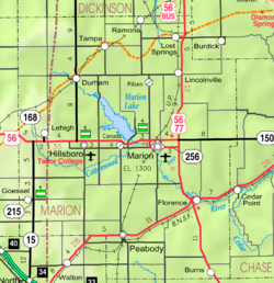
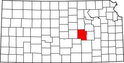
In 1854, the Kansas Territory was organized, then in 1861 Kansas became the 34th U.S. state. In 1855, Marion County was established within the Kansas Territory, which included the land for modern day Waldeck. [3]

From the 1820s to the 1870s, one of the most significant land routes in the United States was the Santa Fe Trail. The Santa Fe Trail was active across Marion County from 1821 to 1866. [4] Along the Santa Fe Trail, French Frank's Road Ranch and Cottonwood Holes (for watering) were original located on the land south of 245th Street. A Santa Fe Trail marker is located on the trail near Waldeck on 245th Street. [5]

Also, the Chisholm Trail crossed Marion County from 1867 to 1871. Amazingly, Waldeck was near the junction of the Santa Fe Trail and Chisolm Trail, possibly within 1 mile. [6]

In 1887, the Chicago, Kansas and Nebraska Railway built a main line from Herington through Waldeck to Pratt. [7] In 1888, this line was extended to Liberal. Later, it was extended to Tucumcari, New Mexico and El Paso, Texas. It foreclosed in 1891 and taken over by Chicago, Rock Island and Pacific Railway, which shut down in 1980 and reorganized as Oklahoma, Kansas and Texas Railroad, merged in 1988 with Missouri Pacific Railroad, and finally merged in 1997 with Union Pacific Railroad. Waldeck was a coal and water stop for the railroad during the steam era. To allow for continuous train passage for those not needing to stop, a siding in excess of one mile was built. The siding continues this function for east and westbound commerce to pass in the present day.

The construction of this line meant that the Chisholm Trail no longer needed to go the additional 40 miles to Abilene, Kansas (the former northern terminus). Among the last usable structures at Waldeck, cattle corrals were operational until the early 1950s, when diesel locomotives became dominant.

The town was most likely named by a Swiss Brethren after the former Waldeck sovereign principality in the German Empire. The land on which Waldeck would stand was sold to the Golden Belt Town Co in October 1887. The railroad was routed through the land and a depot was built, but the "boom spirit" of the 1880s turned downward, so the land was sold at a loss to the Kansas Town and Loan Company in the 1890s. A town with two block where platted on December 7, 1899. A small general store and school were located in the community, but the town didn't grow. [8]

21st century

Currently no buildings exist in Waldeck, thus it's considered a Ghost Town. There is a Santa Fe Trail marker nearby on 245th Street.

Geography

Waldeck was located at coordinates 38.4305642, -97.3350299 in the scenic Flint Hills and Great Plains of the state of Kansas. [1] It was on the north side of 245th Street between Bison Road and Chisholm Trail Road in Marion County, Kansas. It was bordered between 245th Street on the south side and the railroad on the north side. Its platted location was the NW 1/4 of Section 4, Township 19, Range 1. A Stock yard was located on the north side of the tracks. [8] [9] [10]

Related Research Articles

<span class="mw-page-title-main">Rice County, Kansas</span> County in Kansas, United States

Rice County is a county located in the U.S. state of Kansas. Its county seat and largest city is Lyons. As of the 2020 census, the county population was 9,427. The county was named in memory of Samuel Allen Rice, Brigadier-General, United States volunteers, killed April 30, 1864 at Jenkins Ferry, Arkansas.

<span class="mw-page-title-main">Morris County, Kansas</span> County in Kansas, United States

Morris County is a county located in the U.S. state of Kansas. Its county seat and largest city is Council Grove. As of the 2020 census, the county population was 5,386. The county was named for Thomas Morris, a U.S. Senator from Ohio and anti-slavery advocate.

<span class="mw-page-title-main">McPherson County, Kansas</span> County in Kansas, United States

McPherson County is a county located in the U.S. state of Kansas. Its county seat and largest city is McPherson. As of the 2020 census, the county population was 30,223. The county was named for James McPherson, a general in the American Civil War.

<span class="mw-page-title-main">Marion County, Kansas</span> County in Kansas, United States

Marion County is a county located in the U.S. state of Kansas. Its county seat is Marion and its most populous city is Hillsboro. As of the 2020 census, the county population was 11,823. The county was named in honor of Francis Marion, a brigadier general of the American Revolutionary War, known as the "Swamp Fox".

<span class="mw-page-title-main">Dickinson County, Kansas</span> County in Kansas, United States

Dickinson County is a county in Central Kansas. Its county seat and most populous city is Abilene. As of the 2020 census, the county population was 18,402. The county was named in honor of Daniel Dickinson, a U.S. Senator from New York that was a Kansas statehood advocate.

<span class="mw-page-title-main">Chase County, Kansas</span> County in Kansas, United States

Chase County is a county located in the U.S. state of Kansas. Its county seat and most populous city is Cottonwood Falls. As of the 2020 census, the county population was 2,572. The county was named for Salmon Chase, a U.S. Senator from Ohio that was a Kansas statehood advocate.

<span class="mw-page-title-main">Barton County, Kansas</span> County in Kansas, United States

Barton County is a county located in the U.S. state of Kansas. Its county seat and most populous city is Great Bend. As of the 2020 census, the county population was 25,493. The county is named in honor of Clara Barton, responsible for the founding of the American Red Cross, and the only county in Kansas to be named for a woman.

<span class="mw-page-title-main">Strong City, Kansas</span> City in Chase County, Kansas

Strong City is a city in Chase County, Kansas, United States. Originally known as Cottonwood Station, in 1881 it was renamed Strong City after William Barstow Strong, then vice-president and general manager, and later president of the Atchison, Topeka and Santa Fe Railway. As of the 2020 census, the population of the city was 386. It is located along U.S. Route 50 highway.

<span class="mw-page-title-main">Durham, Kansas</span> City in Marion County, Kansas

Durham is a city in Marion County, Kansas, United States. As of the 2020 census, the population of the city was 89. The city took its name from Durham cattle. It is located about 8.5 miles (14 km) north of Hillsboro on the west side of K-15 highway next to a railroad.

<span class="mw-page-title-main">Florence, Kansas</span> City in Marion County, Kansas

Florence is a city in Marion County, Kansas, United States. As of the 2020 census, the population of the city was 394. The city was named after the daughter of the third Governor of Kansas Samuel J. Crawford. It is located at the intersection of U.S. Route 50 and U.S. Route 77 highways.

<span class="mw-page-title-main">Lehigh, Kansas</span> City in Marion County, Kansas

Lehigh is a city in Marion County, Kansas, United States. As of the 2020 census, the population of the city was 161. It is located between Hillsboro and Canton on the north side of U.S. Route 56.

<span class="mw-page-title-main">Lost Springs, Kansas</span> City in Marion County, Kansas

Lost Springs is a city in Marion County, Kansas, United States. As of the 2020 census, the population of the city was 55. The city was named for a nearby lost spring that was a camping spot along the 19th century Santa Fe Trail. It is located south of Herington, about 0.6 miles west of the intersection of U.S. Route 77 highway and 340th Street next to the Union Pacific Railroad.

<span class="mw-page-title-main">Marion, Kansas</span> City in Marion County, Kansas

Marion is a city in, and the county seat of, Marion County, Kansas, United States. As of the 2020 census, the population of the city was 1,922. The city was named in honor of Francis Marion, a brigadier general of the American Revolutionary War, known as the "Swamp Fox".

<span class="mw-page-title-main">Peabody, Kansas</span> City in Marion County, Kansas

Peabody is a city in Marion County, Kansas, United States. As of the 2020 census, the population of the city was 937. The city was named after F.H. Peabody of Boston, former vice-president of the Atchison, Topeka and Santa Fe Railway. Peabody is well known in the region for its Independence Day Celebration on July 4, and its historic 1880s downtown main street. It is located between Newton and Florence along U.S. Route 50 highway.

<span class="mw-page-title-main">Tampa, Kansas</span> City in Marion County, Kansas

Tampa is a city in Marion County, Kansas, United States. As of the 2020 census the population of the city was 105. It is located between Durham and Ramona and is next to a railroad.

<span class="mw-page-title-main">Canton, Kansas</span> City in McPherson County, Kansas

Canton is a city in McPherson County, Kansas, United States. As of the 2020 census, the population of the city was 685. It is named after Canton, Ohio.

<span class="mw-page-title-main">Galva, Kansas</span> City in McPherson County, Kansas

Galva is a city in McPherson County, Kansas, United States. As of the 2020 census, the population of the city was 834.

<span class="mw-page-title-main">Burdick, Kansas</span> Unincorporated community in Morris County, Kansas

Burdick is an unincorporated community in Morris County, Kansas, United States. It was named after Ms. Burdick, the sweetheart of a Santa Fe Railroad official in 1887. As of the 2020 census, the population of the community and nearby areas was 62. It is located southeast of Herington, about 5.6 miles (9.0 km) east of the intersection of U.S. Route 77 highway and 340th Street, or about 6.5 miles (10.5 km) east of Lost Springs.

<span class="mw-page-title-main">Canada, Kansas</span> Unincorporated community in Marion County, Kansas

Canada is an unincorporated community in Marion County, Kansas, United States. It is named for many Canadian immigrants coming to the area. It is located between Hillsboro and Marion about 0.5 miles south of the intersection of Nighthawk Road and U.S. Route 56 highway, southwest of the Hillsboro Cove of the Marion Reservoir.

<span class="mw-page-title-main">Oursler, Kansas</span> Ghost town in Marion County, Kansas

Oursler is a ghost town in Marion County, Kansas, United States. It is currently a ghost town that was located approximately 3.5 miles southeast of Marion next to a former railroad. No buildings remain of this former community.

References

  1. 1 2 3 4 5 6 "Waldeck, Kansas", Geographic Names Information System , United States Geological Survey, United States Department of the Interior
  2. Blackmar, Frank Wilson (1912). Kansas: A Cyclopedia of State History, Volume 2. Standard Publishing Company. pp.  466.
  3. The History of Marion County and Courthouse
  4. History of the Cottonwood Crossing Chapter, Santa Fe Trail Association.
  5. 1997 Survey of DAR Markers in Kansas
  6. Detailed map of the Chisolm Trail through Kansas; Kansas Historical Society.
  7. "Rock Island Rail History". Archived from the original on June 19, 2011. Retrieved May 13, 2014.
  8. 1 2 Marion County Kansas : Past and Present; Sondra Van Meter; MB Publishing House; LCCN 72-92041; 344 pages; 1972.
  9. Atlas of Marion County Kansas - Lehigh Township (page 25); Geo A. Ogle & Co; 103 pages; 1902.
  10. Atlas of Marion County Kansas - Plat of Waldeck (page 32); Geo A. Ogle & Co; 103 pages; 1902.

Further reading

Historical
Maps