Sumner County is a county located in the U.S. state of Kansas. Its county seat is Wellington. As of the 2020 census, the population was 22,382. The county is named after Charles Sumner, a U.S. Senator from Massachusetts who was a leader of Reconstruction politics.

Morris County is a county located in the U.S. state of Kansas. Its county seat and largest city is Council Grove. As of the 2020 census, the county population was 5,386. The county was named for Thomas Morris, a U.S. Senator from Ohio and anti-slavery advocate.

Marion County is a county located in the U.S. state of Kansas. Its county seat is Marion and its most populous city is Hillsboro. As of the 2020 census, the county population was 11,823. The county was named in honor of Francis Marion, a brigadier general of the American Revolutionary War, known as the "Swamp Fox".

Dickinson County is a county in Central Kansas. Its county seat and most populous city is Abilene. As of the 2020 census, the county population was 18,402. The county was named in honor of Daniel Dickinson, a U.S. Senator from New York that was a Kansas statehood advocate.

Chase County is a county located in the U.S. state of Kansas. Its county seat and most populous city is Cottonwood Falls. As of the 2020 census, the county population was 2,572. The county was named for Salmon Chase, a U.S. Senator from Ohio that was a Kansas statehood advocate.
Butler County is a county in the U.S. state of Kansas and is the largest county in the state by total area. Its county seat is El Dorado and its most populous city is Andover. As of the 2020 census, the county population was 67,380. The county was named for Andrew Butler, a U.S. Senator from South Carolina who coauthored the Kansas–Nebraska Act.

Burns is a city in Marion County, Kansas, United States. The city name came from a nearby train station, which was named prior to the city being incorporated. As of the 2020 census, the population of the city was 234. It is located between El Dorado and Florence along the west side of U.S. Route 77 highway. The south edge of the city is the border of Marion and Butler counties.

Durham is a city in Marion County, Kansas, United States. As of the 2020 census, the population of the city was 89. The city took its name from Durham cattle. It is located about 8.5 miles north of Hillsboro on the west side of K-15 highway next to a railroad.

Florence is a city in Marion County, Kansas, United States. The city was named after the daughter of the third Governor of Kansas Samuel J. Crawford. As of the 2020 census, the population of the city was 394. It is located at the intersection of U.S. Route 50 and U.S. Route 77 highways.

Lincolnville is a city in Marion County, Kansas, United States. As of the 2020 census, the population of the city was 168. It is located northeast of Marion, west of the intersection of U.S. Route 77 highway and 290th Street next to the Union Pacific Railroad.

Lost Springs is a city in Marion County, Kansas, United States. It was named for the old lost spring near the city. As of the 2020 census, the population of the city was 55. It is located south of Herington, about 0.6 miles west of the intersection of U.S. Route 77 highway and 340th Street next to the Union Pacific Railroad.
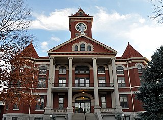
Marion is a city in, and the county seat of, Marion County, Kansas, United States. It was named in honor of Francis Marion, a brigadier general of the American Revolutionary War, known as the "Swamp Fox". As of the 2020 census, the population of the city was 1,922.

Peabody is a city in Marion County, Kansas, United States. It is named after F.H. Peabody of Boston, former vice-president of the Atchison, Topeka and Santa Fe Railway. Peabody is well known in the region for its Independence Day Celebration on July 4, and its historic 1880s downtown main street. As of the 2020 census, the population of the city was 937. It is located between Newton and Florence along U.S. Route 50 highway.

Ramona is a city in Marion County, Kansas, United States. As of the 2020 census, the population of the city was 78. It is located southwest of Herington next to a railroad.

Walton Township is a township in Harvey County, Kansas, United States. As of the 2000 census, its population was 552.

Aulne is an unincorporated community in Marion County, Kansas, United States. The Aulne name was suggested by officials of the railroad when it was built through Aulne during the 19th century. It is located southwest of Marion at the intersection of Pawnee Road and 140th Street next to the Union Pacific Railroad.

Catlin Township is a township in Marion County, Kansas, United States. As of the 2010 census, the township population was 187, including a fraction of the city of Peabody.

Milton Township is a township in Marion County, Kansas, United States. As of the 2010 census, the township population was 310, including the city of Burns.

Doyle Township is a township in Marion County, Kansas, United States. As of the 2010 census, the township population was 60, not including the city of Florence. Doyle was first settled by Euro-Americans in 1858.
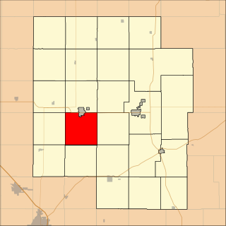
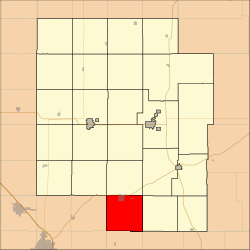
Liberty Township is a township in Marion County, Kansas, United States. As of the 2010 census, the township population was 320, not including the city of Hillsboro.