Eileanan Chearabhaigh

Last updated

Eileanan Chearabhaigh
Scottish Gaelic nameEileanan Chearabhaigh
Eileanan Chearabhaigh.jpg
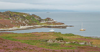
The islands of Eileanan Chearabhaigh at centre, with mainland Benbecula in the foreground and the northern tip of Wiay beyond
Location
Outer Hebrides UK relief location map.jpg
Red pog.svg
Eileanan Chearabhaigh
Eileanan Chearbhaigh shown within the Outer Hebrides
OS grid reference NF866476
Coordinates 57°25′N7°13′W / 57.41°N 7.22°W / 57.41; -7.22
Physical geography
Island group Uist
Area49 ha (120 acres) [1]
Highest elevationc. 23 m (75 ft) [2]
Administration
Sovereign state United Kingdom
Country Scotland
Council area Comhairle nan Eilean Siar
Lymphad3.svg

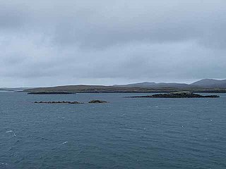
Eileanan Chearabhaigh is a collection of small uninhabited tidal islands off the south east coast of Benbecula in the Outer Hebrides of Scotland. The English language name Keiravagh Islands is sometimes used. [3]

Contents

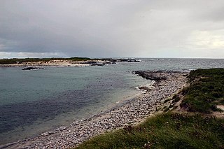
Bounded by the tidal waters of Loch Chearabhaigh to the north and Loch a' Laip to the south, the land area of the group defies a simple description. At low tide the islands form a peninsula with a total area of about 50 hectares (120 acres), which is connected to Benbecula by drying sands. At high tide the connection to Benbecula is lost and a number of small islets stretching for over two kilometres (1+14 mi) from east to west appear, the largest of which is about 31 hectares (77 acres) in extent. [Note 1] None of these individual islets are named by the Ordnance Survey. Argyll Yacht Charters supply a table of islands statistics that list the "Kiervagh islands" as being 49 hectares (120 acres) in extent, although the method of measurement is not explicit. [1]

The uninhabited island of Wiay lies to the south and fish farming is undertaken in the productive waters of Loch a' Laip and Loch Chearabhaigh. [3] [4] Loch a' Laip also provides shelter for visiting water craft but the area is strewn with rocks and skerries. There is a pier on Benbecula served by a track at the western end of Eileanan Chearabhaigh and another to the south at Eilean na Cille, although their use without local knowledge is not advised. [2] [5]

See also

Nearby islands with a similarly complex geography:

Notes

  1. Haswell-Smith (2004) lists all the islands of Scotland that are greater in size than 40 hectares (99 acres). The definition he uses is "an Island is a piece of land or group of pieces of land which is entirely surrounded by water at Lowest Astronomical Tide and to which there is no permanent means of dry access". This therefore excludes Eileanan Chearabhaigh at low tide and also its largest constituent island at high tide (as it is less than 40 ha in extent).

Footnotes

  1. 1 2 Rick Livingstone’s Tables of the Islands of Scotland (pdf) Argyll Yacht Charters. Retrieved 12 Dec 2011.
  2. 1 2 Ordnance Survey. OS Maps Online (Map). 1:25,000. Leisure.
  3. 1 2 Haswell-Smith (2004) p. 249
  4. "Portfolio Management" page 34. Crown Estate. Retrieved 16 April 2011.
  5. Haswell-Smith (2004) p. 250

Related Research Articles

Isay

Isay is an uninhabited island in the Inner Hebrides of the west coast of Scotland. It lies in Loch Dunvegan, 1 kilometre (1,100 yd) off the northwest coast of the Isle of Skye. Two smaller isles of Mingay and Clett lie nearby. The name originated from the Old Norse ise-øy meaning porpoise island. The island of Lampay is due south. The area of Isay is 60 hectares.

Eilean Dubh Mòr

Eilean Dubh Mòr is an uninhabited island in the Inner Hebrides of Scotland. It lies at the mouth of the Firth of Lorn, between the islands of Lunga and Garbh Eileach. The area of the island has been measured variously—at 50 hectares by Livingstone and 65 hectares by Haswell-Smith, the latter including the nearby islet of Eilean Dubh Beag, which is joined to Eilean Dubh Mòr at low tide.

Wiay, Outer Hebrides

Wiay is an uninhabited island in the Outer Hebrides.

Muckle Green Holm Uninhabited island in the North Isles of the Orkney archipelago in Scotland

Muckle Green Holm is an uninhabited island in the North Isles of the Orkney archipelago in Scotland. It is roughly 28 hectares (0.11 sq mi) in extent and rises to 28 metres (92 ft) above sea level, the summit having a triangulation pillar.

Hermetray is an uninhabited island off North Uist, in the Outer Hebrides of Scotland.

Nave Island

Nave Island lies to the north of Islay in the Inner Hebrides near the mouth of Loch Gruinart. It is uninhabited.

Sibhinis Tidal island of the Monach Islands, lying between Ceann Iar and Ceann Ear

Sibhinis, Siobhanais or Shivinish. is one of the Monach Islands, lying between Ceann Iar and Ceann Ear. It is tidal, and connected at low tide to Ceann Iar by Fadhail Shibhinis, and to Ceann Ear by Faodhail Chinn Ear. It is 16 metres at its highest point. It is said that it was at one time possible to walk all the way to Baleshare, and on to North Uist, five miles (8 km) away at low tide. In the 16th century, a large tidal wave was said to have washed this away.

Ceallasaigh Mòr is a low-lying island in Loch Maddy off North Uist in the Outer Hebrides of Scotland. This an area of shallow lagoons filled and drained by the tides each day. Ceallasaigh Beag lies to the south and these two islets are connected by a narrow strip of sand at low tide. Ceallasaigh Mòr may also join mainland North Uist near Bràigh Cheallasaigh at some stages of the tide.

Stromay is a tidal island off North Uist in the Sound of Harris, Scotland.

Orosay

Orosay is a small uninhabited tidal island in the Sound of Barra lying at the north end of Traigh Mhòr, the "big beach" on the north east coast of Barra. It is one of ten islands in the Sound of Barra, a Site of Community Importance for conservation in the Outer Hebrides of Scotland. It is about 30 hectares in extent and the highest point is 38 metres (125 ft).

Fraoch-Eilean

Fraoch-eilean is a small island with an uncertain population north of Benbecula in the Outer Hebrides of Scotland. It is about 55 hectares in extent and the highest point is 11 metres (36 ft). Its name derives from the Gaelic for "heather island".

Eilean Hoan is an island in Loch Eriboll in Sutherland on the north coast of Scotland. It is about 28 hectares in extent and the highest point is 25 metres (82 ft) above sea level. Its name is of Gaelic and Old Norse derivation and means "haven island".

Eilean Tigh

Eilean Tigh is a tidal island in the Sound of Raasay of Scotland, that lies between Rona and Raasay.

Ceallasaigh Beag

Ceallasaigh Beag is a low-lying island in Loch Maddy off North Uist in the Outer Hebrides of Scotland. This an area of shallow lagoons filled and drained by the tides each day. Ceallasaigh Mòr lies to the south and these two islets are connected by a narrow strip of sand during some low tides.

Flodday, Loch Maddy

Flodday is an uninhabited island in Loch Maddy, North Uist in the Outer Hebrides of Scotland.

References

Coordinates: 57°24′43″N7°12′47″W / 57.412°N 7.213°W / 57.412; -7.213