Elsie, Oregon

Last updated

Elsie, Oregon
Elderberry Inn Elsie Oregon.JPG
Elderberry Inn
USA Oregon location map.svg
Red pog.svg
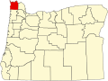
Elsie
Location within the state of Oregon
Usa edcp location map.svg
Red pog.svg
Elsie
Elsie (the United States)
Coordinates: 45°51′56″N123°35′41″W / 45.86556°N 123.59472°W / 45.86556; -123.59472
Country United States
State Oregon
County Clatsop
Elevation
[1]
453 ft (138 m)
Time zone UTC-8 (Pacific (PST))
  Summer (DST) UTC-7 (PDT)
ZIP code
97138
Area code(s) 503 and 971
GNIS feature ID1136261 [1]

Elsie is an unincorporated community in Clatsop County, Oregon, United States. It is located in the Northern Oregon Coast Range, west of the junction of Oregon Route 103 and U.S. Route 26 where the roads cross the Nehalem River.

Elsie was named after Elsie Foster, who was a relative of George Gragg, the first postmaster. [2] Elsie post office was established in 1892 and closed in 1943. [2]

Camp 18 is a restaurant and logging museum in Elsie. [3] The restaurant is built in the style of a log cabin, using local timber. [3] The building includes an 85-foot ridge pole and front doors that weigh 500 pounds each. [3]

Related Research Articles

<span class="mw-page-title-main">Dayton, Oregon</span> City in Oregon, United States

Dayton is a city in Yamhill County, Oregon, United States. The population was 2,678 at the 2020 census.

<span class="mw-page-title-main">Zigzag, Oregon</span> Unincorporated community in the state of Oregon, United States

Zigzag is an unincorporated community in Clackamas County, Oregon, United States. It is located within the Mount Hood Corridor, between Rhododendron and Welches on U.S. Route 26. The community is part of a local type of government called a village as one of the communities making up the Villages at Mount Hood, which stretches from the border of Sandy to Government Camp.

Idiotville is a ghost town in Tillamook County, Oregon, United States, near the mouth of Idiot Creek on the Wilson River, on the route of Oregon Route 6. Idiotville's elevation is 1,200 feet.

Mist is an unincorporated community in Columbia County, Oregon, United States. Formerly called Riverside, the place was renamed in 1888 for the atmospheric conditions of the Nehalem Valley. The first land claims in the area had been made circa 1870. The original Riverside post office was closed in 1975.

<span class="mw-page-title-main">Twin Rocks, Oregon</span> Unincorporated community in the state of Oregon, United States

Twin Rocks is an unincorporated community in Tillamook County, Oregon, United States, on the Oregon Coast. Twin Rocks, founded as a summer resort community, was named for two offshore rocks, 100 feet (30 m) high, in the Pacific Ocean. Twin Rocks post office was established in 1914, with William E. Dunsmoor as the first postmaster. The post office closed in 1954.

<span class="mw-page-title-main">Agness, Oregon</span> Unincorporated community in the state of Oregon, United States

Agness is an unincorporated community in Curry County, Oregon, United States. It is near the confluence of two Wild and Scenic rivers—the Lower Rogue and the Illinois. Agness post office was established October 16, 1897. It was named after Agnes, the daughter of the first postmaster, and subsequently misspelled. The Agness area is popular for fishing and hiking. Agness is in the Rogue River–Siskiyou National Forest and was threatened by the Biscuit Fire in 2002.

<span class="mw-page-title-main">Algoma, Oregon</span> Unincorporated community in the state of Oregon, United States

Algoma is an unincorporated community on the east shore of Upper Klamath Lake, in Klamath County, Oregon, United States. It is about 8 miles (13 km) north of the city of Klamath Falls on U.S. Route 97. Algoma was named for the Algoma Lumber Company.

<span class="mw-page-title-main">Prospect, Oregon</span> Unincorporated community in the state of Oregon, United States

Prospect is an unincorporated community and census-designated place (CDP) in Jackson County, in the U.S. state of Oregon. It lies along Oregon Route 62 on the Rogue River, in the Rogue River – Siskiyou National Forest. As of the 2010 census it had a population of 455.

<span class="mw-page-title-main">Jewell, Oregon</span> Unincorporated community in the state of Oregon, United States

Jewell is an unincorporated community in Clatsop County, Oregon, United States. The logging community is located at the junction of Oregon Route 103 and Oregon Route 202, near the Nehalem River.

Austin is an unincorporated community, considered a ghost town, in Grant County, Oregon, United States. It is located north of Oregon Route 7, near the Middle Fork John Day River in the Malheur National Forest.

<span class="mw-page-title-main">Finn Rock, Oregon</span> Unincorporated community in the state of Oregon, United States

Finn Rock is an unincorporated community in Lane County, Oregon, United States. It is located on Oregon Route 126 and the McKenzie River, between the communities of Nimrod and Blue River, in the Willamette National Forest.

<span class="mw-page-title-main">Apiary, Oregon</span> Unincorporated community in the state of Oregon, United States

Apiary is an unincorporated community in Columbia County, Oregon, United States, that takes its name from a post office established by David M. Dorsey. The post office operated from August 28, 1889, until March 24, 1924. It is reported that Dorsey was a beekeeper, which provided the source of the name for the Post Office and thus the community.

<span class="mw-page-title-main">Wendling, Oregon</span> Unincorporated community in the state of Oregon, United States

Wendling is an unincorporated community in Lane County, Oregon, United States, located northeast of Marcola. Wendling's post office operated from 1899 to 1952. It was named for George X. Wendling, a local lumberman. Wendling was created as a company town for the Booth-Kelly Lumber Company.

<span class="mw-page-title-main">Camp Abbot</span>

Camp Abbot was a military training center in the northwest United States, located in central Oregon south of Bend. Active for less than sixteen months, the U.S. Army camp was used to train combat engineers during World War II and was named for Henry Larcom Abbot.

<span class="mw-page-title-main">Glenwood, Washington County, Oregon</span> Unincorporated community in the state of Oregon, United States

Glenwood is an unincorporated community in Washington County, Oregon, United States, northwest of Forest Grove on Oregon Route 6.

<span class="mw-page-title-main">Union Creek Historic District</span> Historic district in Oregon, United States

Union Creek Historic District near the upper Rogue River in Union Creek, Oregon, is listed on the U.S. National Register of Historic Places for rustic structures built by the Civilian Conservation Corps (CCC) in the 1930s. The site lies along Oregon Route 62 and the upper Rogue River, about 12 miles (19 km) north of Prospect and about 20 miles (32 km) west of Crater Lake.

Woodson is an unincorporated community in Columbia County, Oregon, United States. It is located on U.S. Route 30 seven miles west of Clatskanie and three miles east of Westport, on Westport Slough, a tributary of the Columbia River. In December 2007, the debris overflow from the flooding of Eilersten Creek caused evacuations and mud cover on Woodson Road north of the highway.

Clifton is an unincorporated community in Clatsop County, Oregon, United States. It is located north of U.S. Route 30, about nine miles northwest of Westport on the south bank of the Columbia River. It is on Clifton Channel across from Tenasillahe Island.

Black Rock is an unincorporated community and former logging camp in Polk County, Oregon, United States. It is located about three miles west of Falls City, in the Central Oregon Coast Range on the Little Luckiamute River.

Shevlin was an unincorporated community in Deschutes and Klamath counties in the U.S. state of Oregon. It consisted of a collection of logging camp buildings that were moved from place to place on rail cars as logging progressed. The loggers worked for the Shevlin–Hixson Company.

References

  1. 1 2 U.S. Geological Survey Geographic Names Information System: Elsie, Oregon
  2. 1 2 McArthur, Lewis A.; Lewis L. McArthur (2003) [1928]. Oregon Geographic Names (7th ed.). Portland, Oregon: Oregon Historical Society Press. p. 328. ISBN   0-87595-277-1.
  3. 1 2 3 Camp 18 Logging Museum & Restaurant History

Commons-logo.svg Media related to Elsie, Oregon at Wikimedia Commons