Related Research Articles

The Necanicum River is a river on the Pacific coast of northwest Oregon in the United States, approximately 21 miles (34 km) long. It drains a timber-producing area of the Northern Oregon Coast Range northwest of Portland. It forms the first estuary south of the mouth of the Columbia River along the Oregon Coast, reaching the Pacific Ocean at Seaside in Clatsop County.
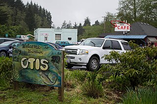
Otis is an unincorporated community in Lincoln County, Oregon, United States, a half mile north of Otis Junction on Oregon Route 18. It is near the Salmon River.
Ash is an unincorporated community in Douglas County, Oregon, United States, south of Loon Lake in the Southern Oregon Coast Range. The community is also referred to as Ash Valley.
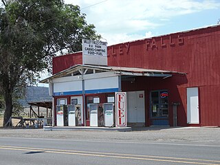
Valley Falls is a small unincorporated community in Lake County, Oregon, United States. The settled area is located at the junction of U.S. Route 395 and Oregon Route 31. The community is named for a small falls on the Chewaucan River just north of the occupied site. East of Valley Falls, the cliff face of Abert Rim overlooks the community.
Goldson is an unincorporated community in Lane County, Oregon, United States on Oregon Route 36 near Bear Creek, about 3.5 miles (5.6 km) from Cheshire. Goldson post office was established in 1891 and named for the first postmaster, J. M. Goldson. It ran until 1934. The community's elevation is 404 feet (123 m).
Cold Springs is an unincorporated community in Umatilla County, Oregon, United States, south of the Columbia River in the Hermiston area. Cold Springs Junction is a populated place and highway junction about 4 miles (6 km) northeast of Cold Springs at the junction of Oregon Route 37 and U.S. Route 730.

Horton is an unincorporated community in Lane County, Oregon, United States. It is about three miles northeast of Blachly, in the Lake Creek valley of the Central Oregon Coast Range.

Milo is an unincorporated community in Douglas County, Oregon, United States, about 17 miles (27 km) east of Canyonville on the South Umpqua River.
Starkey is an unincorporated community in Union County, Oregon, United States, about 26 miles southwest of La Grande. It is about two miles south of Oregon Route 244 in the Blue Mountains.
Wonder is an unincorporated community in Josephine County, Oregon, United States, on U.S. Route 199 about 13 miles west of Grants Pass and 8 miles east of Selma. It is within the Rogue River – Siskiyou National Forest.
Carus is an unincorporated community in Clackamas County, Oregon, United States. It is located about seven miles south of Oregon City, on Oregon Route 213.
Hamlet is an unincorporated community in Clatsop County, Oregon, United States. It is located approximately six miles southeast of Necanicum, in the Northern Oregon Coast Range near the confluence of the North Fork Nehalem River and the Little North Fork Nehalem River. It is surrounded by units of the Clatsop State Forest.
Holland is an unincorporated community in Josephine County, Oregon, United States. It is about eight miles southeast of Cave Junction, in the Illinois Valley south of Oregon Route 46.
Dixie is an unincorporated historic community in Washington County, Oregon, United States. Dixie post office was established five or six miles southwest of Scappoose in 1887, with John Dix as the first postmaster. The office was named for the Dix family and not for the U.S. South. The office closed in 1924, but when real estate was being sold in the area in 1933, a name for the locality was needed for marketing reasons. When a vote was held at a community picnic circa 1936 or 1937, 80 of the attendees chose the name "Dixie" to commemorate the former post office and its postmaster.
Weatherby is an unincorporated community in Baker County, Oregon, United States. It is about 9 miles (14 km) southeast of Durkee on Interstate 84/U.S. Route 30, near the Burnt River.
Brownsboro is an unincorporated community in Jackson County, Oregon, United States, on Oregon Route 140 about 4 miles (6 km) east of Eagle Point.
Fort Hill is an unincorporated community in Polk and Yamhill counties in Oregon, United States. It is located about a mile east of Spirit Mountain Casino on Oregon Route 22 near the South Yamhill River. For statistical purposes, the United States Census Bureau has defined Fort Hill as a census-designated place (CDP). The census definition of the area may not precisely correspond to local understanding of the area with the same name. The hill of the same name, located just east of Valley Junction, was the site of a blockhouse built by settlers in 1855–1856. The blockhouse became part of Fort Yamhill, and was later moved to Grand Ronde Agency and is now located in Dayton.
Suver is an unincorporated community in Polk County, Oregon, United States. It is located about 10 miles north of Corvallis and about 8 miles south of Monmouth, 1 mile east of Oregon Route 99W.
Faubion is an unincorporated community in Clackamas County, Oregon, United States. It is located about 2 miles northwest of Rhododendron, in the Mount Hood Corridor on a loop road off U.S. Route 26 near the Zigzag River.
Harney is an unincorporated community in Harney County, in the U.S. state of Oregon. It lies north of U.S. Route 20 between Burns and Buchanan near the site of historic Fort Harney. The community, county, and nearby geographic features such as Harney Lake are named for William S. Harney, a military officer popular in the Pacific Northwest in the mid-19th century.
References
- 1 2 "Necanicum (historical)". Geographic Names Information System . United States Geological Survey, United States Department of the Interior. May 22, 1986. Retrieved December 18, 2010.
- ↑ Oregon Atlas & Gazetteer (7th ed.). Yarmouth, Maine: DeLorme. 2008. p. 20. ISBN 0-89933-347-8.
- ↑ "Necanicum Junction". Geographic Names Information System . United States Geological Survey, United States Department of the Interior. May 22, 1986. Retrieved December 18, 2010.
- 1 2 3 4 5 6 7 McArthur, Lewis A.; McArthur, Lewis L. (2003) [1928]. Oregon Geographic Names (7th ed.). Portland, Oregon: Oregon Historical Society Press. pp. 693–694. ISBN 978-0875952772.
- 1 2 Friedman, Ralph (1990). In Search of Western Oregon (2nd ed.). Caldwell, Idaho: The Caxton Printers, Ltd. ISBN 0-87004-332-3.
Municipalities and communities of Clatsop County, Oregon, United States | ||
|---|---|---|
| Cities |  | |
| CDPs | ||
| Other communities | ||
45°54′24″N123°47′05″W / 45.906777°N 123.784855°W
| | This Clatsop County, Oregon state location article is a stub. You can help Wikipedia by expanding it. |