Related Research Articles

Clatsop County is one of the 36 counties in the U.S. state of Oregon. As of the 2010 census, the population was 37,039. The county seat is Astoria. The county is named for the Clatsop tribe of Native Americans, who lived along the coast of the Pacific Ocean prior to European settlement.

Jewell Junction, better known as Jewell, is a city in Hamilton County, Iowa, United States. The population was 1,216 at the time of the 2020 census.

The North Coast of California is a region in Northern California that lies on the Pacific coast between San Francisco Bay and the Oregon border. It commonly includes Mendocino, Humboldt, and Del Norte counties and sometimes includes two counties from the San Francisco Bay area, Marin and Sonoma.
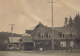
Jewell is an unincorporated community in Clatsop County, Oregon, United States. The logging community is located at the junction of Oregon Route 103 and Oregon Route 202, near the Nehalem River.

Wren is an unincorporated community in Benton County, Oregon, United States. It is located at the junction of U.S. Route 20 and Oregon Route 223 on the Marys River.
High Pass is a mountain pass in the foothills of the Coast Range mountains in Lane County, Oregon, United States. High Pass Road connects the unincorporated community of Horton, on the west side of the pass, with Cheshire, Monroe, Junction City, and the other low-lying farm towns to the east. Oregon Route 36 provides an alternate route through the foothills over the nearby Low Pass.

Pedee is an unincorporated community in Polk County, Oregon, United States. Pedee is at the intersection of Oregon Route 223 and Maple Grove Road. It is part of the Salem Metropolitan Statistical Area.
Valley Junction is an unincorporated community in Polk County, Oregon, United States. It is located at the junction of Oregon Route 18 and Oregon Route 22, on the South Yamhill River east of Grand Ronde. A now-abandoned section of the Willamina and Grand Ronde Railway short line passed through Valley Junction. The Fort Yamhill State Heritage Area and Spirit Mountain Casino are nearby.
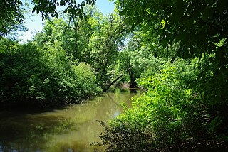
Dairy Creek is a 10.55-mile (16.98 km) tributary of the Tualatin River in the U.S. state of Oregon. It begins at the confluence of its east and west forks near the unincorporated community of Schefflin and meanders southeast across the Tualatin Valley to the Tualatin River near Hillsboro, in Washington County. East Fork Dairy Creek begins at 45.788446°N 123.041498°W in Columbia County, slightly north of its border with Washington County, and flows generally south for 22 miles (35 km). West Fork Dairy Creek, also about 22 miles (35 km) long, forms at 45.7553899°N 123.178168°W, near the unincorporated community of Tophill, and flows generally southeast. Before railroads displaced river boats on the Tualatin, some steamships also worked the lower section of Dairy Creek, with plans to go as far up stream as Centerville.
Otis Junction is an unincorporated community in Lincoln County, Oregon, United States, at the junction of the former route of U.S. Route 101 and Oregon Route 18, a half mile south of Otis. It is a mile and a half east of where OR 18 intersects with the modern route of U.S. 101.

Dolph is an unincorporated community in Tillamook County, Oregon, United States, near the Yamhill County line. It lies at the junction of Oregon Route 22 and Oregon Route 130 between Grande Ronde and Hebo, on the Little Nestucca River. It is within the Siuslaw National Forest in the Northern Oregon Coast Range.

Brunks Corner is an unincorporated community in Polk County, Oregon, United States, at the junction of Oregon Route 22 and Oak Grove Road, near the terminus of Oregon Route 51.

Hilgard is an unincorporated community in Union County, Oregon, United States, at the junction of Oregon Route 244 with Interstate 84/U.S. Route 30, near the Grande Ronde River. It is also the site of a junction (wye) of the Union Pacific Railroad. Hilgard Junction State Recreation Area is across the river from the community.

Greenville is an unincorporated historic community in Washington County, Oregon, United States. It is located approximately two miles south of Banks on Oregon Route 47.
Necanicum is an unincorporated community in Clatsop County, Oregon, United States. It is located approximately 13 miles southeast of Seaside on U.S. Route 26 in the Northern Oregon Coast Range, next to the Necanicum River. Necanicum Junction is about a mile east of the site of the former post office, at the intersection of U.S. 26 and Oregon Route 53. It is served by the Seaside post office.
Saint Joseph is an unincorporated community in Yamhill County, Oregon, United States. It is located about two miles west of Lafayette near Oregon Route 99W. The area is sometimes known as "St. Joe".
Holland is an unincorporated community in Josephine County, Oregon, United States. It is about eight miles southeast of Cave Junction, in the Illinois Valley south of Oregon Route 46.
Pleasant Valley is an unincorporated community in Tillamook County, Oregon, United States. It is located about seven miles south of Tillamook, on U.S. Route 101.
Fort Hill is an unincorporated community in Polk and Yamhill counties in Oregon, United States. It is located about a mile east of Spirit Mountain Casino on Oregon Route 22 near the South Yamhill River. For statistical purposes, the United States Census Bureau has defined Fort Hill as a census-designated place (CDP). The census definition of the area may not precisely correspond to local understanding of the area with the same name. The hill of the same name, located just east of Valley Junction, was the site of a blockhouse built by settlers in 1855–1856. The blockhouse became part of Fort Yamhill, and was later moved to Grand Ronde Agency and is now located in Dayton.
Suver is an unincorporated community in Polk County, Oregon, United States. It is located about 10 miles north of Corvallis and about 8 miles south of Monmouth, 1 mile east of Oregon Route 99W.
References
- ↑ "Jewell Junction". Geographic Names Information System . United States Geological Survey. November 28, 1980. Retrieved July 13, 2011.
- ↑ Oregon Atlas & Gazetteer (7th ed.). Yarmouth, Maine: DeLorme. 2008. p. 21. ISBN 0-89933-347-8.
Coordinates: 45°51′32″N123°33′15″W / 45.859000°N 123.554292°W
Municipalities and communities of Clatsop County, Oregon, United States | ||
|---|---|---|
| Cities |  | |
| CDPs | ||
| Other communities | ||
| | This Clatsop County, Oregon state location article is a stub. You can help Wikipedia by expanding it. |