Svensen, Oregon | |
|---|---|
 Fire station | |
 Svensen Location within the state of Oregon  Svensen Svensen (the United States) | |
| Coordinates: 46°09′15″N123°39′10″W / 46.15417°N 123.65278°W | |
| Country | United States |
| State | Oregon |
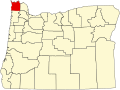
| County | Clatsop |
| Area | |
• Total | 2.26 sq mi (5.86 km2) |
| • Land | 2.24 sq mi (5.80 km2) |
| • Water | 0.02 sq mi (0.06 km2) |
| Elevation | 203 ft (62 m) |
| Population | |
• Total | 853 |
| • Density | 380.80/sq mi (147.05/km2) |
| Time zone | UTC-8 (Pacific (PST)) |
| • Summer (DST) | UTC-7 (PDT) |
| ZIP code | 97103 |
| Area code(s) | 503 and 971 |
| FIPS code | 41-71800 |
| GNIS feature ID | 2812874 [2] |
Svensen is an unincorporated community and census-designated place (CDP) on the Columbia River in Clatsop County, Oregon, United States, named after early settler Peter Svensen. [4] There was a post office in Svensen from 1895 to 1944. [4] [5] Since the closure of the Svensen Post Office, mail service has been provided by rural carriers of the Astoria, Oregon post office. Svensen is within the Knappa School District.