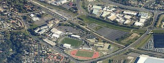
Campbelltown is a town located on the outskirts of the metropolitan area of Sydney, New South Wales, Australia. It is located in Greater Western Sydney 53 kilometres (33 mi) south-west of the Sydney central business district by road. Campbelltown is the administrative seat of the local government area of the City of Campbelltown. It is also acknowledged on the register of the Geographical Names Board of New South Wales as one of only four cities within the Sydney metropolitan area.

Camden is a historic town and suburb of Sydney, New South Wales, located 65 kilometres from the Sydney central business district. Camden was the administrative centre for the local government area of Camden Council until July/August 2016 and is a part of the Macarthur region.

Eagle Vale is a suburb of Sydney, in the state of New South Wales, Australia. Eagle Vale is located 56 kilometres south-west of the Sydney central business district, in the local government area of the City of Campbelltown and is part of the Macarthur region.
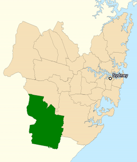
The Division of Macarthur is an Australian electoral division in the state of New South Wales.

Airds is a suburb of Sydney, in the state of New South Wales, Australia. Airds is 56 kilometres south-west of the Sydney central business district, in the local government area of the City of Campbelltown and is part of the Macarthur region.
Ambarvale is a suburb of south-western Sydney in the state of New South Wales, Australia. Ambarvale is located 55 kilometres south-west of the Sydney central business district, in the local government area of the City of Campbelltown and is part of the Macarthur region. The suburb is predominantly residential and contains a mix of public and private housing.

The City of Campbelltown is a local government area in the Macarthur region of south-western Sydney, in New South Wales, Australia. The area is located about 55 kilometres (34 mi) south west of the Sydney central business district and comprises 312 square kilometres (120 sq mi).

Woodbine is a suburb of Sydney, in the state of New South Wales, Australia. It is 55 kilometres south-west of the Sydney central business district, in the local government area of the City of Campbelltown and is part of the Macarthur region. Woodbine shares the postcode of 2560 with Campbelltown.
Minto Heights is a suburb of Sydney, in the state of New South Wales, Australia 50 kilometres south-west of the Sydney central business district, in the local government area of the City of Campbelltown. It is part of the Macarthur region.
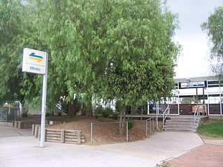
Minto is a suburb of Sydney, in the state of New South Wales, Australia. Minto is located 38 kilometres south-west of the Sydney central business district, in the local government area of the City of Campbelltown and is part of the Macarthur region.
Leumeah is a suburb of Sydney, in the state of New South Wales, Australia 39 kilometres south-west of the Sydney central business district, in the local government area of the City of Campbelltown. It is north of the suburb of Campbelltown and is part of the Macarthur region.
Spring Farm is a suburb of the Macarthur Region of Sydney in the state of New South Wales, Australia in Camden Council. It is on the east side of the Nepean River. Until recently, it was mainly farmland with a winery, an electricity substation and the Spring Farm Advanced Resource Recovery Facility, but it is currently in the process of suburban redevelopment.

Rosemeadow is a suburb of Sydney, in the state of New South Wales, Australia. Rosemeadow is located 56 kilometres south-west of the Sydney central business district, in the local government area of the City of Campbelltown and is part of the Macarthur region.
Edmondson Park is a suburb of Sydney, in the state of New South Wales, Australia. Edmondson Park is located 32 kilometres south-west of the Sydney central business district, in the local government area of the City of Liverpool. Some Southern areas near Bardia is part of City of Campbelltown LGA.

Eschol Park is a suburb of Sydney, in the state of New South Wales, Australia. Eschol Park is located 60 kilometres south-west of the Sydney central business district, in the local government area of the City of Campbelltown and is part of the Macarthur region.

Glen Alpine is a suburb of Sydney, in the state of New South Wales, Australia. Glen Alpine is located 56 kilometres south-west of the Sydney central business district, in the local government area of the City of Campbelltown and is part of the Macarthur region.

Macarthur is a region in the south-west of Sydney, in the state of New South Wales, Australia. The region includes the local government areas of the City of Campbelltown, Camden Council and Wollondilly Shire. It covers an area of 3,067 square kilometres and has a population of close to 310,000 residents. The region geographically forms the foothills between the Blue Mountains and Southern Highlands regions.

Macarthur Square is a large indoor/outdoor shopping centre located in the south western Sydney suburb of Campbelltown, New South Wales, Australia. The shopping centre was opened by the Lend Lease Corporation and GPT Group on 10 September 1979. The shopping centre is situated adjacent to Macarthur Railway Station, where trains terminate on the Airport & South Line.
The Cordeaux River, a perennial river of the Hawkesbury-Nepean catchment, is located in the Southern Highlands and Macarthur regions of New South Wales, Australia.
Bardia is a suburb of Sydney, in the state of New South Wales, Australia located 44 kilometres (27 mi) south-west of the Sydney central business district, in the local government areas of the City of Campbelltown and City of Liverpool. It is part of the Macarthur region.