Minto, New South Wales

Last updated

Minto
Sydney,  New South Wales
Minto Station 3.jpg
Minto railway station
Minto, New South Wales
Map
Population13,940 (2021 census) [1]
Established1882
Postcode(s) 2566
Elevation70 m (230 ft)
Location50 km (31 mi) SW of Sydney
LGA(s) City of Campbelltown
State electorate(s) Macquarie Fields
Federal division(s) Werriwa
Suburbs around Minto:
Ingleburn Ingleburn Ingleburn
Bow Bowing Minto Minto Heights
Woodbine Leumeah Kentlyn

Minto is a suburb of Sydney, in the state of New South Wales, Australia. Minto is located 50 kilometres south-west of the Sydney central business district, in the local government area of the City of Campbelltown and is part of the Macarthur region.

Contents

History

Minto was named in honour of the Earl of Minto, Gilbert Elliot-Murray-Kynynmound, who was Viceroy of India from 1807 to 1814. The name was originally given to the entire district stretching from just north of Appin up to what is now Denham Court. [2]

The area that constitutes the current suburb of Minto was originally home to the indigenous Tharawal people until the arrival of European settlers from the First Fleet. [3] [4] In 1811, Governor Lachlan Macquarie granted 800 acres (3.2 km2) in the area to William Redfern, the colony's first surgeon. He in turn named it Campbellfield after Macquarie's wife Elizabeth whose maiden name was Campbell. Redfern used the property as a vineyard and sheep station.

In 1810, Dr Robert Towson built his sandstock home, Varroville, in St Andrews Road, on land granted by Governor Macquarie. The house was subsequently owned by Charles Sturt and James Raymond, the first Postmaster General. In the 1820s, Colonel Parker built a Georgian bungalow called Epping Forest in Raby Road. A farm called Robin Hood Farm was built in Campbelltown Road circa 1830. These three properties are now listed on the Register of the National Estate. [5]

In 1874, a railway station was built in the area and named Campbellfield after the property but this led to confusion with nearby Campbelltown so in 1882, it was renamed Minto. Development of the area followed shortly after and by the 1950s it was a village of around 500 people.

A large slice of land on the east side of Minto was sold to Housing Commission in 1969 to provide cheap housing. Shortly after a large industrial estate was also established in the area and Minto's transition from village to Sydney suburb was complete.

Heritage listings

Minto has a number of heritage-listed sites, including:

Transport

Minto railway station is on the Main Southern railway line. Minto also has a small inland port connected by rail to Port Botany. The inland port consists of a single rail siding with an adjacent hard stand surface for the containers, and the siding is operated by top and tail trains with engines at both ends.

Schools

Minto is home to two high schools, Sarah Redfern High and Alfaisal College; five primary schools, Campbellfield Public, Minto Public, Sarah Redfern Public, The Grange Public and Alfaisal College; and a special school, Passfield Park, which services disabled students from pre-school through to high school. [7]

Rugby League players, Michael Lett, Gray Vaine, Justin Brooker, John Skandalis, Ken McGuinness, Kevin McGuinness, Israel Folau, Mickey, Lopini and Lelea Paea, Tim Lafai and Byron Fruean all attended Sarah Redfern High School, a notable rugby league school.[ citation needed ]

Housing

Public housing belonging to Housing NSW has recently been demolished in the suburb new housing estate called One Minto. This decision had been made in an attempt to break the generational cycle of a socially disadvantaged suburb that the Minto estate had infamously been known for over the past few decades. Because of this concentration of disadvantage, the One Minto Estate experienced a range of social issues including high unemployment and poor health, low income, high percentage of single parent families, a lack of access to educational opportunities and other services and high crime rates. The majority of the houses will be private with around 850 privately owned houses compared to only 360 public housing homes. [8] The public housing has been evenly spread among the suburb, in efforts to prevent concentrated areas of welfare dependency.

Although the One Minto estate sits at approximately 30 percent public housing, the suburb as a whole has 15 percent in total.

People

Demographics

At the 2021 census, the population of Minto was 13,940.

At the 2016 census, there were 12,551 people in Minto. [9]

Notable residents

Sport and recreation

Minto Sports Centre MintoNSWSportsCentre.jpg
Minto Sports Centre

The Minto Indoor Sports Centre is home to local basketball and netball teams. The Macarthur Heat plays in the New South Wales State Basketball League and uses the Centre as its home court. The Campbelltown District Netball Association, which is also based at the Centre, plays in the third division of the Netball NSW State League. [10] [11] [12] [13]

Minto has a rugby league team, the Minto Cobras playing in the Western Suburbs District Junior Rugby League. The Cobras home ground is Townson Oval. They have produced a number of NRL players including Israel Folau, Michael Lett, Gray Vaine, Justin Brooker, John Skandalis, Ken McGuinness, Kevin McGuinness, Jarryd Hayne, Mickey Lopini, Lalea Paea, Krisnan Inu and Tim Lafai. Mickey Paea, a current Bulldogs forward, always gives up his extra time and helps out Minto Cobras. The club is proud of him for doing that because not many NRL players would give up spare time to go visit the clubs where they played their junior footy. [14]

Related Research Articles

<span class="mw-page-title-main">Campbelltown, New South Wales</span> City in New South Wales, Australia

Campbelltown is a suburb located on the outskirts of the metropolitan area of Sydney, New South Wales, Australia. It is located in Greater Western Sydney 53 kilometres (33 mi) south-west of the Sydney central business district by road. Campbelltown is the administrative seat of the local government area of the City of Campbelltown. It is also acknowledged on the register of the Geographical Names Board of New South Wales as one of only four cities within the Sydney metropolitan area.

<span class="mw-page-title-main">Waterloo, New South Wales</span> Suburb of Sydney, New South Wales, Australia

Waterloo is an inner southern suburb of Sydney, New South Wales, Australia. Waterloo is located three kilometres (1.9 mi) south of the Sydney central business district and is part of the local government area of the City of Sydney. Waterloo is surrounded by the suburbs of Redfern and Darlington to the north, Eveleigh and Alexandria to the west, Rosebery to the south, and Moore Park, Zetland, and Kensington to the east.

<span class="mw-page-title-main">Redfern, New South Wales</span> Inner suburb of Sydney, Australia

Redfern is an inner southern suburb of Sydney located 3 kilometres (1.9 mi) south of the Sydney central business district and is part of the local government area of the City of Sydney. Strawberry Hills is a locality on the border with Surry Hills. The area experienced the process of gentrification and is subject to extensive redevelopment plans by the state government, to increase the population and reduce the concentration of poverty in the suburb and neighbouring Waterloo.

<span class="mw-page-title-main">Auburn, New South Wales</span> Suburb of Cumberland City Council, New South Wales, Australia

Auburn is a Western Sydney suburb in the state of New South Wales, Australia. Auburn is located 16 kilometres (9.9 mi) west of the Sydney central business district and is in the local government area of Cumberland City Council, having previously been the administrative centre of Auburn Council. The suburb was named after Oliver Goldsmith's poem The Deserted Village, which describes 'Auburn' in England as the "loveliest village of the plain".

<span class="mw-page-title-main">Macquarie Fields, New South Wales</span> Suburb of Sydney, New South Wales, Australia

Macquarie Fields is a suburb of Sydney, in the state of New South Wales, Australia. Macquarie Fields is located 38 kilometres south-west of the Sydney central business district, in the local government area of the City of Campbelltown and is part of the Macarthur region.

<span class="mw-page-title-main">Western Suburbs Magpies</span> Australian rugby league club, based in Sydney, NSW

The Western Suburbs Magpies is an Australian rugby league football club based in the western suburbs of Sydney, New South Wales. Formed in 1908, Wests, as the club is commonly referred to, was one of the nine foundation clubs of the first New South Wales Rugby League competition in Australia. The club, as a sole entity, departed the top-flight competition in 1999 after forming a 50–50 joint venture with Balmain Tigers to form the Wests Tigers. The club currently fields sides in the NSW State Cup, Ron Massey Cup (Opens), S.G. Ball Cup and Harold Matthews Cup competitions.

<span class="mw-page-title-main">Airds, New South Wales</span> Suburb of Sydney, New South Wales, Australia

Airds is a predominantly residential suburb of Sydney. Houses within the suburb are owned by Housing NSW.

<span class="mw-page-title-main">Minto railway station</span> Railway station in Sydney, New South Wales, Australia

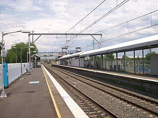
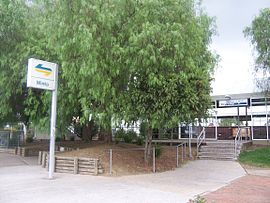
Minto railway station is located on the Main Southern line, serving the Sydney suburb of Minto. It is served by Sydney Trains T8 Airport & South line services.

<span class="mw-page-title-main">Moorebank, New South Wales</span> Suburb of Sydney, New South Wales, Australia

Moorebank is a suburb of Sydney, in the state of New South Wales, Australia. Moorebank is located 27 kilometres south-west of the Sydney central business district in the local government area of the City of Liverpool.

<span class="mw-page-title-main">Ingleburn, New South Wales</span> Suburb of Sydney, New South Wales, Australia

Ingleburn is a suburb of Sydney, in the state of New South Wales, Australia 45 kilometres south-west of the Sydney central business district, in the local government area of City of Campbelltown. It is part of the Macarthur region. Ingleburn is located approximately halfway between the two commercial centres of Liverpool and Campbelltown.

<span class="mw-page-title-main">Long Point, New South Wales</span> Suburb of Sydney, New South Wales, Australia

Long Point is a suburb of Sydney, in the state of New South Wales, Australia. Long Point is located 46 kilometres south-west of the Sydney central business district, in the local government area of the City of Campbelltown.

<span class="mw-page-title-main">John Skandalis</span> Australian rugby league footballer

John Skandalis is an Australian former professional rugby league footballer who played as a prop in the 1990s, 2000s and 2010s.

Westfields Sports High School is a government-funded co-educational comprehensive and specialist secondary day school, with speciality in sports, located in Fairfield West, a western suburb of Sydney, New South Wales, Australia.

<span class="mw-page-title-main">Mickey Paea</span> Tonga international rugby league footballer

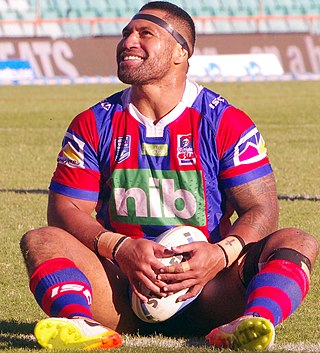
Mickey Paea is a former Tonga international rugby league footballer who played as a prop.

Lelea Paea is a former Tonga international rugby league footballer. He previously played for Coca-Cola West Red Sparks rugby union in Japan. He usually plays centre, but has played in wing at times throughout his career.

<span class="mw-page-title-main">Lopini Paea</span> Former Tonga international rugby league footballer

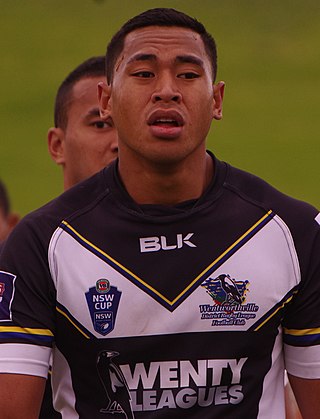
Lopini Paea is a Tonga international rugby league footballer who last played for the Sydney Roosters in the National Rugby League. He previously played for the Wakefield Trinity Wildcats and the Catalans Dragons in the Super League. His preferred position is prop.

<span class="mw-page-title-main">Tim Lafai</span> Samoa international rugby league footballer

Timoteo Lafai is a Samoan professional rugby league footballer who plays as a centre for the Salford Red Devils in the Super League and Samoa at international level..

Tongan Australians are Australians who are of ethnic Tongan descent or Tongans who hold Australian citizenship.

<span class="mw-page-title-main">John Folau</span> Tonga international rugby league & union footballer

John Folau is a rugby league and rugby union footballer who plays for the Sydney Rays in the National Rugby Championship competition. He is a former Tonga international rugby league footballer.

Minto Cobras Rugby League Football Club is an Australian rugby league football club based in Minto, New South Wales. In 2009 their clubhouse was burnt down and were forced to relocate. They are one of the strongest junior clubs in the Campbelltown area and have produced quality first graders and internationals.

References

  1. 1 2 Australian Bureau of Statistics (28 June 2022). "Minto". 2021 Census QuickStats. Retrieved 24 August 2023. OOjs UI icon edit-ltr-progressive.svg
  2. Minto History
  3. "Campbelltown's environment" (PDF). Campbelltown City Council. Archived from the original (PDF) on 13 September 2006. Retrieved 25 January 2008.
  4. "History of Camden". Camden Historical Society. Retrieved 25 January 2008.
  5. The Heritage of Australia, Macmillan Company, 1981, p.2/21
  6. "Stone Cottage". New South Wales State Heritage Register . Department of Planning & Environment. H01388. Retrieved 18 May 2018. CC BY icon.svg Text is licensed by State of New South Wales (Department of Planning and Environment) under CC-BY 4.0 licence .
  7. "Passfield Park School". NSW Department of Education. Retrieved 6 April 2008.
  8. "We're here to help with housing".
  9. "2016 Census QuickStats: Minto".
  10. "Minto Indoor Sports centre". Campbelltown City Council. Archived from the original on 28 July 2008. Retrieved 6 April 2008.
  11. "State Basketball League". Basketball NSW. Retrieved 6 April 2008.
  12. "State League Div 3". Netball NSW. Archived from the original on 14 July 2011. Retrieved 6 April 2008.
  13. "Campbelltown District Netball Association". Campbelltown District Netball Association. Retrieved 6 April 2008.
  14. "Israel Folau". News Limited. Archived from the original on 29 March 2008. Retrieved 6 April 2008.

34°1′35″S150°51′3″E / 34.02639°S 150.85083°E / -34.02639; 150.85083