
Krishna district is a district in the coastal Andhra Region in Indian state of Andhra Pradesh, with Machilipatnam as its administrative headquarters. It is surrounded on the East by Bay of Bengal, West by Guntur, Bapatla and North by Eluru and NTR districts and South again by Bay of Bengal.
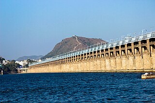
Vijayawada, formerly known as Bezawada, is the second largest city in the Indian state of Andhra Pradesh. It is located on the banks of the Krishna River surrounded by the hills of the Eastern Ghats, known as the Indrakeeladri Hills. The city is home to the important Hindu shrine of Kanaka Durga Temple. It geographically lies on the center spot of Andhra Pradesh. The city has been described as the commercial, political, cultural and educational capital of Andhra Pradesh. It is the administrative headquarters of NTR district. The Prakasam Barrage across the Krishna River connects the NTR and Guntur districts.

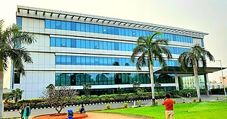
Gannavaram is a suburb of Vijayawada in Krishna district of the Indian state of Andhra Pradesh. It is also the mandal headquarters of Gannavaram mandal which is administered under Gudivada revenue division. It is a major suburb of Vijayawada in the North East side.Vijayawada International Airport, Medha IT Park, IT companies like HCL Tech and TechMahindra are located here.

Nuzvid, natively spelled Nuzividu or Nuziveedu is a city in the Eluru district of the Indian state of Andhra Pradesh. It serves as the administrative headquarters for Nuzvid mandal and Nuzvid revenue division.
Kanur or Kanuru is a neighborhood of Vijayawada in Krishna district of the Indian state of Andhra Pradesh.It is one of the Major educational hub of the city. As per the G.O. No. M.S.104 (dated:23-03-2017), Municipal Administration and Urban Development Department, it became a part of Vijayawada metropolitan area.
Vuyyuru is a town in Krishna district of the Indian state of Andhra Pradesh. It is a Nagar panchayat and the headquarters of Vuyyuru Mandal. It is emerging as neighbourhood of Vijayawada, India situated 30 km away.
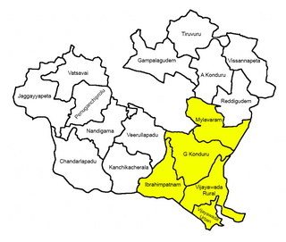
Vijayawada Rural mandal is one of the 20 mandals in NTR district of the Indian state of Andhra Pradesh. It is under the administration of Vijayawada revenue division and has its headquarters at Nunna. The mandal is bounded by Ibrahimpatnam, G. Konduru, Gannavaram, Kankipadu, Penamaluru and Patamata Mandals. The mandal is also a part of the Andhra Pradesh Capital Region under the jurisdiction of APCRDA.
Penamaluru is a Locality of Vijayawada in Krishna district of the Indian state of Andhra Pradesh. It is the mandal headquarters of Penamaluru mandal. As per the G.O. No. M.S.104 (dated:23-03-2017), Municipal Administration and Urban Department, it became a part of vijayawada metropolitan area.
Gollapudi is a commercial and residential hub located in western part of Vijayawada in the Indian state of Andhra Pradesh. It falls under Vijayawada Rural mandal in Vijayawada revenue division of NTR district. As per the G. O. No. M. S. 104, Municipal Administration and Urban Development Department, it is a part of Vijayawada Metropolitan Area.

Ramavarappadu is a residential hub located in the East-Central part of Vijayawada in NTR district of the Indian state of Andhra Pradesh.It is one of the major locality of the City.The nearest localities to Ramavarappadu are Currency Nagar ,Gunadala ,Prasadampadu
Nunna is a part of Vijayawada in NTR district of the Indian state of Andhra Pradesh. It is the headquarters of Vijayawada (rural) mandal in Vijayawada revenue division. As per the G.O. No. M.S.104 (dated:23-03-2017), Municipal Administration and Urban Development Department, it became a part of Vijayawada metropolitan area. The biggest Mango market in Asia, called Nunna Mango Market is located at Nunna. And 400 kv Vijayawada Power grid is also here. Polavaram Right Canal goes through Nunna. And State Capital Vijayawada-Amaravati Inner Ring Road is covering the Nunna.

Tadepalli is a major residential Area of the Vijayawada in Guntur district of Indian state of Andhra Pradesh. It is a major south sub urban of Vijayawada and a part of Vijayawada metropolitan area and Andhra Pradesh Capital Region. It is situated on National Highway 16 between Vijayawada and Guntur.
Yanamalakuduru is part of Vijayawada and a census town in Krishna district of the Indian state of Andhra Pradesh. It is located in Penamaluru mandal of Vijayawada revenue division. As per the G.O. No. M.S.104 (dated:23-03-2017), Municipal Administration and Urban Development Department, it became a part of Vijayawada metropolitan area.
Poranki is a Major Locality of Vijayawada in Krishna district of the Indian state of Andhra Pradesh.It is the fastest growing area of the city. As per the G.O. No. M.S.104 (dated:23-03-2017), Municipal Administration and Urban Development Department, it became a part of Vijayawada metropolitan area. It is 2 KM from Penamaluru.
Kesarapalle is a Locality and major IT hub in Vijayawada city in Krishna district of the Indian state of Andhra Pradesh. It is located in Gannavaram mandal of Gudivada revenue division.

Ganguru is a neighbourhood of Vijayawada in Krishna district of the Indian state of Andhra Pradesh. As per the G.O. No. M.S.104 (dated:23-03-2017), Municipal Administration and Urban Development Department, it became a part of Vijayawada metropolitan area. It is located in Penamaluru mandal of Vijayawada revenue division.
Penamaluru mandal is one of the 25 mandals in Krishna district of the Indian state of Andhra Pradesh. Penamaluru Mandal is the major suburb of Vijayawada.It is under the administration of Vuyyuru revenue division and its headquarters are located at Penamaluru. The mandal lies on the banks of Krishna River and is bounded by Vijayawada (urban), Vijayawada (rural) and Kankipadu mandals. The mandal is also a part of the Andhra Pradesh Capital Region under the jurisdiction of APCRDA.
Vijayawada revenue division is an administrative division in the NTR district of the Indian state of Andhra Pradesh. It is one of the 3 revenue divisions in the district with 8 mandals under its administration. Vijayawada serves as the headquarters of the division. The division has 1 municipality and 1 municipal corporation.

Prasadampadu is a part of Vijayawada in NTR district of the Indian state of Andhra Pradesh. It is located in Vijayawada (rural) mandal of Vijayawada revenue division. As per the G.O. No. M.S.104 (dated:23-03-2017), Municipal Administration and Urban Development Department, it became a part of Vijayawada metropolitan area.

NTR district is a district in coastal Andhra Region in the Indian state of Andhra Pradesh. The district headquarters is located at Vijayawada. The district is named after former Chief Minister of Andhra Pradesh N. T. Rama Rao. The district shares boundaries with Guntur, Palnadu, Krishna, Eluru, Khammam and Suryapet districts

