
Fatehpur Sikri is a town in the Agra District of Uttar Pradesh, India. Situated 35.7 kilometres (22.2 mi) from the district headquarters of Agra, Fatehpur Sikri itself was founded as the capital of the Mughal Empire in 1571 by Emperor Akbar, serving this role from 1571 to 1585, when Akbar abandoned it due to a campaign in Punjab and was later completely abandoned in 1610.

Agra is a city on the banks of the Yamuna river in the Indian state of Uttar Pradesh, about 230 kilometres (140 mi) south-east of the national capital Delhi and 330 km west of the state capital Lucknow. With a population of roughly 1.6 million, Agra is the fourth-most populous city in Uttar Pradesh and twenty-third most populous city in India.

The Lahore Fort is a citadel in the city of Lahore in Punjab, Pakistan. The fortress is located at the northern end of Walled city of Lahore and spreads over an area greater than 20 hectares. It contains 21 notable monuments, some of which date to the era of Emperor Akbar. The Lahore Fort is notable for having been almost entirely rebuilt in the 17th century, when the Mughal Empire was at the height of its splendor and opulence.

Burhanpur is a historical city in the Indian state of Madhya Pradesh. It is the administrative seat of Burhanpur District. It is situated on the north bank of the Tapti River and 512 kilometres (318 mi) northeast of city of Mumbai, 340 kilometres (211 mi) southwest of the state's capital city of Bhopal. The city is a Municipal Corporation.
Dhar is a city located in Dhar district of the Malwa region in the state of Madhya Pradesh, India. The city is the administrative headquarters of the Dhar district. Before Indian independence from Great Britain, it was the capital of the Dhar princely state.

Mandu or Mandavgad is an ancient city in the present-day Mandav area of the Dhar district. It is located in the Malwa and Nimar region of western Madhya Pradesh, India, at 35 km from Dhar city. In the 11th century, Mandu was the sub division of the Tarangagadh or Taranga kingdom. This fortress town on a rocky outcrop about 100 km (62 mi) from Indore is celebrated for its architecture.

The Agra Fort is a historical fort in the city of Agra, and also known as Agra's Red Fort. Mughal emperor Humayun was crowned at this fort. It was later renovated by the Mughal emperor Akbar from 1565 and the present-day structure was completed in 1573. It served as the main residence of the rulers of the Mughal dynasty until 1638, when the capital was shifted from Agra to Delhi. It was also known as the "Lal-Qila" or "Qila-i-Akbari". Before capture by the British, the last Indian rulers to have occupied it were the Marathas. In 1983, the Agra fort was inscribed as a UNESCO World Heritage Site because of its importance during the Mughal Dynasty. It is about 2.5 kilometers (1.6 mi) northwest of its more famous sister monument, the Taj Mahal. The fort can be more accurately described as a walled city. It was later renovated by Shah Jahan.
Mughal architecture is the type of Indo-Islamic architecture developed by the Mughals in the 16th, 17th and 18th centuries throughout the ever-changing extent of their empire in the Indian subcontinent. It developed from the architectural styles of earlier Muslim dynasties in India and from Iranian and Central Asian architectural traditions, particularly Timurid architecture. It also further incorporated and syncretized influences from wider Indian architecture, especially during the reign of Akbar. Mughal buildings have a uniform pattern of structure and character, including large bulbous domes, slender minarets at the corners, massive halls, large vaulted gateways, and delicate ornamentation; examples of the style can be found in modern-day Afghanistan, Bangladesh, India and Pakistan.

Firozabad district forms one of the western districts of the Indian state of Uttar Pradesh, which has Firozabad city as its district headquarters. The district is a part of the Agra division.

Jhansi district is one of the districts of Uttar Pradesh state in northern India. The city of Jhansi is the district headquarters. The district is bordered on the north by Jalaun District, to the east by Hamirpur and Mahoba districts, to the south by Tikamgarh District of Madhya Pradesh state, to the southwest by Lalitpur District, which is joined to Jhansi District by a narrow corridor, and on the east by the Datia and Bhind districts of Madhya Pradesh. Population 19,98,603. Lalitpur District, which extends into the hill country to the south, was added to Jhansi District in 1891, and made a separate district again in 1974.
Buland Darwaza, or the "Door of Victory", was built in 1575 by Mughal emperor Akbar to commemorate his victory over Gujarat. It is the main entrance to the Jama Masjid at Fatehpur Sikri, which is 43 km from Agra, India.

Indo-Islamic architecture is the architecture of the Indian subcontinent produced by and for Islamic patrons and purposes. Despite an initial Arab presence in Sindh, the development of Indo-Islamic architecture began in earnest with the establishment of Delhi as the capital of the Ghurid dynasty in 1193. Succeeding the Ghurids was the Delhi Sultanate, a series of Central Asian dynasties that consolidated much of North India, and later the Mughal Empire by the 15th century. Both of these dynasties introduced Islamic architecture and art styles from West Asia into the Indian subcontinent.

The Bibi Ka Maqbara is a tomb located in Aurangabad, Maharashtra, India. It was commissioned in 1660 by the Mughal emperor Aurangzeb's son prince Azam Shah in the memory of his loving mother Dilras Banu Begum. It bears a striking resemblance to the Taj Mahal, the mausoleum of Aurangzeb's mother, Mumtaz Mahal. Aurangzeb was not much interested in architecture though he had commissioned the small, but elegant, Moti Masjid at Delhi. Bibi Ka Maqbara is the second largest structure that Aurangzeb has built, the largest being the Badshahi Mosque.
A Subah was the term for a province (state) in the Mughal Empire. The term was also used by other polities of the Indian subcontinent. The word is derived from Arabic and Persian. The governor/ruler of a Subah was known as a subahdar, which later became subedar to refer to an officer in the Indian Army and Pakistan Army. The subahs were established by badshah (emperor) Akbar during his administrative reforms of years 1572–1580; initially they numbered to 12, but his conquests expanded the number of subahs to 15 by the end of his reign. Subahs were divided into Sarkars, or districts. Sarkars were further divided into Parganas or Mahals. His successors, most notably Aurangzeb, expanded the number of subahs further through their conquests. As the empire began to dissolve in the early 18th century, many subahs became effectively independent, or were conquered by the Marathas or the British.
Ghogha is a census town in Bhavnagar district in the state of Gujarat, India. It is situated on the mid-western bank of the Gulf of Khambhat. It was an important historical commercial port on the Arabian Sea until the development of nearby Bhavnagar in the nineteenth century.

Ustad Ahmad Lahori (c.1580–1649) also known as Ahmad Ma'mar Lahori was the chief Mughal architect during the reign of emperor Shah Jahan. He was responsible for the construction of several of the Mughal monuments, including the Taj Mahal in Agra and the Red fort in Delhi; both of which are World Heritage sites. He also designed the Jama Mosque in Delhi.

Narnala Fort or Narnala Qila Sarkar, also known as Shahnoor Fort, is a hill fortress in the Satpura Range of Vidarbh, Maharashtra, India, named after the Rajput Solanki Chaulukya Ruler, Raja Narnal Singh, also known as Narnal Singh Swami. It was renamed as "Shahnoor" by Islamic rulers but again acquired, rebuilt and got its name "Narnala" by ruler Rao Rana Narnal Singh Solanki, who migrated from Patan in Gujarat.

The Jama Mosque is a 17th-century congregational mosque located in the historic core of Agra, Uttar Pradesh. It was built by Jahanara Begum, the eldest daughter of Mughal Emperor Shah Jahan, during the latter's reign. It is the principal mosque in the city of Agra, and lies close to Agra Fort.
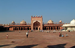
The Jama Masjid is a 16th-century congregational mosque in the UNESCO World Heritage Site of Fatehpur Sikri, located in Uttar Pradesh, India. It was built by Mughal emperor Akbar, and was the largest mosque in the empire at the time of construction. The Jama Masjid's design drew from earlier mosques built by various pre-Mughal sultanates, and served as an important precedent in subsequent Mughal architecture. The site houses the Tomb of Salim Chishti, a saint in whose honour the mosque was constructed.

Persian Inscriptions on Indian Monuments is a book written in Persian by Dr Ali Asghar Hekmat E Shirazi and published in 1956 and 1958 and 2013. New edition contains the Persian texts of more than 200 epigraphical inscriptions found on historical monuments in India, many of which are currently listed as national heritage sites or registered as UNESCO world heritage, published in Persian; an English edition is also being printed.

