
Babina is a cantonment town in Jhansi district in the state of Uttar Pradesh, India. Shree Rajeev Singh Parichha is MLA of Babina constituency.
Jalaun is a city and a municipal board in Jalaun district in the Indian state of Uttar Pradesh.

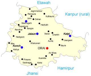
Jalaun district is a district of Uttar Pradesh, India. The district is named after the town of Jalaun, which was the former headquarters of a Maratha governor, but the administrative headquarters of the district is at Orai.

Hamirpur district is one of the 75 districts of Uttar Pradesh state of India and Hamirpur town is the district headquarters. Hamirpur district is a part of Chitrakoot Division. The district occupies an area of 4,121.9 km². The district has a population of 1,104,285. As of 2011 it is the third least populous district of Uttar Pradesh, after Mahoba and Chitrakoot. Two major rivers Yamuna and Betwa meet here. On the banks of river Betwa lies the "Coarse sand" which is exported to many parts in U.P.

Tikamgarh district is one of the 52 districts of Madhya Pradesh state in central India. Tikamgarh town is the district headquarters. The district is part of Sagar Division.

Lalitpur District is one of the districts of Uttar Pradesh state of India. Lalitpur district is a part of Jhansi Division. Lalitpur is the main town and administrative headquarters. The district occupies an area of 5,039 km².

Jhansi district is one of the districts of Uttar Pradesh state in northern India. The city of Jhansi is the district headquarters. The district is bordered on the north by Jalaun District, to the east by Hamirpur and Mahoba districts, to the south by Tikamgarh District of Madhya Pradesh state, to the southwest by Lalitpur District, which is joined to Jhansi District by a narrow corridor, and on the east by the Datia and Bhind districts of Madhya Pradesh. Population 19,98,603. Lalitpur District, which extends into the hill country to the south, was added to Jhansi District in 1891, and made a separate district again in 1974.
Hamirpur is a city and a municipal board in Hamirpur district in the Indian state of Uttar Pradesh. Located just above the confluence of the Yamuna and Betwa rivers, it is the administrative headquarters of Hamirpur district.

Robertsganj also known as Sonbhadra City is a city and a municipal board in Sonbhadra district in the Indian state of Uttar Pradesh.
Chandpur is a town and a municipal board in Bijnor district in the Indian state of Uttar Pradesh, India.
Dhampur is a city and a municipal board in Bijnor district in the state of Uttar Pradesh, India. It is located at 29.51°N 78.50°E, and lies in Northern India.
Gursarai is a city and municipal board in the Jhansi district of the Indian state of Uttar Pradesh. Gursarai is situated in the Garautha Tehsil. An emerging city in Jhansi District With having an old and established market, it's a lifeline for the nearby village people who come and sell their farm produces.
Maudaha is a city and a Municipal Board in Hamirpur district, Uttar Pradesh, India.
Chakia is a small town and the sub-divisional headquarters of Chakia Tehsil in the District of Chandauli of Varanasi Division in the northern Indian state of Uttar Pradesh.
Parichha Thermal Power Station is located at Parichha in Jhansi district in the Indian state of Uttar Pradesh, about 25 km from Jhansi on the bank of Betwa river. The power plant is owned and operated by Uttar Pradesh Rajya Vidyut Utpadan Nigam which is a state enterprise.
Parichha Dam, built on the Betwa River near Parichha town, which is about 25 km from Jhansi on the Jhansi-Kanpur National Highway No. 25. Its reservoir is used by the Parichha Thermal Power Station for electricity generation. The reservoir's impounded water that runs to Notghat Bridge, 34 km away from Jhansi - is popular for water sports.
Ait is a small town located in Jalaun district of Uttar Pradesh.
Huruhuri is a village about 2 km north from the Gomti River in the tehsil of Kerakat, Jaunpur, Uttar Pradesh, India. It belongs to the Varanasi Division. It is located 25 km east of the city of Jaunpur, 4 km west of Kerakat, and 274 km from Lucknow, the capital of Uttar Pradesh. Hurhuri's Postal Index Number is 222142 and the postal head office is situated in Kerakat and Branch Office is JaiGopalGanj. Huruhuri is situated Near State Highway 36.
Khandrawali is a large village located in Kairana tehsil of Shamli district in the Indian state of Uttar Pradesh.
Poonchh is a historic village in the Indian state of Uttar Pradesh. It is situated on national highway 27 in Moth Tehsil in the district of Jhansi, India.

