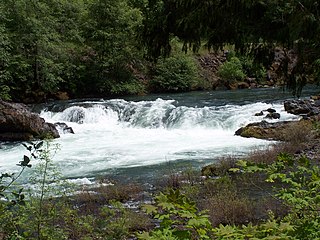
Salt Creek Falls is a cascade and plunge waterfall on Salt Creek, a tributary of the Middle Fork Willamette River, that plunges into a gaping canyon near Willamette Pass in the Willamette National Forest, near Oakridge, Oregon. The waterfall is notable for its main drop of 286 feet (87 m) which makes it the third highest plunge waterfall in Oregon after Multnomah Falls and Watson Falls the second highest, which was re-measured in 2009 and found to be 293 feet rather than an earlier measurement of 272 feet passing Salt Creek Falls. The pool at the bottom of the waterfall is 20 metres (66 ft) deep.

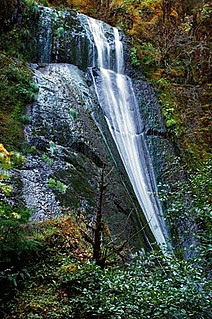
Yakso Falls is a 70-foot (21 m) waterfall on Little River, in the Cascade Range east of Roseburg in the U.S. state of Oregon. The waterfall is about 27 miles (43 km) from the unincorporated community of Glide along Little River Road, which becomes Forest Road 27.

Cavitt Creek is a tributary of the Little River in Douglas County in the U.S. state of Oregon. From its source near Red Butte, the creek flows generally west then north through the Umpqua National Forest of the Cascade Range before entering the river about 1.5 miles (2.4 km) upstream of the rural community of Peel and 7 miles (11 km) above the Little River's mouth on the North Umpqua River.
Alkali Falls, is a multi-step waterfall of 6 tiers located in the east side of the Rogue–Umpqua Divide Wilderness, just west of Mount Bailey and Diamond Lake, on Oregon Route 230 in douglas County, in the U.S. state of Oregon. It totals 510 feet fall in six drops, the Upper Alkali and tallest drop is 130 feet, making it one of the tallest cascades in Oregon.

Cavitt Creek Falls, is a waterfall located on the west edge of the Umpqua National Forest, outside of the town of Glide, in Douglas County, in the U.S. state of Oregon. It totals 8 feet fall in one cascade that shoots into a large swimming bowl and is the centerpiece attraction of the Cavitt Creek Falls trailhead and Recreation Site. Boulders across Cavitt Creek create two channels of water flow that make the cascade and add to a combined width of approximately 15 feet.

Frustration Falls, is a three drop waterfall located on the Salmon River at the south skirt of the Mount Hood National Forest, in Clackamas County, in the U.S. state of Oregon. It is located in a privileged area where the river creates several waterfalls: Final Falls, Vanishing Falls, Little Niagara Falls, and Copper Creek Falls are within a mile from Frustration Falls; while Hideaway Falls, Split Falls, and Stein Falls are approximately two miles away.
Final Falls, is a waterfall located on the Salmon River at the south skirt of the Mount Hood National Forest, in Clackamas County, in the U.S. state of Oregon. It is located in a privileged area where the river creates several waterfalls: Frustration Falls, Vanishing Falls, Little Niagara Falls, and Copper Creek Falls are within a mile from Final Falls; while Hideaway Falls, Split Falls, and Stein Falls are approximately two miles away.
Vanishing Falls, is a waterfall located on the Salmon River at the south skirt of the Mount Hood National Forest, in Clackamas County, in the U.S. state of Oregon. It is located in a privileged area where the river creates several waterfalls: Final Falls, Frustration Falls, Little Niagara Falls, and Copper Creek Falls are within a mile from Vanishing Falls; while Hideaway Falls, Split Falls, and Stein Falls are approximately two miles away.
Little Niagara Falls, is a waterfall located on the Salmon River at the south skirt of the Mount Hood National Forest, in Clackamas County, in the U.S. state of Oregon. It is located in a privileged area where the river creates several waterfalls: Final Falls, Vanishing Falls, Frustration Falls, and Copper Creek Falls are within a mile from Little Niagara Falls; while Hideaway Falls, Split Falls, and Stein Falls are approximately two miles away.
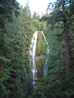
Proxy Falls, also known as Lower Proxy Falls, is a cascade and plunge waterfall from a collection of springs on the shoulder of North Sister, that plunges into a gaping canyon near McKenzie Pass in the Willamette National Forest, near Belknap Springs, Oregon. The waterfall is notable for its main drop of 226 feet (69 m) which makes it one of the highest plunge waterfalls in Oregon.
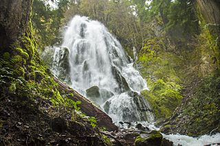
Moon Falls, also spelled Moonfalls, is a waterfall located on the west edge of the Umpqua National Forest in Lane County, in the U.S. state of Oregon. It totals 100 feet fall in one wide veiling cascade and is 1.5 miles from Spirit Falls trailhead.

Upper Butte Creek Falls, is a waterfall located in the south edge of the Table Rock Wilderness at the east end of the city of Salem, in Marion County, in the U.S. state of Oregon. It is located in a privileged area on the east foothills of Drake Crossing. Several prominent rivers and waterfalls are located in the Butte Creek Falls trail system.
Wolf Creek Falls, is a two tier waterfall located on the west skirt of the Umpqua National Forest, in Douglas County, in the U.S. state of Oregon. It is located in a privileged area where rivers of the forest create several waterfalls: Cavitt Creek Falls, and Shadow Falls are within five miles of Wolf Creek Falls. Grotto Falls is further to the east off Little River Road and National Forest Road 2703.
Wildwood Falls, also known as Row River Falls, is a waterfall located on the west skirt of the Umpqua National Forest, in Lane County, in the U.S. state of Oregon. It is located in a privileged area on the west foothills where Willamette National Forest meets with the Umpqua National Forest.
Beaver Creek Falls, is a small waterfall located at the confluence of Beaver and Sweet Creeks in Lane County, in the U.S. state of Oregon. The waterfall is known for joining of the two creeks becoming one intertwined waterfall.
Beaver Falls, is a waterfall located on Beaver Creek near the town of Clatskanie in Columbia County, in the U.S. state of Oregon.
Clover Falls, also known in the past as Upper Hemlock Falls, is a waterfall from the Hemlock Creek, in the heart of the Umpqua National Forest, just north of Hemlock Lake and its campground, in Douglas County, Oregon. Access to Clover Falls is from the Lake of the Woods campground. The waterfall is located in a privileged natural area where the river creates several waterfalls; Hemlock Falls, Yakso Falls, and Tributary Falls are within a mile distance.
Hemlock Falls is a waterfall from the Hemlock Creek, in the heart of the Umpqua National Forest, just north of Hemlock Lake and its campground, in Douglas County, Oregon. Access to Hemlock Falls is from the Lake in the Woods campground. The waterfall is located in a privileged natural area where the river creates several waterfalls: Clover Falls, Yakso Falls, and Tributary Falls are within a mile distance.
Drift Creek Falls is a waterfall formed west of Valley of the Giants, east side of the city of Lincoln City in Lincoln County, Oregon. Access to Drift Creek Falls is located along a trail constructed by the Forest Service in the 1990s and features a 240 foot long suspension bridge crossing Drift Creek.

Eagle Creek Upper Falls, also called Upper Eagle Creek Falls, is a small waterfall located in Clackamas County, in the U.S. state of Oregon. The waterfall is known for a fish ladder that bypasses the waterfall to assist fish navigate the waterfall. Eagle Creek is known for being a point for fishing chinook salmon, bull trout, and steelhead trout.