Farmington, Arkansas

Last updated

Farmington, Arkansas
Arkansas 170.jpg
Looking south along Highway 170
Motto: 
"Feels Like Home" [1]
Washington County Arkansas Incorporated and Unincorporated areas Farmington Highlighted 0523170.svg
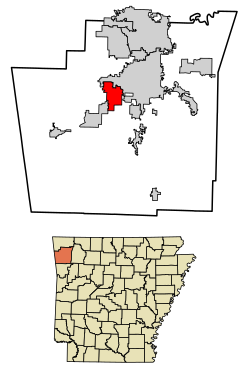
Location of Farmington in Washington County, Arkansas.
Coordinates: 36°02′07″N94°14′18″W / 36.03528°N 94.23833°W / 36.03528; -94.23833
Country United States
State Arkansas
County Washington
Settled1828 [2]
IncorporatedOctober 15, 1946 [2]
Government
Area
[3]
   City 9.88 sq mi (25.58 km2)
  Land9.83 sq mi (25.45 km2)
  Water0.05 sq mi (0.13 km2)
Elevation
[4]
1,217 ft (371 m)
Population
 (2020)
   City 7,584
  Density771.75/sq mi (297.99/km2)
   Metro
463,402
Time zone UTC-6 (Central (CST))
  Summer (DST) UTC-5 (CDT)
ZIP code
72730
Area code 479
FIPS code 05-23170
GNIS feature ID2403598 [4]
Website City of Farmington Arkansas

Farmington is a city in Washington County, Arkansas, United States. The community is nestled in a valley among the Boston Mountains, a subset of the Ozark Mountains. Although the first settlers came from the Deep South in 1828, the community did not incorporate until 1946. Located immediately west of Fayetteville in the Northwest Arkansas metropolitan statistical area, Farmington has been experiencing a population boom in recent years, as indicated by a 66% growth in population between the 2000 and 2010 censuses. [2] It has been characterized as a bedroom community by the University of Arkansas Community Design Center. [5]

Contents

History

Settlement through Civil War

The first settlers came from the Deep South in 1828, and the area was known as Engel's Mill until a post office was built in 1868 and the village was renamed. The Civil War had a great impact on the community, as the area were mainly Confederates. The Battle of Prairie Grove occurred not far from Farmington, and the city was subject to raids by both armies as well as unaffiliated guerrillas and roughnecks.

The city was platted ca. 1870. [6]

Reconstruction through present

Around the 1890s, residents found prosperity by growing strawberries and grapes and shipping them on the St. Louis–San Francisco Railway. The tracks were pulled up during World War II, something the company had wanted to do for years, under the guise of the war effort. Farmington was incorporated on October 15, 1946. [7]

Geography

According to the United States Census Bureau, the city has a total area of 4.8 square miles (12 km2), all land.

Demographics

Historical population
CensusPop.Note
1960 216
1970 908320.4%
1980 1,28341.3%
1990 1,3223.0%
2000 3,605172.7%
2010 5,97465.7%
2020 7,58427.0%
U.S. Decennial Census [8]
2015 Estimate [2] [9]

2020 census

Farmington racial composition [10]
RaceNumberPercentage
White (non-Hispanic)6,04579.71%
Black or African American (non-Hispanic)1982.61%
Native American 1111.46%
Asian 730.96%
Pacific Islander 190.25%
Other/Mixed 6037.95%
Hispanic or Latino 5357.05%

As of the 2020 United States census, there were 7,584 people, 2,584 households, and 1,908 families residing in the city.

2000 census

As of the census [11] of 2000, there were 3,605 people, 1,337 households, and 1,013 families residing in the city. The population density was 750.6 inhabitants per square mile (289.8/km2). There were 1,390 housing units at an average density of 289.4 per square mile (111.7/km2). The racial makeup of the city was 94.01% White, 0.64% Black or African American, 1.75% Native American, 0.25% Asian, 0.94% from other races, and 2.41% from two or more races. 2.19% of the population were Hispanic or Latino of any race.

There were 1,337 households, out of which 43.6% had children under the age of 18 living with them, 58.8% were married couples living together, 14.1% had a female householder with no husband present, and 24.2% were non-families. 19.1% of all households were made up of individuals, and 7.4% had someone living alone who was 65 years of age or older. The average household size was 2.70 and the average family size was 3.09.

In the city, the population was spread out, with 30.7% under the age of 18, 10.3% from 18 to 24, 34.5% from 25 to 44, 16.1% from 45 to 64, and 8.4% who were 65 years of age or older. The median age was 30 years. For every 100 females, there were 93.8 males. For every 100 females age 18 and over, there were 85.3 males.

The median income for a household in the city was $38,969, and the median income for a family was $43,472. Males had a median income of $30,317 versus $21,250 for females. The per capita income for the city was $15,387. About 5.2% of families and 7.5% of the population were below the poverty line, including 7.3% of those under age 18 and 12.1% of those age 65 or over.

Economy

Farmington borders Fayetteville to the west and sections of Fayetteville along Highway 16 are north of the city.

Culture, contemporary life, and points of interest

Annual cultural events

Farmington hosts annual events throughout the year.

Education

Farmington High School takes on Prairie Grove in the annual "Battle for 62" rivalry game, the first home game played in Cardinals Stadium Prairie Grove at Farmington 2019.jpg
Farmington High School takes on Prairie Grove in the annual "Battle for 62" rivalry game, the first home game played in Cardinals Stadium

Farmington School District provides elementary and secondary to students in most areas. [13] Farmington's comprehensive high school is Farmington Career Academies, more popularly referred to as Farmington Highschool. The mascot is the cardinal and their team colors are scarlet red and white.

A portion of Farmington is in the Prairie Grove School District and another portion is in the Fayetteville School District. [13] Prairie Grove High School and Fayetteville High School are these districts' respective comprehensive high schools.

Farmington has two elementary schools, one intermediate (4/5th grade), one middle school (6/7th grade), one Junior High (8/9th), and one High School (Sophomore-Senior). Farmington High School moved into a new building in 2017, including a new Football Field and renovations on old school buildings.

Transportation

As of 2023, there is no fixed route transit service in Farmington. Ozark Regional Transit operates demand-response service in the city. [14] The nearest intercity bus service is provided by Jefferson Lines in nearby Fayetteville. [15]

Notable people

See also

Related Research Articles

<span class="mw-page-title-main">Washington County, Arkansas</span> County in Arkansas, United States

Washington County is a regional economic, educational, and cultural hub in the Northwest Arkansas region. Created as Arkansas's 17th county on November 30, 1848, Washington County has 13 incorporated municipalities, including Fayetteville, the county seat, and Springdale. The county is also the site of small towns, bedroom communities, and unincorporated places. The county is named for George Washington, the first President of the United States.

<span class="mw-page-title-main">Franklin County, Arkansas</span> County in Arkansas, United States

Franklin County is a county in Arkansas. As of the 2020 census, the population was 17,097. The county has two county seats, Charleston and Ozark. The county was formed on December 19, 1837, and named for Benjamin Franklin, American statesman. Franklin County is a damp county, with alcohol sales allowed except in Prairie & Alix townships, and limits on liquor sales in the city of Branch.

<span class="mw-page-title-main">Faulkner County, Arkansas</span> County in Arkansas, United States

Faulkner County is located in the Central Arkansas region of the U.S. state of Arkansas. As of the 2020 census, the population was 123,498, making it the fifth most populous of Arkansas's 75 counties. The county seat and largest city is Conway. Faulkner County was created on April 12, 1873, one of nine counties formed during Reconstruction, and is named for Sandford C. Faulkner, better known as Sandy Faulkner, a popular figure in the state at the time.

<span class="mw-page-title-main">Benton County, Arkansas</span> County in Arkansas, United States

Benton County is a county within the Northwest Arkansas region with a culture, economy, and history that have transitioned from rural and agricultural to suburban and white collar since the growth of Walmart, which is headquartered in Benton County. Created as Arkansas's 35th county on September 30, 1836, Benton County contains thirteen incorporated municipalities, including Bentonville, the county seat, and Rogers, the most populous city. The county was named after Thomas Hart Benton, a U.S. Senator from Missouri influential in Arkansas statehood.

<span class="mw-page-title-main">Elm Springs, Arkansas</span> City in Arkansas, United States

Elm Springs is a city in Benton and Washington Counties, Arkansas, United States. Located immediately west of Springdale in the Northwest Arkansas metropolitan statistical area, Elm Springs has been gaining population in recent years, including a 47% increase in population between the 2000 and 2010 censuses.

<span class="mw-page-title-main">Gentry, Arkansas</span> City in Arkansas, United States

Gentry is a city in Benton County, Arkansas, United States. The population was 3,790 as of the 2020 census. The city was founded in the Ozark Mountains in 1894 along what would become the Kansas City Southern Railroad. The city's prior prosperity in the orchard industry, especially apples, was further strengthened by the rail connection. Following the decline of the apple industry in the 1930s, Gentry shifted its economy towards poultry along with many other areas of Northwest Arkansas.

<span class="mw-page-title-main">Lowell, Arkansas</span> City in Arkansas, United States

Lowell is a city in Benton County, Arkansas, United States. Located within the Ozarks, the first settlement was along Old Wire Road in the 1840s, and although destroyed during the Civil War, the community was reestablished by J. R. McClure and thrived when the St. Louis–San Francisco Railway came through the area in the 1880s. The city is a growing bedroom community within the rapidly growing Northwest Arkansas region. Lowell is the headquarters of trucking company J.B. Hunt. Lowell's population was 9,839 at the 2020 census, an increase of 34% since 2010.

<span class="mw-page-title-main">Springdale, Arkansas</span> City in Arkansas, United States

Springdale is the fourth-most populous city in Arkansas, United States. It is located in both Washington and Benton counties in Northwest Arkansas. Located on the Springfield Plateau deep in the Ozark Mountains, Springdale has long been an important industrial city for the region. In addition to several trucking companies, the city is home to the world headquarters of Tyson Foods, the world's largest meat producing company. Originally named Shiloh, the city changed its name to Springdale when applying for a post office in 1872. It is included in the four-county Northwest Arkansas Metropolitan Statistical Area, which is ranked 102nd in terms of population in the United States with 546,725 in 2020 according to the United States Census Bureau. The city had a population of 84,161 at the 2020 Census.

<span class="mw-page-title-main">St. Paul, Arkansas</span> Town in Arkansas, United States

St. Paul is a town in Madison County, Arkansas, United States. The population was 111 at the 2020 census. It is on the edge of the Northwest Arkansas region.

<span class="mw-page-title-main">Elkins, Arkansas</span> City in Arkansas, United States

Elkins is a city in Washington County, Arkansas, United States. The community is located in the Boston Mountains, deep in the Ozark Mountains. A combination of the former unincorporated communities of Harris and Hood, Elkins was established in 1964. Located immediately east of Fayetteville in the Northwest Arkansas metropolitan statistical area, Elkins has been experiencing rapid growth in recent years, doubling in population between the 2000 and 2010 censuses.

<span class="mw-page-title-main">Fayetteville, Arkansas</span> City in Arkansas, United States

Fayetteville is the second-most populous city in Arkansas, the county seat of Washington County, and the most populous city in Northwest Arkansas. The city is on the outskirts of the Boston Mountains, deep within the Ozarks. Known as Washington until 1829, the city was named after Fayetteville, Tennessee, from which many of the settlers had come. It was incorporated on November 3, 1836, and was rechartered in 1867. Fayetteville is included in the three-county Northwest Arkansas Metropolitan Statistical Area, which is ranked 100th in terms of population in the United States with 576,403 in 2022 according to the United States Census Bureau. The city had a population of 99,285 in 2022.

<span class="mw-page-title-main">Goshen, Arkansas</span> City in Arkansas, United States

Goshen is a city in Washington County, Arkansas, United States. The population was 2,102 at the 2020 census. It is part of the Northwest Arkansas region. According to Business Insider, it is the “most educated” city in the state of Arkansas.

<span class="mw-page-title-main">Greenland, Arkansas</span> City in Arkansas, United States

Greenland is a city in Washington County, Arkansas, United States. The population is 1,213 as of the 2020 census. The community is located in the Boston Mountains, within the Ozark Mountains.

<span class="mw-page-title-main">Johnson, Arkansas</span> City in Arkansas, United States

Johnson is a city in Washington County, Arkansas, United States. The community is located in the Ozark Mountains and is surrounded by valleys and natural springs. Early settlers took advantage of these natural features and formed an economy based on mining lime, the Johnson Mill and trout. Although a post office was opened in the community in 1887, Johnson did not incorporate until it required the development of a city government to provide utility services in 1961. Located between Fayetteville and Springdale in the heart of the rapidly growing Northwest Arkansas metropolitan statistical area, Johnson has been experiencing a population and building boom in recent years, as indicated by a 46% growth in population between the 2000 and 2010 censuses.

<span class="mw-page-title-main">Lincoln, Arkansas</span> City in Arkansas, United States

Lincoln is a city in Washington County, Arkansas, United States. The population was 2,294 at the 2020 census. It is part of the Northwest Arkansas metro area.

<span class="mw-page-title-main">Prairie Grove, Arkansas</span> City in Arkansas

Prairie Grove is a city in Washington County, Arkansas, United States. The population was 7,045 at the 2020 Census. It is part of the Northwest Arkansas region, and home to Prairie Grove Battlefield State Park.

<span class="mw-page-title-main">Tontitown, Arkansas</span> City in Arkansas, United States

Tontitown is a city in northern Washington County, Arkansas, United States. The community is located in the Ozark Mountains and was founded by Italian settlers in 1898. Known for its grapes and wines, Tontitown has hosted the Tontitown Grape Festival continuously since 1898. It is part of the Northwest Arkansas region, serving as a bedroom community for larger neighbors Fayetteville and Springdale. The town experienced a 160% growth in population between the 2000 and 2010 censuses.

<span class="mw-page-title-main">West Fork, Arkansas</span> City in Arkansas, United States

West Fork is a city in Washington County, Arkansas, United States. The population is 2,331 at the 2020 census. It is part of the Northwest Arkansas region.

<span class="mw-page-title-main">Winslow, Arkansas</span> City in Arkansas, United States

Winslow is a city in southern Washington County, Arkansas, United States. The population was 365 as of the 2020 census. It is part of the Northwest Arkansas region.

<span class="mw-page-title-main">Northwest Arkansas</span> Metropolitan area in Arkansas, United States

Northwest Arkansas (NWA) is a metropolitan area and region in Arkansas within the Ozark Mountains. It includes four of the ten largest cities in the state: Fayetteville, Springdale, Rogers, and Bentonville, the surrounding towns of Benton and Washington counties, and adjacent rural Madison County, Arkansas. The United States Census Bureau-defined Fayetteville–Springdale–Rogers Metropolitan Statistical Area includes 3,213.01 square miles (8,321.7 km2) and 576,403 residents, ranking NWA as the 98th most-populous metropolitan statistical area in the U.S. and the 13th fastest growing in the United States.

References

  1. "City of Farmington Arkansas". City of Farmington Arkansas. Archived from the original on January 20, 2012. Retrieved September 12, 2012.
  2. 1 2 3 4 Noble, Jane (March 1, 2012). "Farmington (Washington County)". Encyclopedia of Arkansas History and Culture . Butler Center for Arkansas Studies at the Central Arkansas Library System . Retrieved June 23, 2013.
  3. "2020 U.S. Gazetteer Files". United States Census Bureau. Retrieved October 29, 2021.
  4. 1 2 U.S. Geological Survey Geographic Names Information System: Farmington, Arkansas
  5. "Farmington Townscape". University of Arkansas. Archived from the original on July 12, 2014. Retrieved June 23, 2013.
  6. History of Benton, Washington, Carroll, Madison, Crawford, Franklin, and Sebastian Counties, Arkansas. Higginson Book Company. 1889. p. 269.
  7. "Farmington, Arkansas". City-Data.com. Retrieved September 12, 2012.
  8. "Census of Population and Housing". Census.gov. Retrieved June 4, 2015.
  9. "Annual Estimates of the Resident Population for Incorporated Places: April 1, 2010 to July 1, 2015". Archived from the original on October 19, 2016. Retrieved June 4, 2016.
  10. "Explore Census Data". data.census.gov. Retrieved January 1, 2022.
  11. "U.S. Census website". United States Census Bureau . Retrieved January 31, 2008.
  12. 1 2 3 Rice, Karen (2022). "Farmington: a vital metropolis with a family-friendly feel". West Washington County Directory. Northwest Arkansas Newspapers LLC. p. 10.
  13. 1 2 "2020 CENSUS - SCHOOL DISTRICT REFERENCE MAP: Washington County, AR" (PDF). U.S. Census Bureau . Retrieved September 17, 2022.
  14. "Demand Response" . Retrieved September 28, 2023.
  15. "Arkansas Bus Stops" . Retrieved September 28, 2023.