
Washington County is a regional economic, educational, and cultural hub in the Northwest Arkansas region. Created as Arkansas's 17th county on November 30, 1848, Washington County has 13 incorporated municipalities, including Fayetteville, the county seat, and Springdale. The county is also the site of small towns, bedroom communities, and unincorporated places. The county is named for George Washington, the first President of the United States.
Independence County is a county located in the U.S. state of Arkansas. As of the 2020 census, the population was 37,938. The county seat is Batesville. Independence County is Arkansas's ninth county, formed on October 20, 1820, from a portion of Lawrence County and named in commemoration of the Declaration of Independence. It is an alcohol prohibition or dry county.

Greene County is a county located in the U.S. state of Arkansas. As of the 2020 census, the population was 45,736. The county seat is Paragould, which sits atop Crowley's Ridge.
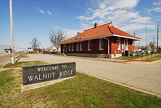
Walnut Ridge is a city in and the county seat of Lawrence County, Arkansas, United States. The population was 5,098 at the United States Census's 2019 estimate. Walnut Ridge lies immediately north of Hoxie. The two towns form a contiguous urban area with approximately 8,000 residents. Williams Baptist University is in College City, a formerly separate community that merged into Walnut Ridge in 2017.

Farmington is a city in Washington County, Arkansas, United States. The community is nestled in a valley among the Boston Mountains, a subset of the Ozark Mountains. Although the first settlers came from the Deep South in 1828, the community did not incorporate until 1946. Located immediately west of Fayetteville in the Northwest Arkansas metropolitan statistical area, Farmington has been experiencing a population boom in recent years, as indicated by a 66% growth in population between the 2000 and 2010 censuses. It has been characterized as a bedroom community by the University of Arkansas Community Design Center.

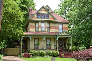
Prairie Grove is a city in Washington County, Arkansas, United States. The population was 7,045 at the 2020 Census. It is part of the Northwest Arkansas region, and home to Prairie Grove Battlefield State Park.

The Southwest Trail was a 19th-century pioneer route that was the primary passageway for American settlers bound for Texas.
Walnut Grove may refer to:

Arkansas Highway 25 is a northeast–southwest state highway in north central Arkansas. The route runs 85.66 miles (137.86 km) from US 64 in Conway to US 63/412 in Black Rock through Heber Springs, Batesville, and the foothills of The Ozarks.

Arkansas Highway 170 is a designation for two state highways in Washington County, Arkansas. The main segment of 17.31 miles (27.86 km) runs from Devil's Den State Park to West Fork. A shorter segment of 5.44 miles (8.75 km) runs from U.S. Route 62 (US 62) through Appleby before reconnecting with US 62.

Highway 34 is an east–west state highway in the Upper Arkansas Delta. The route of 40.18 miles (64.66 km) begins at US Highway 412 (US 412) and U.S. Route 67 Business (US 67B). The route is maintained by the Arkansas State Highway and Transportation Department (AHTD).

Sixteen special routes of U.S. Route 62 currently exist. Seven of them lie within the state of Arkansas. Three existed in the past but have since been decommissioned.

Center Township is one of 37 townships in Washington County, Arkansas, USA. At the 2010 census, its total population was 1,518.
Walnut Grove, Arkansas may refer to:
Viney Grove is an unincorporated community in Marrs Hill Township, Washington County, Arkansas, United States. It is located north of Prairie Grove and Prairie Grove Battlefield State Park along County Road 37.
Walnut Grove was an unincorporated community in Jackson Township, Pope County, Arkansas, United States. It was located on Walnut Grove Road, east of Hector. The Walnut Grove cemetery and church are approximately one mile apart at the location indicated with the cemetery adjacent to Dare Creek and the church on a hilltop one mile to the south.

Walnut Grove Methodist Church is a historic church in rural western Pulaski County, Arkansas. It is located southwest of Little Rock, on the east side of Walnut Grove Road between County Roads 38 and 31. The modest wood-frame building has a single story, a gabled roof, rough-cut clapboard siding, and regional Greek Revival ornamentation. Its interior is finished with wooden planking, and it retains original period pews of similarly simple construction. Built in 1885, it is the oldest church in Pulaski County.

Walnut Grove Presbyterian Church is a historic church in rural Washington County, Arkansas. It is located southwest of Farmington, on the east side of Arkansas Highway 170. It is a modest single-story brick church, with a cross-gable roof and a squat square belltower. Each of its gable ends is adorned with a large three-part stained glass window. It was built in 1903 for a congregation established in 1856, and is a locally distinctive vernacular interpretation of the Romanesque Revival.

The Walnut Grove Cemetery is a historic cemetery in rural Independence County, Arkansas, United States, on Walden Road, just north of Arkansas Highway 25, northwest of Cord. Established in 1840, it is one of the oldest cemeteries in the area, set on what was once the only major roadway through the region. It is the only significant surviving element of the community of Walnut Grove, which was located at a locally important crossroads in the 19th century.
Walnut Ridge School District was a school district headquartered in Walnut Ridge, Arkansas. Walnut Ridge Elementary School and Walnut Ridge High School were its schools.


