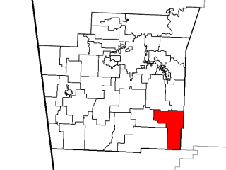
Yell County is a county in the U.S. state of Arkansas. As of the 2020 census, the population was 20,263. The county has two county seats, Dardanelle and Danville. Yell County is Arkansas's 42nd county, formed on December 5, 1840, from portions of Scott and Pope counties. It was named after Archibald Yell, who was the state's first member of the United States House of Representatives and the second governor of Arkansas. He died in combat at the Battle of Buena Vista during the Mexican–American War.

Washington County is a regional economic, educational, and cultural hub in the Northwest Arkansas region. Created as Arkansas's 17th county on November 30, 1848, Washington County has 13 incorporated municipalities, including Fayetteville, the county seat, and Springdale. The county is also the site of small towns, bedroom communities, and unincorporated places. The county is named for George Washington, the first President of the United States.

Bradley County is a county located in the U.S. state of Arkansas. As of the 2020 census, the population was 10,545. The county seat is Warren. It is Arkansas's 43rd county, formed on December 18, 1840, and named for Captain Hugh Bradley, who fought in the War of 1812.

Salida is the statutory city that is the county seat and the most populous municipality of Chaffee County, Colorado, United States. The population was 5,666 at the 2020 census.

Paradise Valley is a census-designated place (CDP) in Humboldt County, Nevada, United States, near the Santa Rosa Ranger District of Humboldt National Forest. It is located at the northern terminus of Nevada State Route 290, about 19 miles (31 km) northeast of U.S. Highway 95 and a total of 40 miles (64 km) north of Winnemucca. The town is located in a broad valley, with the Santa Rosa Range of mountains just to the northwest. At the 2010 census, the population of the CDP was 109.
Dan Franklin Morse is an archaeologist specializing in the prehistory of the midwestern United States and the central Mississippi Valley, research summarized in a number of books, monographs, and technical articles. He is best known for his 1983 synthesis of the "Archaeology of the Central Mississippi Valley" with Phyllis A. Morse, and for his 1997 volume issued by the Smithsonian Institution Press on "Sloan: A Paleoindian Dalton Cemetery in Arkansas." The Sloan site is the location of the oldest marked cemetery found to date in the Americas. He conducted excavations on a great many other significant archaeological sites during his career, including at Brand, Cahokia, Nodena, Parkin, and Zebree. Morse retired from his posts as Survey Archeologist for the Arkansas Archaeological Survey and as Professor of Anthropology at the University of Arkansas in 1997, after 30 years of service, but continues to work on publications and interact with students and colleagues on sites.
Durham is an unincorporated community in eastern Washington County, Arkansas, United States. The community is on Arkansas Highway 16 along the White River valley between Elkins to the northwest and Thompson in Madison County to the southeast. Its elevation is 1,247 feet (380 m).

The Arkansas River Valley is a region in Arkansas defined by the Arkansas River in the western part of the state. Generally defined as the area between the Ozark and Ouachita Mountains, the River Valley is characterized by flat lowlands covered in fertile farmland and lakes periodically interrupted by high peaks. Mount Magazine, Mount Nebo, and Petit Jean Mountain compose the Tri-Peaks Region, a further subdivision of the River Valley popular with hikers and outdoors enthusiasts. In addition to the outdoor recreational activities available to residents and visitors of the region, the River Valley contains Arkansas's wine country as well as hundreds of historical sites throughout the area. It is one of six natural divisions of Arkansas.

Clyde is an unincorporated community in Cane Hill Township, Washington County, Arkansas, United States. Clyde is on Arkansas Highway 45, approximately 26 miles southwest of Fayetteville and six miles east of the Oklahoma border.
Hogeye is an unincorporated community in Valley Township, Washington County, Arkansas, United States. It is located on Arkansas Highway 265 and Arkansas Highway 156.
Hubbard is an unincorporated community in Valley Township, Washington County, Arkansas, United States. It is located near the intersection of Washington County Road 21 and Hubbard Road.
Pitkin Corner is an unincorporated community in West Fork Township, Washington County, Arkansas, United States. It is located on Washington County Road 35 west of the Woolsey Bridge.
Morrow is an unincorporated community and census-designated place (CDP) in Washington County, Arkansas, United States. A post office has been in operation at Morrow since 1883; The community had the name of G. W. Morrow, an early postmaster. it was first listed as a CDP in the 2020 census with a population of 263;
Viney Grove is an unincorporated community in Marrs Hill Township, Washington County, Arkansas, United States. It is located north of Prairie Grove and Prairie Grove Battlefield State Park along County Road 37.

Reed Township is one of thirty-seven townships in Washington County, Arkansas, USA. As of the 2000 census, its total population was 410.
Rhea is an unincorporated community in Rhea's Mill Township, Washington County, Arkansas, United States. It is located on a county road north of Lincoln and Lincoln Lake. Weddington Mountain is just to the west.
Sunset is an unincorporated community in Reed Township, Washington County, Arkansas, United States. It is located at the intersection of Sunset Road and CR 110.
Tolu is an unincorporated community in Vineyard Township in western Washington County, Arkansas, United States. It is located at the intersection of Highway 59 and Bellamy Road about one half mile from the Arkansas - Oklahoma border. The community of Evansville lies approximately 1.3 miles to the south, across Evansville Creek.
Valley Township is one of 21 inactive townships in Madison County, Arkansas, United States. As of the 2010 census, its population was 517.


