Lucas County is a county located in the northwestern part of the U.S. state of Ohio. It is bordered to the east by Lake Erie, and to the southeast by the Maumee River, which runs to the lake. As of the 2020 census, the population was 431,279. Its county seat and largest city is Toledo, located at the mouth of the Maumee River on the lake. The county was named for Robert Lucas, 12th governor of Ohio, in 1835 during his second term. Its establishment provoked the Toledo War conflict with the Michigan Territory, which claimed some of its area. Lucas County is the central county of the Toledo Metropolitan Statistical Area.

Maumee is a city in Lucas County, Ohio, United States. Located along the Maumee River, it is a suburb about 10 miles (16 km) southwest of Toledo. The population was 13,896 at the 2020 census. Maumee was declared an All-America City by the National Civic League in June 2006.

Waterville is a city in Lucas County, Ohio, United States, along the Maumee River. A suburb of Toledo, the population was 6,003 at the 2020 census.

The Battle of Fallen Timbers was the final battle of the Northwest Indian War, a struggle between Native American tribes affiliated with the Northwestern Confederacy and their British allies, against the nascent United States for control of the Northwest Territory. The battle took place amid trees toppled by a tornado near the Maumee River in northwestern Ohio at the site of the present-day city of Maumee, Ohio.

The Maumee River is a river running in the United States Midwest from northeastern Indiana into northwestern Ohio and Lake Erie. It is formed at the confluence of the St. Joseph and St. Marys rivers, where Fort Wayne, Indiana has developed, and meanders northeastwardly for 137 miles (220 km) through an agricultural region of glacial moraines before flowing into the Maumee Bay of Lake Erie. The city of Toledo is located at the mouth of the Maumee. The Maumee was designated an Ohio State Scenic River on July 18, 1974. The Maumee watershed is Ohio's breadbasket; it is two-thirds farmland, mostly corn and soybeans. It is the largest watershed of any of the rivers feeding the Great Lakes, and supplies five percent of Lake Erie's water.

The Wabash and Erie Canal was a shipping canal that linked the Great Lakes to the Ohio River via an artificial waterway. The canal provided traders with access from the Great Lakes all the way to the Gulf of Mexico. Over 460 miles long, it was the longest canal ever built in North America.

U.S. Route 24 (US 24) is one of the original United States highways of 1926. It originally ran from Pontiac, Michigan, in the east to Kansas City, Missouri, in the west. Today, the highway's eastern terminus is in Independence Township, Michigan at an intersection with I-75, and its western terminus is near Minturn, Colorado at an intersection with I-70. The highway transitions from north–south to east–west signage at the Ohio-Michigan state line.
Roche is a Swiss healthcare company.
The Odawa, believed to derive from an Anishinaabe word meaning "traders", are an Indigenous American ethnic group who primarily inhabit land in the Eastern Woodlands region, commonly known as the northeastern United States and southeastern Canada. They have long had territory that crosses the current border between the two countries, and they are federally recognized as Native American tribes in the United States and have numerous recognized First Nations bands in Canada. They are one of the Anishinaabeg, related to but distinct from the Ojibwe and Potawatomi peoples.
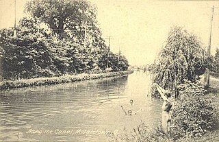
The Miami and Erie Canal was a 274-mile (441 km) canal that ran from Cincinnati to Toledo, Ohio, creating a water route between the Ohio River and Lake Erie. Construction on the canal began in 1825 and was completed in 1845 at a cost to the state government of $8,062,680.07. At its peak, it included 19 aqueducts, three guard locks, 103 canal locks, multiple feeder canals, and a few man-made water reservoirs. The canal climbed 395 feet (120 m) above Lake Erie and 513 feet (156 m) above the Ohio River to reach a topographical peak called the Loramie Summit, which extended 19 miles (31 km) between New Bremen, Ohio to lock 1-S in Lockington, north of Piqua, Ohio. Boats up to 80 feet long were towed along the canal by mules, horses, or oxen walking on a prepared towpath along the bank, at a rate of four to five miles per hour.

Fort Miami (Miamis) was a British fort built in spring 1794 on the Maumee River in what was at the time territory claimed by the United States, and designated by the federal government as the Northwest Territory. The fort was located at the eastern edge of present-day Maumee, Ohio, southwest of Toledo. The British built the fort to forestall a putative assault on Fort Detroit by Gen. "Mad" Anthony Wayne's army, then advancing northward in southwestern Ohio.

Metroparks Toledo, officially the Metropolitan Park District of the Toledo Area, is a public park district consisting of parks, nature preserves, a botanical garden, trail network and historic battlefield in Lucas County, Ohio.

Providence is a ghost town on the north side of the Maumee River in southern Providence Township, Lucas County, Ohio, United States, about 24 miles (39 km) southwest of Toledo. After suffering a destructive fire and a cholera epidemic in mid-19th century, the village was abandoned. In this period, canal traffic had also fallen off.

Harvard Terrace is a historic neighborhood in Toledo, Ohio; it is "bordered by Amherst Drive, Broadway, Glendale Avenue, and the Anthony Wayne Trail. It includes 435 residences, many of them designed by architects and built in the early 1900s."
Bend View Metropark is a regional park located in Waterville, Ohio, owned and managed by Metroparks Toledo and named for its view of a 90-degree bend in the Maumee River.

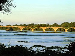
The Interurban Bridge, also known as the Ohio Electric Railroad Bridge. is a historic interurban railway reinforced concrete multiple arch bridge built in 1908 to span the Maumee River joining Lucas and Wood counties near Waterville, Ohio. The span was once the world's largest earth-filled reinforced concrete bridge. One of the bridge's supports rests on the Roche de Boeuf, a historic Indian council rock, which was partially destroyed by the bridge's construction. The bridge, which is no longer in use, is a popular subject for photographers and painters, who view it from Farnsworth Metropark.

Blue Creek Metropark is a park and conservation area in Whitehouse and Waterville Township, Ohio, owned by Metroparks Toledo and partially leased to the city of Whitehouse.

The Twelve Mile Square Reservation, also called the Twelve Mile Square Reserve, was a tract of land in Ohio ceded by Indians to the United States of America in the Treaty of Greenville in 1795. This particular area of land immediately surrounding Fort Miami was considered to be of strategic importance by the United States government representatives. It was subsequently surveyed in a manner different from surrounding land, and lots sold, or granted, to settlers.
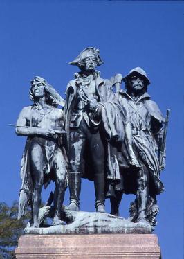
The Battle of Fallen Timbers Monument or Anthony Wayne Memorial is a statuary group created by Bruce Saville.