Demographics
| | This section is empty. You can help by adding to it. (June 2021) |
Fines Creek, North Carolina | |
|---|---|
| Coordinates: 35°40′52″N82°57′04″W / 35.681°N 82.951°W Coordinates: 35°40′52″N82°57′04″W / 35.681°N 82.951°W | |
| Country | United States |
| State | North Carolina |
| County | Haywood |
| Elevation | 2,520 ft (770 m) |
| Time zone | UTC-5 (Eastern (EST)) |
| • Summer (DST) | UTC-4 (EDT) |
| ZIP code | 28721 |
| Area code | 828 |
| GNIS feature ID | 1020244 |
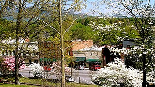
Fines Creek is a populated place within the township of Fines Creek in Haywood County, North Carolina, United States.
Prior to European colonization, the area that is now Fines Creek was inhabited by the Cherokee people and other Indigenous peoples for thousands of years. The Cherokee in Western North Carolina are known as the Eastern Band of Cherokee Indians, a federally recognized tribe.
Fines Creek is located at latitude 35.681 and longitude -82.951. The elevation is 2,520 feet. [1]
| | This section is empty. You can help by adding to it. (June 2021) |
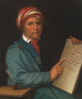
The Cherokee are one of the indigenous peoples of the Southeastern Woodlands of the United States. Prior to the 18th century, they were concentrated in their homelands, in towns along river valleys of what is now southwestern North Carolina, southeastern Tennessee, edges of western South Carolina, northern Georgia, and northeastern Alabama.

Swain County is a county located on the far western border of the U.S. state of North Carolina. As of the 2020 census, the population was 14,117. Its county seat is Bryson City.

Jackson County is a county located in the far southwest of the U.S. state of North Carolina. As of the 2020 census, the population was 43,109. Since 1913 its county seat has been Sylva, which replaced Webster.

Graham County is a county located in the U.S. state of North Carolina. As of the 2020 census, the population was 8,030, making it the third-least populous county in North Carolina. Its county seat is Robbinsville.

Cherokee County is the westernmost county in the U.S. state of North Carolina. It borders Tennessee to its west and Georgia to its south. As of the 2020 census, the population was 28,774. The county seat is Murphy, elevation 1604 ft.
Tryon is a town in Polk County, on the southwestern border of North Carolina, United States. As of the 2020 census, the city population was 1,562. Located in the escarpment of the Blue Ridge Mountains, today the area is affluent and a center for outdoor pursuits, equestrian activity, and fine arts.

The Hiwassee River has its headwaters on the north slope of Rocky Mountain in Towns County in the northern area of the State of Georgia. It flows northward into North Carolina before turning westward into Tennessee, flowing into the Tennessee River a few miles west of what is now State Route 58 in Meigs County, Tennessee. The river is about 147 miles (237 km) long.

The Nottely River is a river in the United States. The river originates in the Blue Ridge Mountains in northern Georgia. The river flows for 51.1 miles (82.2 km) into the artificial Hiwassee Reservoir in North Carolina. The Nottely River is dammed in Georgia, creating Lake Nottely. Arkaqua Creek is a tributary.
The Yamasee War was a conflict fought in South Carolina from 1715 to 1717 between British settlers from the Province of Carolina and the Yamasee, who were supported by a number of allied Native American peoples, including the Muscogee, Cherokee, Catawba, Apalachee, Apalachicola, Yuchi, Savannah River Shawnee, Congaree, Waxhaw, Pee Dee, Cape Fear, Cheraw, and others. Some of the Native American groups played a minor role, while others launched attacks throughout South Carolina in an attempt to destroy the colony.

The Tuckasegee River flows entirely within western North Carolina. It begins its course in Jackson County above Cullowhee at the confluence of Panthertown and Greenland creeks.

Junaluska, was a leader of Cherokee who resided in towns in western North Carolina in the early 19th century. He fought alongside Andrew Jackson, and saved his life, at the Battle of Horseshoe Bend during the War of 1812/Creek War. Reportedly later in life, he regretted having done so.

Keowee was a Cherokee town in the far northwest corner of present-day South Carolina. It was the principal town of what were called the seven Lower Towns, located along the Keowee River. Keowee was situated on the Lower Cherokee Traders' Path, part of the Upper Road through the Piedmont. In 1752 the Cherokee established New Keowee Town nearby, off the traders' path but in a more defensible location.
Tugaloo was a Cherokee town located on the Tugaloo River, at the mouth of Toccoa Creek. It was south of Toccoa and Travelers Rest State Historic Site in present-day Stephens County, Georgia. Cultures of ancient indigenous peoples had occupied this area, and those of the South Appalachian Mississippian culture built a platform mound and village here. It was an administrative and ceremonial center for them.
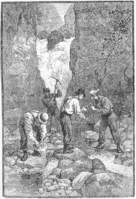
The Georgia Gold Rush was the second significant gold rush in the United States and the first in Georgia, and overshadowed the previous rush in North Carolina. It started in 1829 in present-day Lumpkin County near the county seat, Dahlonega, and soon spread through the North Georgia mountains, following the Georgia Gold Belt. By the early 1840s, gold became difficult to find. Many Georgia miners moved west when gold was found in the Sierra Nevada in 1848, starting the California Gold Rush. Since the 16th century, American Indians in Georgia told European explorers that the small amounts of gold which they possessed came from mountains of the interior. Some poorly documented accounts exist of Spanish or French mining gold in North Georgia between 1560 and 1690, but they are based on supposition and on rumors passed on by Indians. In summing up known sources, W.S. Yeates observed: "Many of these accounts and traditions seem to be quite plausible. Nevertheless, it is hardly probable that the Spaniards would have abandoned mines which were afterwards found to be quite profitable, as those in North Georgia."
The Battle of Taliwa was fought in Ball Ground, Georgia in 1755. The battle was part of a larger campaign of the Cherokee against the Muscogee Creek people, where an army of 500 Cherokee warriors led by Oconostota defeated the Muscogee Creek people and pushed them south from their northern Georgia homelands, allowing the Cherokee to begin settling in the region.

Dellwood is a populated place within the town of Maggie Valley in Haywood County, North Carolina, United States.

The Spikebuck Town Mound and Village Site is a prehistoric and historic archaeological site on Town Creek near its confluence with the Hiwassee River within the boundaries of present-day Hayesville, North Carolina. The site encompasses the former area of the Cherokee village of Quanassee and associated farmsteads. The village was centered on what is known as Spikebuck Mound, an earthwork platform mound, likely built about 1,000 CE by ancestral indigenous peoples during the South Appalachian Mississippian culture period.
The Treaty of Dewitts Corner ended the initial Overhill Cherokee targeted attacks on colonial settlements that took place at the beginning of the American Revolution. A peace document signed by the Cherokee and South Carolina, the treaty instead laid the foundation for the decades long Cherokee–American wars fought between the European-Americans and the Chickamauga Cherokee people.

The Oconaluftee River drains the south-central Oconaluftee valley of the Great Smoky Mountains in Western North Carolina before emptying into the Tuckasegee River. The river flows through the Qualla Boundary, a federal land trust that serves as a reservation for the Eastern Band of the Cherokee (EBCI), the only federally recognized tribe in the state of North Carolina. They bought the land back from the federal government in the 1870s, after having been pushed off and forced to cede it earlier in the nineteenth century. Several historic Cherokee towns are known to have been located along this river.

The historic Cherokee settlements were Cherokee settlements established in Southeastern North America up to the removals of the early 19th century. Several settlements had existed prior to and were initially contacted by explorers and colonists of the colonial powers as they made inroads into frontier areas. Others were established later.
Municipalities and communities of Haywood County, North Carolina, United States | ||
|---|---|---|
| Towns |  | |
| CDPs | ||
| Other communities | ||
| Indian reservation | ||
| Footnotes | ‡This populated place also has portions in an adjacent county or counties | |