The Cherokee are one of the indigenous peoples of the Southeastern Woodlands of the United States. Prior to the 18th century, they were concentrated in their homelands, in towns along river valleys of what is now southwestern North Carolina, southeastern Tennessee, edges of western South Carolina, northern Georgia, and northeastern Alabama.

Cherokee County is a county in the U.S. state of South Carolina. As of the 2020 census, the population was 56,216. The county seat is Gaffney. The county was formed in 1897 from parts of York, Union, and Spartanburg Counties. It was named for the Cherokee people who historically occupied this area prior to European encounter.

Swain County is a county located on the far western border of the U.S. state of North Carolina. As of the 2020 census, the population was 14,117. Its county seat is Bryson City.

Graham County is a county located in the U.S. state of North Carolina. As of the 2020 census, the population was 8,030, making it the third-least populous county in North Carolina. Its county seat is Robbinsville.

Cherokee County is the westernmost county in the U.S. state of North Carolina. It borders Tennessee to its west and Georgia to its south. As of the 2020 census, the population was 28,774. The county seat is Murphy, elevation 1604 ft.
Murphy is a town in and the county seat of Cherokee County, North Carolina, United States. It is situated at the confluence of the Hiwassee and Valley rivers. It is the westernmost county seat in the state of North Carolina, approximately 360 miles (580 km) from the state capital in Raleigh. The population of Murphy was 1,627 at the 2010 census.

Hayesville is a town in Clay County, North Carolina, United States. The population was 311 at the 2010 census. It is the county seat of Clay County.
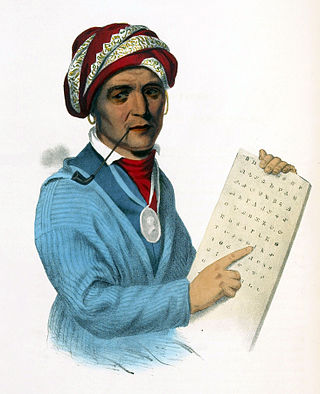
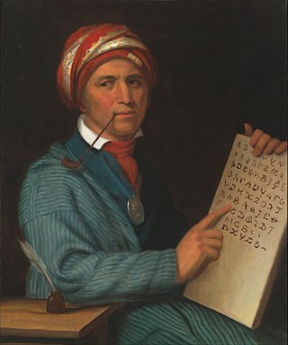
Sequoyah, also known as George Gist or George Guess, was a Native American polymath of the Cherokee Nation. In 1821, he completed his independent creation of the Cherokee syllabary, making reading and writing in Cherokee possible. His achievement was one of the few times in recorded history that an individual who was a member of a pre-literate group created an original, effective writing system. His creation of the syllabary allowed the Cherokee nation to be one of the first North American Indigenous groups to have a written language. Sequoyah was also an important representative for the Cherokee nation, by going to Washington, D.C. to sign two relocations and trading of land treaties.

Unto These Hills is an outdoor historical drama during summers at the 2,800-seat Mountainside Theatre in Cherokee, North Carolina. It is the third oldest outdoor historical drama in the United States, after The Lost Colony in Manteo in eastern North Carolina and The Ramona Pageant in Southern California. The first version of the play was written by Kermit Hunter and opened on July 1, 1950, to wide acclaim.

Cherokee is a census-designated place (CDP) in Swain and Jackson counties in Western North Carolina, United States, within the Qualla Boundary land trust. Cherokee is located in the Oconaluftee River Valley around the intersection of U.S. Routes 19 and 441. As of the 2020 census, the CDP had a population of 2,195. It is the capital of the federally recognized Eastern Band of Cherokee Indians, one of three recognized Cherokee tribes and the only one in North Carolina.

The Qualla Boundary or The Qualla is territory held as a land trust by the United States government for the federally recognized Eastern Band of Cherokee Indians, who reside in western North Carolina. The area is part of the large historic Cherokee territory in the Southeast, which extended into eastern Tennessee, western South Carolina, northern Georgia and Alabama. Currently, the largest contiguous portion of the Qualla lies in Haywood, Swain, and Jackson counties and is centered on the community of Cherokee, which serves as the tribal capital of the Eastern Band of Cherokee Indians. Smaller, discontiguous parcels also lie in Graham and Cherokee counties, near the communities of Snowbird and Murphy respectively.
The Eastern Band of Cherokee Indians (EBCI), is a federally recognized Indian Tribe based in Western North Carolina in the United States. They are descended from the small group of 800–1000 Cherokee who remained in the Eastern United States after the US military, under the Indian Removal Act, moved the other 15,000 Cherokee to west of the Mississippi River in the late 1830s, to Indian Territory. Those Cherokee remaining in the East were to give up tribal Cherokee citizenship and to assimilate. They became US citizens.

The Tuckasegee River flows entirely within western North Carolina. It begins its course in Jackson County above Cullowhee at the confluence of Panthertown and Greenland creeks.
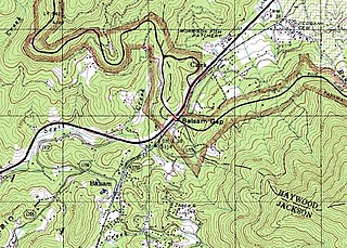
Balsam Gap is a mountain pass between the Plott Balsam Range to the northwest and the Great Balsam Mountains to the southeast on the county line dividing Haywood and Jackson counties in the U.S. state of North Carolina.
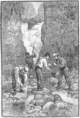
The Georgia Gold Rush was the second significant gold rush in the United States and the first in Georgia, and overshadowed the previous rush in North Carolina. It started in 1829 in present-day Lumpkin County near the county seat, Dahlonega, and soon spread through the North Georgia mountains, following the Georgia Gold Belt. By the early 1840s, gold became difficult to find. Many Georgia miners moved west when gold was found in the Sierra Nevada in 1848, starting the California Gold Rush. Since the 16th century, American Indians in Georgia told European explorers that the small amounts of gold which they possessed came from mountains of the interior. Some poorly documented accounts exist of Spanish or French mining gold in North Georgia between 1560 and 1690, but they are based on supposition and on rumors passed on by Indians. In summing up known sources, W.S. Yeates observed: "Many of these accounts and traditions seem to be quite plausible. Nevertheless, it is hardly probable that the Spaniards would have abandoned mines which were afterwards found to be quite profitable, as those in North Georgia."
The Cherokee have participated in over forty treaties in the past three hundred years.
The Cherokee people of the southeastern United States, and later Oklahoma and surrounding areas, have a long military history. Since European contact, Cherokee military activity has been documented in European records. Cherokee tribes and bands had a number of conflicts during the 18th century with Europeans, primarily British colonists from the Southern Colonies. The Eastern Band and Cherokees from the Indian Territory fought in the American Civil War, with bands allying with the Union or the Confederacy. Because many Cherokees allied with the Confederacy, the United States government required a new treaty with the nation after the war. Cherokees have also served in the United States military during the 20th and 21st centuries.

Cherokee history is the written and oral lore, traditions, and historical record maintained by the living Cherokee people and their ancestors. In the 21st century, leaders of the Cherokee people define themselves as those persons enrolled in one of the three federally recognized Cherokee tribes: The Eastern Band of Cherokee Indians, The Cherokee Nation, and The United Keetoowah Band of Cherokee Indians.

The Oconaluftee River drains the south-central Oconaluftee valley of the Great Smoky Mountains in Western North Carolina before emptying into the Tuckasegee River. The river flows through the Qualla Boundary, a federal land trust that serves as a reservation for the Eastern Band of the Cherokee (EBCI), the only federally recognized tribe in the state of North Carolina. They bought the land back from the federal government in the 1870s, after having been pushed off and forced to cede it earlier in the nineteenth century. Several historic Cherokee towns are known to have been located along this river.

The historic Cherokee settlements were Cherokee settlements established in Southeastern North America up to the removals of the early 19th century. Several settlements had existed prior to and were initially contacted by explorers and colonists of the colonial powers as they made inroads into frontier areas. Others were established later.


