Related Research Articles
The Woods Hole Oceanographic Institution is a private, nonprofit research and higher education facility dedicated to the study of marine science and engineering.

The University of Massachusetts Dartmouth is a public research university in Dartmouth, Massachusetts. It is the southernmost campus of the University of Massachusetts system. Formerly Southeastern Massachusetts University, it was merged into the University of Massachusetts system in 1991.
The Florida Institute of Oceanography (FIO), located on the campus of the University of South Florida St. Petersburg, is an entity of the State University System of Florida that works collaboratively with 32 institutions and agencies from across the state that support marine research.

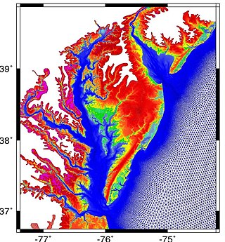
Mesh generation is the practice of creating a mesh, a subdivision of a continuous geometric space into discrete geometric and topological cells. Often these cells form a simplicial complex. Usually the cells partition the geometric input domain. Mesh cells are used as discrete local approximations of the larger domain. Meshes are created by computer algorithms, often with human guidance through a GUI, depending on the complexity of the domain and the type of mesh desired. A typical goal is to create a mesh that accurately captures the input domain geometry, with high-quality (well-shaped) cells, and without so many cells as to make subsequent calculations intractable. The mesh should also be fine in areas that are important for the subsequent calculations.

Henry Melson Stommel was a major contributor to the field of physical oceanography. Beginning in the 1940s, he advanced theories about global ocean circulation patterns and the behavior of the Gulf Stream that form the basis of physical oceanography today. Widely recognized as one of the most influential and productive oceanographers of his time, Stommel was both a groundbreaking theoretician and an astute, seagoing observer.
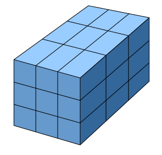
A regular grid is a tessellation of n-dimensional Euclidean space by congruent parallelotopes. Its opposite is irregular grid.
The Naval Physical and Oceanographic Laboratory or NPOL is a laboratory of the Defence Research and Development Organisation (DRDO), under the Ministry of Defence, India. It is situated in Thrikkakara, Kochi, Kerala. NPOL is responsible for the Research & Development of sonar systems, technologies for underwater surveillance, study of ocean environment and underwater materials.
Reservoir simulation is an area of reservoir engineering in which computer models are used to predict the flow of fluids through porous media.
The MIT General Circulation Model (MITgcm) is a numerical computer code that solves the equations of motion governing the ocean or Earth's atmosphere using the finite volume method. It was developed at the Massachusetts Institute of Technology and was one of the first non-hydrostatic models of the ocean. It has an automatically generated adjoint that allows the model to be used for data assimilation. The MITgcm is written in the programming language Fortran.
The Princeton Ocean Model (POM) is a community general numerical model for ocean circulation that can be used to simulate and predict oceanic currents, temperatures, salinities and other water properties. POM-WEB and POMusers.org
MIKE 21 is a computer program that simulates flows, waves, sediments and ecology in rivers, lakes, estuaries, bays, coastal areas and seas in two dimensions. It was developed by DHI.
GSSHA is a two-dimensional, physically based watershed model developed by the Engineer Research and Development Center of the United States Army Corps of Engineers. It simulates surface water and groundwater hydrology, erosion and sediment transport. The GSSHA model is used for hydraulic engineering and research, and is on the Federal Emergency Management Agency (FEMA) list of hydrologic models accepted for use in the national flood insurance program for flood hydrograph estimation. Input is best prepared by the Watershed Modeling System interface, which effectively links the model with geographic information systems (GIS).
Gerris is computer software in the field of computational fluid dynamics (CFD). Gerris was released as free and open-source software, subject to the requirements of the GNU General Public License (GPL), version 2 or any later.
Regional Ocean Modeling System (ROMS) is a free-surface, terrain-following, primitive equations ocean model widely used by the scientific community for a diverse range of applications. The model is developed and supported by researchers at the Rutgers University, University of California Los Angeles and contributors worldwide.
Ocean general circulation models (OGCMs) are a particular kind of general circulation model to describe physical and thermodynamical processes in oceans. The oceanic general circulation is defined as the horizontal space scale and time scale larger than mesoscale. They depict oceans using a three-dimensional grid that include active thermodynamics and hence are most directly applicable to climate studies. They are the most advanced tools currently available for simulating the response of the global ocean system to increasing greenhouse gas concentrations. A hierarchy of OGCMs have been developed that include varying degrees of spatial coverage, resolution, geographical realism, process detail, etc.
FESOM is a multi-resolution ocean general circulation model that solves the equations of motion describing the ocean and sea ice using finite-element and finite-volume methods on unstructured computational grids. The model is developed and supported by researchers at the Alfred Wegener Institute, Helmholtz Centre for Polar and Marine Research (AWI), in Bremerhaven, Germany.
The ADCIRC model is a high-performance, cross-platform numerical ocean circulation model popular in simulating storm surge, tides, and coastal circulation problems. Originally developed by Drs. Rick Luettich and Joannes Westerink, the model is developed and maintained by a combination of academic, governmental, and corporate partners, including the University of North Carolina at Chapel Hill, the University of Notre Dame, and the US Army Corps of Engineers. The ADCIRC system includes an independent multi-algorithmic wind forecast model and also has advanced coupling capabilities, allowing it to integrate effects from sediment transport, ice, waves, surface runoff, and baroclinicity.
Trevor Charles Platt was a British and Canadian biological oceanographer who was distinguished for his fundamental contributions to quantifying primary production by phytoplankton at various scales of space and time in the ocean.
OceanParcels, “Probably A Really Computationally Efficient Lagrangian Simulator”, is a set of python classes and methods that is used to track particles like water, plankton and plastics. It uses the output of ocean general circulation model (OGCMs). OceanParcels main goal is to process the increasingly large amounts of data that is governed by OGCM's. The flow dynamics are simulated using Lagrangian modelling and the geophysical fluid dynamics are simulated with Eulerian modelling or provided through experimental data. OceanParcels is dependent on two principles, namely the ability to read external data sets from different formats and customizable kernels to define particle dynamics.
References
- ↑ Chen, Changsheng; Beardsley, Robert; Cowles, Geoffrey (2006). "An Unstructured Grid, Finite-Volume Coastal Ocean Model (FVCOM) System". Oceanography. 19 (1): 78–89. doi: 10.5670/oceanog.2006.92 . ISSN 1042-8275.