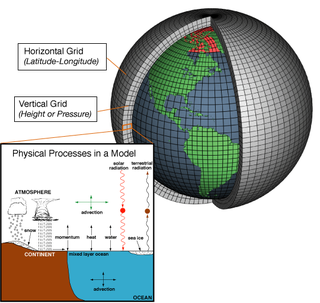
A general circulation model (GCM) is a type of climate model. It employs a mathematical model of the general circulation of a planetary atmosphere or ocean. It uses the Navier–Stokes equations on a rotating sphere with thermodynamic terms for various energy sources. These equations are the basis for computer programs used to simulate the Earth's atmosphere or oceans. Atmospheric and oceanic GCMs are key components along with sea ice and land-surface components.

Numerical weather prediction (NWP) uses mathematical models of the atmosphere and oceans to predict the weather based on current weather conditions. Though first attempted in the 1920s, it was not until the advent of computer simulation in the 1950s that numerical weather predictions produced realistic results. A number of global and regional forecast models are run in different countries worldwide, using current weather observations relayed from radiosondes, weather satellites and other observing systems as inputs.
The National Severe Storms Laboratory (NSSL) is a National Oceanic and Atmospheric Administration (NOAA) weather research laboratory under the Office of Oceanic and Atmospheric Research. It is one of seven NOAA Research Laboratories (RLs).

The Global Forecast System (GFS) is a global numerical weather prediction system containing a global computer model and variational analysis run by the United States' National Weather Service (NWS).

A tropical cyclone forecast model is a computer program that uses meteorological data to forecast aspects of the future state of tropical cyclones. There are three types of models: statistical, dynamical, or combined statistical-dynamic. Dynamical models utilize powerful supercomputers with sophisticated mathematical modeling software and meteorological data to calculate future weather conditions. Statistical models forecast the evolution of a tropical cyclone in a simpler manner, by extrapolating from historical datasets, and thus can be run quickly on platforms such as personal computers. Statistical-dynamical models use aspects of both types of forecasting. Four primary types of forecasts exist for tropical cyclones: track, intensity, storm surge, and rainfall. Dynamical models were not developed until the 1970s and the 1980s, with earlier efforts focused on the storm surge problem.

In atmospheric science, an atmospheric model is a mathematical model constructed around the full set of primitive, dynamical equations which govern atmospheric motions. It can supplement these equations with parameterizations for turbulent diffusion, radiation, moist processes, heat exchange, soil, vegetation, surface water, the kinematic effects of terrain, and convection. Most atmospheric models are numerical, i.e. they discretize equations of motion. They can predict microscale phenomena such as tornadoes and boundary layer eddies, sub-microscale turbulent flow over buildings, as well as synoptic and global flows. The horizontal domain of a model is either global, covering the entire Earth, or regional (limited-area), covering only part of the Earth. The different types of models run are thermotropic, barotropic, hydrostatic, and nonhydrostatic. Some of the model types make assumptions about the atmosphere which lengthens the time steps used and increases computational speed.
GME was an operational global numerical weather prediction model run by Deutscher Wetterdienst, the German national meteorological service. The model was run using an almost uniform icosahedral-hexagonal grid. The GME grid point approach avoided the disadvantages of spectral techniques as well as the pole problem in latitude–longitude grids and provides a data structure well suited to high efficiency on distributed memory parallel computers. The GME replaced two previous models, and was first run on 1 December 1999.

A geodesic grid is a spatial grid based on a geodesic polyhedron or Goldberg polyhedron.
TAMDAR is a weather monitoring system that consists of an in situ atmospheric sensor mounted on commercial aircraft for data gathering. It collects information similar to that collected by radiosondes carried aloft by weather balloons. It was developed by AirDat LLC, which was acquired by Panasonic Avionics Corporation in April 2013 and was operated until October 2018 under the name Panasonic Weather Solutions. It is now owned by FLYHT Aerospace Solutions Ltd.
In weather forecasting, model output statistics (MOS) is a multiple linear regression technique in which predictands, often near-surface quantities, are related statistically to one or more predictors. The predictors are typically forecasts from a numerical weather prediction (NWP) model, climatic data, and, if applicable, recent surface observations. Thus, output from NWP models can be transformed by the MOS technique into sensible weather parameters that are familiar to a layperson.
The Global Environmental Multiscale Model (GEM), often known as the CMC model in North America, is an integrated forecasting and data assimilation system developed in the Recherche en Prévision Numérique (RPN), Meteorological Research Branch (MRB), and the Canadian Meteorological Centre (CMC). Along with the NWS's Global Forecast System (GFS), which runs out to 16 days, the ECMWF's Integrated Forecast System (IFS), which runs out 10 days, the Naval Research Laboratory Navy Global Environmental Model (NAVGEM), which runs out eight days, the UK Met Office's Unified Model, which runs out to seven days, and Deutscher Wetterdienst's ICON, which runs out to 7.5 days, it is one of the global medium-range models in general use.
The Princeton Ocean Model (POM) is a community general numerical model for ocean circulation that can be used to simulate and predict oceanic currents, temperatures, salinities and other water properties. POM-WEB and POMusers.org
Specialized wind energy software applications aid in the development and operation of wind farms.
The Unified Model is a numerical weather prediction and climate modeling software suite originally developed by the United Kingdom Met Office, and now both used and further developed by many weather-forecasting agencies around the world. The Unified Model gets its name because a single model is used across a range of both timescales and spatial scales. The models are grid-point based, rather than wave based, and are run on a variety of supercomputers around the world. The Unified Model atmosphere can be coupled to a number of ocean models. At the Met Office it is used for the main suite of Global Model, North Atlantic and Europe model (NAE) and a high-resolution UK model (UKV), in addition to a variety of Crisis Area Models and other models that can be run on demand. Similar Unified Model suites with global and regional domains are used by many other national or military weather agencies around the world for operational forecasting.
The Integrated Forecasting System (IFS) is a global numerical weather prediction system jointly developed and maintained by the European Centre for Medium-Range Weather Forecasts (ECMWF) based in Reading, England, and Météo-France based in Toulouse. The version of the IFS run at ECMWF is often referred to as the "ECMWF" or the "European model" in North America, to distinguish it from the American Global Forecast System.

The history of numerical weather prediction considers how current weather conditions as input into mathematical models of the atmosphere and oceans to predict the weather and future sea state has changed over the years. Though first attempted manually in the 1920s, it was not until the advent of the computer and computer simulation that computation time was reduced to less than the forecast period itself. ENIAC was used to create the first forecasts via computer in 1950, and over the years more powerful computers have been used to increase the size of initial datasets and use more complicated versions of the equations of motion. The development of global forecasting models led to the first climate models. The development of limited area (regional) models facilitated advances in forecasting the tracks of tropical cyclone as well as air quality in the 1970s and 1980s.
The Rapid Refresh is a numerical weather prediction (NWP) model. The model is designed to provide short-range hourly weather forecasts for North America. The Rapid Refresh was officially made operational on 1 May 2012, replacing the Rapid Update Cycle (RUC). The model also serves as the boundary conditions for the higher-resolution High Resolution Rapid Refresh (HRRR) model, that uses a 3 km (1.9 mi) grid spacing on a domain covering the continental United States.

Regional Ocean Modeling System (ROMS) is a free-surface, terrain-following, primitive equations ocean model widely used by the scientific community for a diverse range of applications. The model is developed and supported by researchers at the Rutgers University, University of California Los Angeles and contributors worldwide.
Ocean general circulation models (OGCMs) are a particular kind of general circulation model to describe physical and thermodynamical processes in oceans. The oceanic general circulation is defined as the horizontal space scale and time scale larger than mesoscale. They depict oceans using a three-dimensional grid that include active thermodynamics and hence are most directly applicable to climate studies. They are the most advanced tools currently available for simulating the response of the global ocean system to increasing greenhouse gas concentrations. A hierarchy of OGCMs have been developed that include varying degrees of spatial coverage, resolution, geographical realism, process detail, etc.
Shian-Jiann Lin is a Taiwanese-American atmospheric scientist. He is currently the head of the Weather and Climate Dynamics Division at the Geophysical Fluid Dynamics Laboratory, the lead developer of the GFDL Finite-Volume Cubed-Sphere Dynamical Core (FV3). and a lead developer or key contributor to several weather and climate models developed using FV3.


