
Climate is the long-term weather pattern in a region, typically averaged over 30 years. More rigorously, it is the mean and variability of meteorological variables over a time spanning from months to millions of years. Some of the meteorological variables that are commonly measured are temperature, humidity, atmospheric pressure, wind, and precipitation. In a broader sense, climate is the state of the components of the climate system, including the atmosphere, hydrosphere, cryosphere, lithosphere and biosphere and the interactions between them. The climate of a location is affected by its latitude, longitude, terrain, altitude, land use and nearby water bodies and their currents.
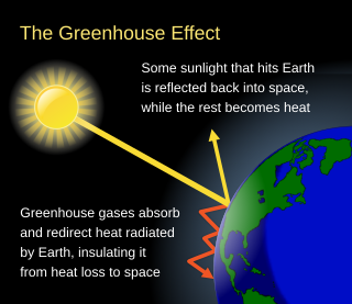
The greenhouse effect occurs when greenhouse gases in a planet's atmosphere cause some of the heat radiated from the planet's surface to build up at the planet's surface. This process happens because stars emit shortwave radiation that passes through greenhouse gases, but planets emit longwave radiation that is partly absorbed by greenhouse gases. That difference reduces the rate at which a planet can cool off in response to being warmed by its host star. Adding to greenhouse gases further reduces the rate a planet emits radiation to space, raising its average surface temperature.

Numerical climate models use quantitative methods to simulate the interactions of the important drivers of climate, including atmosphere, oceans, land surface and ice. They are used for a variety of purposes from study of the dynamics of the climate system to projections of future climate. Climate models may also be qualitative models and also narratives, largely descriptive, of possible futures.

Climatology or climate science is the scientific study of Earth's climate, typically defined as weather conditions averaged over a period of at least 30 years. Climate concerns the atmospheric condition during an extended to indefinite period of time; weather is the condition of the atmosphere during a relative brief period of time. The main topics of research are the study of climate variability, mechanisms of climate changes and modern climate change. This topic of study is regarded as part of the atmospheric sciences and a subdivision of physical geography, which is one of the Earth sciences. Climatology includes some aspects of oceanography and biogeochemistry.

A general circulation model (GCM) is a type of climate model. It employs a mathematical model of the general circulation of a planetary atmosphere or ocean. It uses the Navier–Stokes equations on a rotating sphere with thermodynamic terms for various energy sources. These equations are the basis for computer programs used to simulate the Earth's atmosphere or oceans. Atmospheric and oceanic GCMs are key components along with sea ice and land-surface components.
Atmospheric science is the study of the Earth's atmosphere and its various inner-working physical processes. Meteorology includes atmospheric chemistry and atmospheric physics with a major focus on weather forecasting. Climatology is the study of atmospheric changes that define average climates and their change over time, due to both natural and anthropogenic climate variability. Aeronomy is the study of the upper layers of the atmosphere, where dissociation and ionization are important. Atmospheric science has been extended to the field of planetary science and the study of the atmospheres of the planets and natural satellites of the Solar System.

A weather station is a facility, either on land or sea, with instruments and equipment for measuring atmospheric conditions to provide information for weather forecasts and to study the weather and climate. The measurements taken include temperature, atmospheric pressure, humidity, wind speed, wind direction, and precipitation amounts. Wind measurements are taken with as few other obstructions as possible, while temperature and humidity measurements are kept free from direct solar radiation, or insolation. Manual observations are taken at least once daily, while automated measurements are taken at least once an hour. Weather conditions out at sea are taken by ships and buoys, which measure slightly different meteorological quantities such as sea surface temperature (SST), wave height, and wave period. Drifting weather buoys outnumber their moored versions by a significant amount.
Numerical weather prediction (NWP) uses mathematical models of the atmosphere and oceans to predict the weather based on current weather conditions. Though first attempted in the 1920s, it was not until the advent of computer simulation in the 1950s that numerical weather predictions produced realistic results. A number of global and regional forecast models are run in different countries worldwide, using current weather observations relayed from radiosondes, weather satellites and other observing systems as inputs.

The ultraviolet index, or UV index, is an international standard measurement of the strength of the sunburn-producing ultraviolet (UV) radiation at a particular place and time. It is primarily used in daily and hourly forecasts aimed at the general public. The UV index is designed as an open-ended linear scale, directly proportional to the intensity of UV radiation, and adjusting for wavelength based on what causes human skin to sunburn. The purpose of the UV index is to help people effectively protect themselves from UV radiation, which has health benefits in moderation but in excess causes sunburn, skin aging, DNA damage, skin cancer, immunosuppression, and eye damage, such as cataracts.
Parameterization in a weather or climate model is a method of replacing processes that are too small-scale or complex to be physically represented in the model by a simplified process. This can be contrasted with other processes—e.g., large-scale flow of the atmosphere—that are explicitly resolved within the models. Associated with these parameterizations are various parameters used in the simplified processes. Examples include the descent rate of raindrops, convective clouds, simplifications of the atmospheric radiative transfer on the basis of atmospheric radiative transfer codes, and cloud microphysics. Radiative parameterizations are important to both atmospheric and oceanic modeling alike. Atmospheric emissions from different sources within individual grid boxes also need to be parameterized to determine their impact on air quality.
Data assimilation is a mathematical discipline that seeks to optimally combine theory with observations. There may be a number of different goals sought – for example, to determine the optimal state estimate of a system, to determine initial conditions for a numerical forecast model, to interpolate sparse observation data using knowledge of the system being observed, to set numerical parameters based on training a model from observed data. Depending on the goal, different solution methods may be used. Data assimilation is distinguished from other forms of machine learning, image analysis, and statistical methods in that it utilizes a dynamical model of the system being analyzed.

In atmospheric science, an atmospheric model is a mathematical model constructed around the full set of primitive, dynamical equations which govern atmospheric motions. It can supplement these equations with parameterizations for turbulent diffusion, radiation, moist processes, heat exchange, soil, vegetation, surface water, the kinematic effects of terrain, and convection. Most atmospheric models are numerical, i.e. they discretize equations of motion. They can predict microscale phenomena such as tornadoes and boundary layer eddies, sub-microscale turbulent flow over buildings, as well as synoptic and global flows. The horizontal domain of a model is either global, covering the entire Earth, or regional (limited-area), covering only part of the Earth. The different types of models run are thermotropic, barotropic, hydrostatic, and nonhydrostatic. Some of the model types make assumptions about the atmosphere which lengthens the time steps used and increases computational speed.
The Global Environmental Multiscale Model (GEM), often known as the CMC model in North America, is an integrated forecasting and data assimilation system developed in the Recherche en Prévision Numérique (RPN), Meteorological Research Branch (MRB), and the Canadian Meteorological Centre (CMC). Along with the NWS's Global Forecast System (GFS), which runs out to 16 days, the ECMWF's Integrated Forecast System (IFS), which runs out 10 days, the Naval Research Laboratory Navy Global Environmental Model (NAVGEM), which runs out eight days, the UK Met Office's Unified Model, which runs out to seven days, and Deutscher Wetterdienst's ICON, which runs out to 7.5 days, it is one of the global medium-range models in general use.

Dr. André Robert was a Canadian meteorologist who pioneered the modelling the Earth's atmospheric circulation.
JULES is a land-surface parameterisation model scheme describing soil-vegetation-atmosphere interactions. JULES is a community lead project which evolved from MOSES, the United Kingdom Meteorological Office Surface Exchange Scheme. It can be used as a stand-alone model or as the land surface part of the Met Office Unified Model. JULES has been used to help decide what tactics would be effective to help meet the goals of the Paris Agreement. As well as use by the Met Office climate modelling group a number of studies have cited JULES and used it as a tool to assess the effects of climate change, and to simulate environmental factors from groundwater to carbon in the atmosphere.

The temperatures of a planet's surface and atmosphere are governed by a delicate balancing of their energy flows. The idealized greenhouse model is based on the fact that certain gases in the Earth's atmosphere, including carbon dioxide and water vapour, are transparent to the high-frequency solar radiation, but are much more opaque to the lower frequency infrared radiation leaving Earth's surface. Thus heat is easily let in, but is partially trapped by these gases as it tries to leave. Rather than get hotter and hotter, Kirchhoff's law of thermal radiation says that the gases of the atmosphere also have to re-emit the infrared energy that they absorb, and they do so, also at long infrared wavelengths, both upwards into space as well as downwards back towards the Earth's surface. In the long-term, the planet's thermal inertia is surmounted and a new thermal equilibrium is reached when all energy arriving on the planet is leaving again at the same rate. In this steady-state model, the greenhouse gases cause the surface of the planet to be warmer than it would be without them, in order for a balanced amount of heat energy to finally be radiated out into space from the top of the atmosphere.
ECHAM is a general circulation model (GCM) developed by the Max Planck Institute for Meteorology, one of the research organisations of the Max Planck Society. It was created by modifying global forecast models developed by ECMWF to be used for climate research. The model was given its name as a combination of its origin and the place of development of its parameterisation package, Hamburg. The default configuration of the model resolves the atmosphere up to 10 hPa, but it can be reconfigured to 0.01 hPa for use in studying the stratosphere and lower mesosphere.
TOMCAT/SLIMCAT is an off-line chemical transport model (CTM), which models the time-dependent distribution of chemical species in the troposphere and stratosphere. It can be used to study topics such as ozone depletion and tropospheric pollution, and was one of the models used the IPCC report on Aviation and the Global Atmosphere. It incorporates a choice of detailed chemistry schemes for the troposphere or stratosphere, and an optional chemical data assimilation scheme.

The history of numerical weather prediction considers how current weather conditions as input into mathematical models of the atmosphere and oceans to predict the weather and future sea state has changed over the years. Though first attempted manually in the 1920s, it was not until the advent of the computer and computer simulation that computation time was reduced to less than the forecast period itself. ENIAC was used to create the first forecasts via computer in 1950, and over the years more powerful computers have been used to increase the size of initial datasets as well as include more complicated versions of the equations of motion. The development of global forecasting models led to the first climate models. The development of limited area (regional) models facilitated advances in forecasting the tracks of tropical cyclone as well as air quality in the 1970s and 1980s.
Earth systems models of intermediate complexity (EMICs) form an important class of climate models, primarily used to investigate the earth's systems on long timescales or at reduced computational cost. This is mostly achieved through operation at lower temporal and spatial resolution than more comprehensive general circulation models (GCMs). Due to the nonlinear relationship between spatial resolution and model run-speed, modest reductions in resolution can lead to large improvements in model run-speed. This has historically allowed the inclusion of previously unincorporated earth-systems such as ice sheets and carbon cycle feedbacks. These benefits are conventionally understood to come at the cost of some model accuracy. However, the degree to which higher resolution models improve accuracy rather than simply precision is contested.