
Suilven is a mountain in Scotland. Lying in a remote area in the west of Sutherland, it rises from a wilderness landscape of moorland, bogs and lochans known as Inverpolly National Nature Reserve. Suilven forms a steep-sided ridge some two kilometres in length. The highest point, Caisteal Liath, lies at the northwest end of this ridge. There are two other summits: Meall Meadhonach at the central point of the ridge is 723 metres (2,372 ft) high, whilst Meall Beag lies at the southeastern end.
Lochinver is a village at the head of the sea loch Loch Inver, on the coast in the Assynt district of Sutherland, Highland, Scotland. A few miles north-east is Loch Assynt which is the source of the River Inver which flows into Loch Inver at the village. There are 200 or so lochans in the area, popular with anglers. Lochinver is dominated by the "sugar loaf" shape of Caisteal Liath, the summit peak of nearby Suilven.

Assynt is a sparsely populated area in the south-west of Sutherland, lying north of Ullapool on the west coast of Scotland. Assynt is known for its landscape and its remarkable mountains, which have led to the area, along with neighbouring Coigach, being designated as the Assynt-Coigach National Scenic Area, one of 40 such areas in Scotland.

Canisp is a mountain in the far north west of Scotland. It is situated in the parish of Assynt, in the county of Sutherland, 25 kilometres (16 mi) north of the town of Ullapool. Canisp reaches a height of 847 metres (2,779 ft) and qualifies as a Corbett and Marilyn hill. The mountain's name translates from the Old Norse kambsnípa or point of the comb/ridge.

Loch Veyatie is a large freshwater loch in north-west Scotland. It stretches for 6 km north-westwards from the settlement of Elphin, and lies between Suilven and Cùl Mòr. The loch is located in an area known as the Assynt-Coigach National Scenic Area, one of 40 such areas in Scotland.
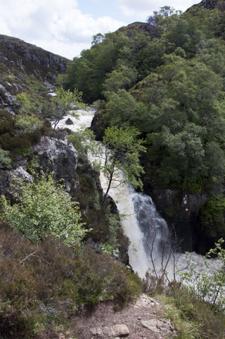
The Falls of Kirkaig are a waterfall in the Northwest Highlands of Scotland in the county of Sutherland. The fall is located on the River Kirkaig, south by southeast of the village of Lochinver, on the main approach footpath to Suilven mountain. About four miles across the hills to the west is Fionn Loch.

Loch Kirkaig is a small tidal sea loch, located in the region and parish of Assynt in south-west of Sutherland, in the west coast of Scotland and in the Scottish Highlands. Loch Kirkaig is 1.25 miles south of Loch Inver. The scattered crofting township of Inverkirkaig is located at the headland of the bay, next to the pebbly beach, on the round bay, which has no known name. The name Kirgaig comes from old Norse, Kirkju-vik meaning church bay, perhaps suggesting that in Viking times, there was a church, with a village located in the bay.

Loch Leitir Easaidh is a small shallow irregular shaped freshwater lochan that flows directly into the northwestern end of Loch Assynt in Assynt, Sutherland, Scotland. The loch is located in an area along with neighbouring Coigach, as the Assynt-Coigach National Scenic Area, one of 40 such areas in Scotland.

Loch Awe is a small loch, located 4 miles south of Loch Assynt and next to the village of Ledmore, within the Assynt area of Sutherland, Scotland. The loch is located in an area along with neighbouring Coigach, as the Assynt-Coigach National Scenic Area, one of 40 such areas in Scotland.

Loch Beannach is a small v-shaped loch, located 2 miles to the west of Loch Assynt and 3 miles northeast of Lochinver within the Assynt area of Sutherland, Scotland. The loch is located in an area known as the Assynt-Coigach National Scenic Area, one of 40 such areas in Scotland.

Loch Culag also known as Loch na Doire Daraich is a small freshwater shallow loch, located south of Lochinver in the Assynt district of Sutherland, Highland, Scotland. The loch is located in an area along with neighbouring Coigach, as the Assynt-Coigach National Scenic Area, one of 40 such areas in Scotland.

Loch Cròcach is a large irregular shaped, shallow loch, located about three miles north of Lochinver in the Assynt district of Sutherland, Highland, Scotland. It is one of five lochs in Scotland with the same name. Loch Cròcach is located in an area known as the Assynt-Coigach National Scenic Area, one of 40 such areas in Scotland.
Loch an Tuirc is a large irregular shaped, shallow loch, located about two miles north-by-north-east of Lochinver in the Assynt district of Sutherland, Highland, Scotland. It is one of three lochs in Scotland with the same name. Loch an Tuirc is located in an area known as the Assynt-Coigach National Scenic Area, one of 40 such areas in Scotland.

Cam Loch is an irregularly-shaped freshwater loch, about 5 km long, on a north-west to south-east orientation, located slightly north of the village of Elphin, in the Assynt district of Sutherland, Scotland. The loch is located in an area along with neighbouring Coigach, as the Assynt-Coigach National Scenic Area, one of 40 such areas in Scotland.

Loch a' Mhadail or Loch a' Mhiotailt is a small freshwater lochan that lies immediately to the south-west of Loch Veyatie and is connected by a channel to Loch Veyatie within the area of Inverpolly. The channel measures about 20 foot in length, 10 feet in width and 1 foot in depth. When the water level is low, Loch a' Mhadail is separated from Loch Veyatie by a dyke made of Gneiss.

Loch an Doire Dhuibh is a small irregular shaped freshwater loch, situated on a north-east to south-west orientation in northern Wester Ross and located 7.5 miles southeast of Lochinver, Scotland. Directly to the northwest of the loch is Loch Gainmheich, considered the "northern portion" of the loch, by the editors of Bathymetrical Survey that is connected by a narrow channel with water flowing out of Doire Dhuibh and northwest to Loch Sionascaig. Loch an Doire Dhuibh is part of the Assynt - Coigach National Scenic Area.

Loch Sionascaig is a large irregular shaped, freshwater loch in the remote Coigach area of northern Wester Ross. It is located 5.5 miles southeast of the village of Lochinver and is situated within the Inverpolly Forest.

Loch Lurgainn is a large remote and deep freshwater loch with a crescent shape with its concave side turned to the south. It is located in the Coigach peninsula in Lochbroom, Wester Ross. Loch Lurgainn is located 8 miles north of Ullapool and two miles south of Loch Sionascaig and is 3.5 miles southeast of Enard Bay. The scenic qualities of Coigach, along with neighbouring Assynt, have led to the area being designated as the Assynt-Coigach National Scenic Area, one of 40 such areas in Scotland. The main settlement in the area, located directly to the north-west is Achiltibuie.
Loch Bad a' Ghaill is a small remote and deep freshwater loch that is located 10 miles north of Ullapool and immediately north west of Loch Lurgainn. It is located in the Coigach peninsula in Lochbroom, Wester Ross. The scenic qualities of Coigach, along with neighbouring Assynt, have led to the area being designated as the Assynt-Coigach National Scenic Area, one of 40 such areas in Scotland. The main settlement in the area, located directly to the north-west is Achiltibuie.


