Fish Hoek Valley

Last updated

The Fish Hoek Valley is situated in the Cape Peninsula, eighteen miles south of Cape Town, South Africa. It takes its name from the town of Fish Hoek on the False Bay coast.

Contents

The valley is bound by mountains (including Chapman's Peak, Spitskop, Silvermine Mountain, and Ridge Peak) on the north; Fish Hoek Bay and False Bay on the east; mountains (including Elsie's Peak, Rooikrans, and Slangkop) on the south; and Chapman's Bay and the Atlantic Ocean on the west. It is 13 kilometres from west to east, and between 3 and 6 kilometres from north to south. The valley has several rivers and lakes.

The predominant vegetation type in this valley is endangered Hangklip Sand Fynbos. However, the sides of the valley are home to Cape Granite Fynbos, and Peninsula Sandstone Fynbos can be found higher up on the surrounding mountains. The latter two vegetation types (also both endangered) are endemic to the Cape Peninsula and can be found nowhere else in the world. [1]

Fish Hoek Valley was once rural, but today it is largely covered by suburbs and townships such as Kommetjie, Ocean View, Noordhoek, The Lakes, Masiphumelele, Capri Village, Sunnydale, Sun Valley, Fish Hoek, and Clovelly. Some rural aspects have been preserved in the form of heritage areas and parts of the Table Mountain National Park.

History

Pre-historic

Many millennia ago, the valley was a channel separating two islands off the African mainland. By 20 000 years ago, the sea had receded, the channel and the isthmus separating the islands from the mainland had become dry land, and the islands had become a peninsula. [2]

By 10 000 BCE, pre-Bushman people were living in caves in the slopes lining the valley. Several of their skeletons, weapons and other artefacts were unearthed in Peers Cave on the north-eastern side of the valley, in 1927. The skeletons were named 'Fish Hoek Man'.

By the first century AD 'Strandlopers' (Khoisan) were living on the slopes of Slangkop. A midden containing mussel, limpet and abalone shells, and various stone implements was uncovered there in 1972. [3]

17th century

The recorded history of the valley, and of South Africa as a whole, begins when the Dutch East India Company established a settlement at Table Bay, 28 kilometres north of the valley, in 1652. The Company regarded the whole of the Western Cape region as being under its jurisdiction, but in the early years its settlement remained confined to the northern peninsula. Its first venture into the southern peninsula is thought to have been in 1659, when troops combed the area in search of KhoiSan who had attacked the Company's settlement.

In the early 1680s, the Company explored the mountains on the northern side of the valley for silver deposits. The mountain, and a river which flows down it, became known as 'Zilvermyn'. In 1687, Governor Simon van der Stel explored the area, and reported an abundance of wild birds and wild game roaming the area. [4] Three years later, Van der Stel granted fishing and whaling rights at Visch Hoek on the eastern end of the valley a community of fishermen and whalers developed there, and a building was erected.

18th century

Permanent settlement of the valley began in 1743, when the Company established Simon's Bay, 3 kilometres south of Visch Hoek bay, as a winter anchorage. Governor-general Gustav van Imhoff granted three farms at the western end of the valley, probably to supply fresh produce to Simon's Bay. They were Slangkop ('Snake Peak'), De Goede Hoop ('Good Hope'), and Poespaskraal ('Hotch-potch kraal'). Half a century later, in 1797, when the colony was under British military occupation, a fourth farm was established, at Visch Hoek, but it was only on loan and the lease ended when the lessee died in 1808.

19th century

When the Cape became a permanent British colony in 1814, the Royal Navy established a permanent base at Simon's Town, and governor Sir John Cradock established the southern part of the Peninsula as the Simon's Town magisterial district. The road through Visch Hoek to Simon's Town was rebuilt in 1815.

Soon afterwards, two more farms were established, at the eastern end of the valley. In 1815, Governor Lord Charles Somerset granted a 112-hectare farm on the slopes of the Zilvermyn mountain - appropriately, the farm was named Zilvermyn. In 1818, Somerset granted the 1528-hectare Visch Hoek property as a farm, on condition that the owner was not allowed to sell liquor. When Visch Hoek was subdivided in 1827, the 454-hectare portion north of the Zilvermyn river became a separate farm named Klein Tuin ('small garden').

Later, a farm named Brakkloof (or Brakke Kloof) was granted between Visch Hoek and Poespaskraal.

Farm names were changed from time to time. Slangkop also became known as 'Imhoff's Gift', De Goede Hoop as 'Noordhoek', and Poespaskraal as 'Sunnydale'.

In 1855, a divisional council (comparable to a county council in England) was established to administer the Cape Division, i.e. the rural areas surrounding Cape Town. It administered the valley for the following 131 years, except during the years 1879 to 1888, when the Simon's Town magisterial district was a division with its own divisional council.

Another farm was created in the late 1850s, when Slangkop / Imhoff's Gift was subdivided and the south-eastern portion became Ocean View. [3]

By the end of the 19th century, the south peninsula was well established. The railway line was extended from the seaside town of Kalk Bay through Visch Hoek to Simon's Town in 1890. When Kalk Bay was proclaimed a municipality in 1895, the farm Klein Tuin was included within its boundaries.

20th century

Like the rest of the colony, the Simon's Town district was under martial law during 1901 and 1902, because of the Anglo-Boer War, the invasion of the British of the Boer countries to the North. The Transvaal and Free State.

The first townships were established in the valley towards the end of the war. Kommetje Estates Ltd bought Slangkop farm in 1900 and established a seaside village named Kommetje. At the other end of the valley, G.W. MacIntyre bought Klein Tuin in 1902, renamed it 'Mayville', and established a small seaside suburb (which was later renamed 'Clovelly').

Parliament approved the construction of a branch railway line from Visch Hoek to Kommetje, [5] but it was never built. Eventually, ten years later, in 1913, the divisional council built Kommetje Road (now route M65), leading from Visch Hoek across the southern side of the valley, to Kommetje.

The Kalk Bay municipality, including Mayville (Clovelly), was incorporated into the City of Cape Town in 1913, but the rest of the valley remained under the divisional council.

During World War I, the Simon's Town district was under martial law to protect the naval base, and travel through the valley was hampered by military roadblocks. The German navy cruiser Möwe was seen in Chapman's Bay, off Slangkop, in 1916. [3]

Two more townships were developed after the war. Visch Hoek (or 'Fish Hoek') farm was subdivided into a township in 1918, and grew rapidly. A local board was established in 1921, and a village management board in 1927. The prohibition against the sale of liquor imposed a century earlier still held good, and the town became well known for being the only 'dry' town in the country.

Part of Noordhoek was subdivided for residential development in 1920. [6] Access to the western end of the valley was improved when the divisional council opened Chapman's Peak Drive (now part of route M6) in 1922, as part of a scenic motor route around the Peninsula. [6]

Cape Estates Ltd bought the undeveloped part of Mayville in 1922, and established the Clovelly Country Club.

Fish Hoek was proclaimed a municipality in 1940.

German submarines were active in Cape waters during World War II. A military radar station was established on Slangkop, to monitor the ocean, and a small military camp named 'Cobra' was opened to house the personnel. Two German anti-ship mines washed up at Kommetjie the navy dismantled one and detonated the other. [3]

After the war, most of Sunnydale farm was subdivided into a residential township.

The divisional council undertook considerable development in the valley during the 1960s and 1970s. In the 1960s, it developed a White residential township, named Sun Valley, on Brakkloof farm., [6] and a Coloured township on Ocean View farm, to accommodate the communities which the government had forced to move out of Fish Hoek, Sunnydale, and Simon's Town under its apartheid system. In 1968, the council opened the 'Ou Kaapse Weg' ('Old Cape Road') (now route M64), leading from Sunnydale over the Silvermine mountain to Tokai. [6]

In the 1970s, the council opened Soetwater caravan park (for Coloured holidaymakers), and Imhoff caravan park (for Whites) near Kommetjie. [6] Wildevoëlvlei sewage works were opened in 1977 [6]

Part of Sunnydale was developed into a residential township named Capri Village .

The divisional council was absorbed into the Western Cape Regional Services Council in 1986.

In 1986, the Black residents of Dassenberg were forcibly evicted under the apartheid laws and re-settled at Khayalitsha. They were allowed to return to the valley in 1989, and a new settlement was established for them on part of Sunnydale it was later named Masiphumelele ('we will succeed'). [7] Apartheid ended in 1994.

In 1996, the valley was incorporated into the new South Peninsula Municipality, and Fish Hoek's municipality was dissolved. Four years later, the South Peninsula Municipality was incorporated into the City of Cape Town, which now administers the valley.

Some notable events

1725 : A pirate ship anchored in Visch Hoek bay Dutch East India Company troops were sent to the valley to prevent the pirates scouring the countryside for food and drink.

1795 : British military forces invaded the colony. They marched from Simon's Town along the road past Visch Hoek beach, and overran a Dutch East India Company artillery emplacement at the northern corner of the valley the abandoned guns are now displayed at the Clovelly Country Club.

1821 : The brig Waterloo was wrecked off Visch Hoek beach.

1860] : The valley welcomed its (and the colony's) first royal visitor, when Prince Alfred travelled through the valley en route from Simon's Town to Cape Town.

1885 : A huge octopus with a 3-metre-long body and 8-metre-long tentacles, washed up on Noordhoek beach. [8]

1900 : The steamship SS Kakapo was wrecked off Noordhoek beach. Some of the metal plates were later used as a barricade to protect the railway line, others were removed during World War II to be recycled into armaments.

1908 : The valley's first school was opened, at Kommetjie.

1910 : A wireless station was established on the seaward slopes of Slangkop it was later moved to Kommetje, because of interference from manganese deposits in the mountain.

1914 : A lighthouse was built on the mountain, but because of the outbreak of World War I, it was not put into commission until 1919.

1927 : Victor and Bertie Peers unearthed the remains of 'Fish Hoek Man' in a cave above Fish Hoek. [9] The cave was proclaimed a national monument in 1941.

1928 : More than 100 False Killer whales beached themselves at Kommetjie few could be saved.

1930 : Motor racing began on the Noordhoek salt pan it continued until 1939.

1934 : A whale shark washed up on Kommetjie beach. [8]

1936 : A devastating mountain fire on the Brakkloof mountain threatened Fish Hoek.

1963 : The provincial administration opened the valley's first hospital - the False Bay Hospital in Fish Hoek.

1969 : Part of the film Ryan's Daughter was filmed around the remains of the Kakapo on Noordhoek beach.

1970 : The first annual Two Oceans Marathon was run the route passes through the valley.

1972 : A 2000-year-old midden containing mussel, limpet and abalone shells, and various stone implements was uncovered at Kommetjie in 1972. [3]

2000 : Devastating mountain fires ravaged the southern Peninsula for several days in parts of Noordhoek and Kommetjie were evacuated until the fire services and air force had extinguished the blazes.

2008 : Xenophobic riots displaced many Ocean View and Masiphumelele residents they had to be housed in camps at Soetwater.

2009 : 55 False Killer whales beached themselves at Kommetjie only a few could be saved and returned to the sea.

2010: A rhinodon typicus shark - one of the rarest in the world - washed up on Cape Point Reserve.

2013 : 19 pilot whales beached themselves at Noordhoek only one could be saved and returned to the sea.

Related Research Articles

Cape Town Legislative capital of South Africa

Cape Town is the second-most populous city in South Africa, after Johannesburg, and also the legislative capital of South Africa.

Table Mountain A flat-topped mountain overlooking the city of Cape Town

Table Mountain is a flat-topped mountain forming a prominent landmark overlooking the city of Cape Town in South Africa. It is a significant tourist attraction, with many visitors using the cableway or hiking to the top. The mountain forms part of the Table Mountain National Park, and part of the lands formerly ranged by Khoe-speaking clans, such as the !Uriǁʼaes. It is home to a large array of mostly endemic fauna and flora.

Masiphumelele Suburb of Cape Town, Western Cape, South Africa

Masiphumelele is a township on the Cape Peninsula, South Africa, situated between Kommetjie, Capri Village and Noordhoek.

Kommetjie Seaside suburb of Cape Town, Western Cape, South Africa

Kommetjie is a small town near Cape Town, in the Western Cape province of South Africa. It lies about halfway down the west coast of the Cape Peninsula, at the southern end of the long wide beach that runs northwards towards Chapman's Peak and Noordhoek.

Fish Hoek Place in Western Cape, South Africa

Fish Hoek is a coastal suburb at the eastern end of the Fish Hoek Valley on the False Bay side of the Cape Peninsula in the Western Cape, South Africa. Previously a separate municipality, Fish Hoek is now part of the City of Cape Town. As a coastal suburb of Cape Town, Fish Hoek is popular as a residence for commuters, retired people and holidaymakers alike. The traditional industries of 'trek' fishing and angling coexist with the leisure pursuits of surfing, sailing and sunbathing. There is an active lifeguard community who utilise the beach and bay for training.

False Bay Large bay of the Atlantic Ocean at Cape Town, South Africa

False Bay is a body of water in the Atlantic Ocean between the mountainous Cape Peninsula and the Hottentots Holland Mountains in the extreme south-west of South Africa. The mouth of the bay faces south and is demarcated by Cape Point to the west and Cape Hangklip to the east. The north side of the bay is the low-lying Cape Flats, and the east side is the foot of the Hottentots Holland Mountains to Cape Hangklip which is at nearly the same latitude as Cape Point. In plan the bay is approximately square, being roughly the same extent from north to south as east to west, with the southern side open to the ocean. The seabed slopes gradually down from north to south, and is mostly fairly flat unconsolidated sediments. Much of the bay is off the coast of the City of Cape Town, and it includes part of the Table Mountain National Park Marine Protected Area and the whole of the Helderberg Marine Protected Area. The name "False Bay" was applied at least three hundred years ago by sailors returning from the east who confused Cape Point and Cape Hangklip, which are somewhat similar in form.

Hout Bay seaside suburb of Cape Town, Western Cape, South Africa

Hout Bay is a seaside suburb of Cape Town in the Western Cape province of South Africa. It is situated in a valley on the Atlantic seaboard of the Cape Peninsula, twenty kilometres south of the Central Business District. The name "Hout Bay" can refer to the suburb, the bay on which it is situated, or the entire valley.

Noordhoek, Cape Town Place in Western Cape, South Africa

Noordhoek is a seaside town in the Western Cape, South Africa, located below Chapman's Peak on the west coast of the Cape Peninsula and is approximately 35 kilometres (22 mi) to the south of Cape Town. The name "Noordhoek" was taken from Dutch and literally means "north corner". It is best known for its shoreline and its long, wide, sandy beach, which stretches south to the neighbouring village of Kommetjie. Near the southern end of this beach is the wreck of the steamship "Kakapo", which ran aground in 1900, when the captain mistook Chapmans' Peak for the Cape of Good Hope and put the helm over to port.

Table Mountain National Park A national park on the Cape Peninsula in the vicinity of Cape Town, South Africa

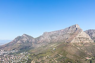
Table Mountain National Park, previously known as the Cape Peninsula National Park, is a national park in Cape Town, South Africa, proclaimed on 29 May 1998, for the purpose of protecting the natural environment of the Table Mountain Chain, and in particular the rare fynbos vegetation. The park is managed by South African National Parks. The property is included as part of the UNESCO Cape Floral Region World Heritage Site.

short description|List of beaches in the Cape Town metropolitan region Image:Muizenberg ZA bathing huts.jpg|thumb|right|250px|[Muizenbergbeach The Cape Metropole has a wide variety of beaches divided into three regions by the Cape Peninsula:

M3 (Cape Town) Expressway in Cape Town, South Africa, between the City Bowl to the Southern Suburbs

The M3 is an expressway in Cape Town, South Africa, connecting the upper part of the City Bowl to the Southern Suburbs and ending in Tokai. For most of its route it parallels - though further to the south and west - the M4, which was the original road connecting central Cape Town with the settlements to the south.

Capri Village Suburb of Cape Town , South Africa

Capri Village is a small suburb of Cape Town on the Cape Peninsula, South Africa, situated between Kommetjie, Fish Hoek and Noordhoek.

Simons Town railway station Metrorail railway station at the end of the Southern Line

Simon's Town railway station is a Metrorail railway station in the town of Simon's Town on the Cape Peninsula; it is the southern terminus of the Southern Line. The station is located between Station Road and the beach.

Geology of Cape Town Geological formations and their history in the vicinity of Cape Town

Cape Town lies at the south-western corner of the continent of Africa. It is bounded to the south and west by the Atlantic Ocean, and to the north and east by various other municipalities in the Western Cape province of South Africa.

Glencairn, Cape Town Seaside suburb of Cape Town in Western Cape, South Africa

Glencairn is a suburb of Cape Town, South Africa. It is situated about 4 km north of Simonstown, on the shore of False Bay. Access can be made from Fish Hoek or Simonstown via the M4, or from Noordhoek via the M6. Glencairn is made up of Glencairn Heights, Glen Ridge and Welcome Glen. There is a train stop at the south end of the suburb, with views across False Bay. The beach is actively utilised for leisure activities such as swimming, surfing, kayaking and snorkeling. The Glencairn tidal pool can be enjoyed on a high tide at the south end of the beach. The Glencairn Wetland conserves the lower Else River.

Ou Kaapse Weg Mountain pass in the Cape Peninsula between the Southern Suburbs and Fish Hoek Valley

Ou Kaapse Weg, numbered as route M64, is a mountain pass in the Cape Peninsula that connects the Southern Suburbs of Cape Town with the Fish Hoek Valley. It traverses the Steenberg mountains and passes through the Silvermine Nature Reserve. Ou Kaapse Weg is one of three routes to the Fish Hoek Valley: the others are Chapman's Peak Drive along the Atlantic coast and Main Road along the False Bay coast. Despite its name, the pass was only constructed in 1968, by the Divisional Council of the Cape.

Fish Hoek Library Public library in Fish Hoek in Cape Town, South Africa

Fish Hoek Library is a public library in the seaside suburb of Fish Hoek in Cape Town, South Africa. It was ranked 5th in the City of Cape Town's top circulating libraries in 2015

Outline of Cape Town List of links to articles about Cape Town on Wikipedia

The following outline is provided as an overview of and topical guide to Cape Town:

Seaside resorts in South Africa

This is a list of seaside resorts in South Africa. These seaside resorts are in the Eastern Cape, KwaZulu-Natal, Northern Cape and Western Cape provinces which are all coastal provinces of South Africa.

References

  1. "Archived copy". Archived from the original on 2012-12-23. Retrieved 2013-05-06.CS1 maint: discouraged parameter (link) CS1 maint: archived copy as title (link)
  2. MacPhee, D. & De Wit, M. (2003) How the Cape Got its Shape.
  3. 1 2 3 4 5 Midgley, J.F. (1984). Kommetjie CP - Its Story.
  4. Burman, J. (1977). The False Bay Story.
  5. Act 14 of 1903 (Cape Colony)
  6. 1 2 3 4 5 6 Annual Report of the Divisional Council of the Cape
  7. Cole, J. 'Revolt a symptom of historical pain' in Cape Argus (8 August 2008)
  8. 1 2 Green, L.G. (1947). Tavern of the Seas.
  9. Greenland, C. (1978) The Story of Peers Cave

http://www.fishhoekvalley.com

Coordinates: 34°7′30″S18°23′45″E / 34.12500°S 18.39583°E / -34.12500; 18.39583